
Ulldecona rock art (Abrics de l’Ermita) and the Serra del Montsià
Historic siteThe Ulldecona rock art, the Abrics de l’Ermita, is a group of prehistoric painted rock shelters in the Serra de Godall beside the Ermita de la Pietat hermitage, about 4 km north of Ulldecona in southern Catalonia, on the road towards Tortosa. Since 1998 it has been part of UNESCO’s World Heritage Site for the rock art of the Mediterranean Basin, and you see it only on a guided tour that starts at the interpretation centre below the hermitage. Across the valley rises the Serra del Montsià, the limestone range above La Ràpita and Alcanar, with walking routes up to the Roca Foradada. It suits people interested in prehistory and walkers; skip the rock art if you expect big cave galleries: the figures are small, and the standard tour shows two shelters.
Quick facts
- Names: Abrics de l’Ermita (Catalan, “the hermitage shelters”), also Pintures rupestres d’Ulldecona; in Spanish Abrigos de la Ermita. The hermitage is the Ermita de la Pietat.
- Where: Serra de Godall (also Serra de l’Ermita), municipality of Ulldecona, Montsià district, Tarragona province. Address on catalunya.com: Ulldecona–Tortosa road, Ermita de la Pietat, 43550 Ulldecona.
- Coordinates: 40.6332, 0.4698 (interpretation centre, OpenStreetMap).
- The site: up to fourteen decorated shelters along almost 500 m, with up to 386 figures (catalunya.com); the Catalan Wikipedia counts 13 shelters.
- Found: 31 March 1975, by the Ulldecona caving group, in shelter V.
- World Heritage: 1998, with the other rock art sites of the Mediterranean arc of the Iberian Peninsula.
- From La Ràpita: about 10 km in a straight line.
Getting there and parking
By car: the hermitage lies on the Serra de Godall about 4 km north of Ulldecona. The Catalan Wikipedia describes two ways up: the old path round the side of the range, or the road that leaves the Ulldecona–Tortosa road, where a small chapel marks the turn. A wide open area outside the hermitage walls is used as a car park.
From the coast: the site is about 10 km from La Ràpita and 10 km from Alcanar in a straight line; Ulldecona town lies about 4.5 km to the south.
Public transport: we could not confirm a bus to the hermitage; plan on a car or taxi.
Tours, hours and booking
The guided tour has two parts (catalunya.com). First you visit the Centre d’Interpretació d’Art Rupestre Abrics de l’Ermita, run by Ulldecona town council, in the lower floor of the hermitage. Then the guide takes you to shelters I and IV. Tour times, checked November 2026 on catalunya.com:
- Summer: Tuesday to Saturday at 10:00, 12:00 and 17:00; Sundays and public holidays at 10:00 and 12:00.
- Winter: Tuesday to Saturday at 10:00, 12:00 and 16:00; Sundays and public holidays at 10:00 and 12:00.
- Closed: Mondays.
- Languages: Catalan and Spanish.
We could not confirm current prices or whether booking is required; ask the Ulldecona tourist office. It sits in a modernist former mill built in 1923 by César Martinell, at Passeig de l’Estació, 6, and sells a package covering the rock art, the medieval castle and the town’s ancient olive trees. Its hours on catalunya.com: in summer Tuesday to Saturday 9:30–14:00 and 16:30–18:30, Sundays and holidays 10:00–13:30; in winter Tuesday to Friday 9:30–14:00, Saturday 9:30–14:00 and 16:00–18:00, Sundays and holidays 10:00–13:30.
What you see
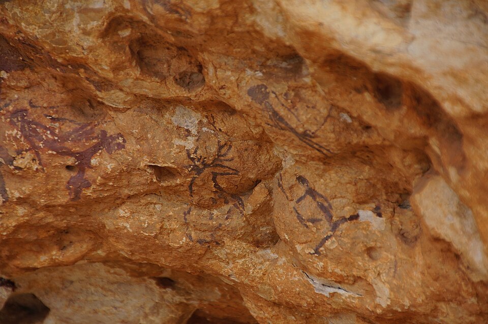
The paintings are in the Levantine style and, according to the Catalan Wikipedia, range from naturalistic to schematic, dated from a pre-pottery period (6000–5000 BC) to the Bronze Age. The colours are mainly red and black. The site is described as the largest and best-preserved group of Levantine rock art in Catalonia.
- Shelter I: the richest, with about 170 figures: a hunting scene in which archers surround deer and goats. Figures known as El Bruixot (the sorcerer), the outlined stag and La Dona (the woman) stand out. Since 2009 the shelter has been viewed from a platform for groups of 12.
- Shelter IV (Cova Fosca): a large shelter in the middle of the group, with semi-schematic and abstract figures.
- Shelter VIII (optional): the closest to the hermitage, opened to visits in 2016, with six naturalistic figures including a hunter and a young goat.
The interpretation centre, opened in 2006, explains the paintings with photos, tracings and a short animated film. It is part of the Rock Art Route of the Museu d’Arqueologia de Catalunya. The shelters themselves are privately owned.
The Ermita de la Pietat itself is a hermitage with a guesthouse, first documented in 1445, built against the rock of the Serra de Godall. It was burnt in 1936 and rebuilt from 1939 (Catalan Wikipedia).
The Serra del Montsià
Across the Ulldecona–Freginals valley to the east, the Serra del Montsià runs parallel to the coast between the Ebro and the Sénia rivers, about 12 km long and 5 km wide (Catalan Wikipedia). It is a limestone range with cliffs, gullies and caves, split between Alcanar, Ulldecona, Freginals, Amposta and La Ràpita, and protected under Catalonia’s PEIN plan since 2000.
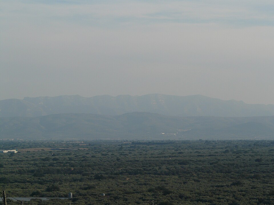
- Highest point: the Torreta del Montsià, 764 m (Catalan Wikipedia).
- Roca Foradada: a rock window at about 650 m that looks out over La Ràpita and the Alfacs bay (catalunya.com). It lies about 4 km from La Ràpita in a straight line.
- Access from La Ràpita: catalunya.com gives the Camí de Mata-redona, which starts beside the football ground in La Ràpita. The protected area is open all year.
- Activities: hiking, mountain biking and climbing; the Catalan Wikipedia says these, with hunting, are the only activities allowed in the protected area.
- Wildlife: Bonelli’s and golden eagles breed here, along with spectacled warblers and black wheatears (catalunya.com); Mediterranean tortoises have been reintroduced (Catalan Wikipedia).
We could not confirm current marked route numbers, distances or times from an official source; use an up-to-date hiking map.
Accessibility and safety
The shelters are on the hillside and reached on foot; we could not confirm step-free access to them, so ask the tourist office before you book if you use a wheelchair. The interpretation centre is in the hermitage building. On the Montsià, the terrain is steep and rocky with cliffs and little shade, and we found no official information on water points. Carry water, avoid the hottest hours in summer, and check fire-risk restrictions before you set out.
Best time to visit
Tours run all year except Mondays. For walking on the Montsià, spring, autumn and mild winter days are better than midsummer. In summer, the morning tours are cooler than the afternoon slot.
Nearby alternatives
- La Ràpita, about 10 km: the seaside town below the Montsià, a good base for both the hills and the delta.
- Alcanar and Les Cases d’Alcanar, about 10 km: the southernmost town in Catalonia, with a fishing village and quiet coast.
- Ermita de la Misericòrdia, about 14 km: another hilltop hermitage, above Vinaròs.
- Els Ports Natural Park: the higher limestone mountains inland, for longer walks.
- Ebro Delta, about 24 km: rice fields, lagoons and birds.
- Sant Jaume d’Enveja, about 23 km: the delta village on the south bank of the Ebro.
Distances are in a straight line from the interpretation centre. For the whole coast, see our Ebro Delta and southern Costa Dorada guide.
FAQ
Where are the Ulldecona cave paintings?
At the Abrics de l’Ermita in the Serra de Godall, next to the Ermita de la Pietat about 4 km north of Ulldecona, off the road to Tortosa. Coordinates of the interpretation centre: 40.6332, 0.4698.
Can you visit the Ulldecona rock art without a guide?
No. Visits are guided and start at the interpretation centre, then go to shelters I and IV. There are tours from Tuesday to Sunday; the site is closed on Mondays.
Why is the Ulldecona rock art a World Heritage Site?
Since 1998 it has been part of the UNESCO listing of rock art of the Mediterranean Basin on the Iberian Peninsula. It is the largest and best-preserved group of Levantine-style rock art in Catalonia.
What is the highest point of the Serra del Montsià?
The Torreta del Montsià, 764 m. The Roca Foradada, a rock window at about 650 m, is the best-known viewpoint, over La Ràpita and the Alfacs bay.
Sources and freshness
Checked 10 November 2026 · 4 sources Show
Checked 10 November 2026. Official:
- Catalan tourism portal on the Abrics de l’Ermita (discovery, size, tour, hours, address
- also in Catalan), the Ulldecona tourist office (address, package, hours) and the Serra del Montsià protected area (Foradada, access, wildlife
- also in Catalan). Background: Catalan Wikipedia on Ulldecona (rock art, shelters, dating, World Heritage), the Ermita de la Pietat (access, parking, history) and the Serra del Montsià (size, summit, protection)
- English Wikipedia on Ulldecona. The town hall’s website and the UNESCO site could not be reached when we checked. Location and distances: OpenStreetMap contributors (ODbL). Photos: Wikimedia Commons, licences as credited
This place is part of our Costa Dorada map and travel guide: Roman Tarragona, Salou and the Ebro Delta — see every town, beach and cove we have mapped on that coast.
How this page is made. CostaMap is written with an AI editorial system run by Ebizapple. This page is based on the sources listed above. Last updated 10 November 2026. Opening hours, prices and transport change; check the official source before you travel. How we work · Partner links and ads