
Serra de Tramuntana (Mallorca)
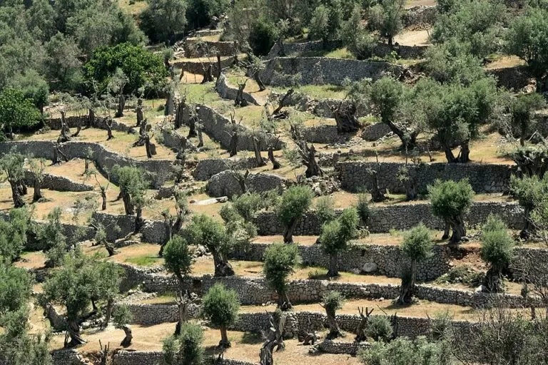
Natural parkThe Serra de Tramuntana is the mountain range along Mallorca’s north-west coast, listed by UNESCO in June 2011 as a cultural landscape of farming terraces, dry-stone walls and water channels. The easiest way in is the Sóller valley: the wooden train from Palma climbs through the range to Sóller, and the village of Fornalutx, where this guide’s map pin sits, is about 3 km from Sóller station. The GR 221 Dry Stone Route crosses the whole range on foot. It suits walkers, cyclists and anyone who likes mountain villages; skip it if you want beach time and flat roads.
Quick facts
- Names: Serra de Tramuntana in Catalan, Sierra de Tramontana in Spanish; in English often the Tramuntana mountains.
- Where: the north-west of Mallorca (Balearic Islands), forming the island’s northern backbone from south-west to north-east. It is also the name of the comarca.
- Coordinates: 39.7826, 2.7411 (Fornalutx, above the Sóller valley).
- World Heritage: listed on 27 June 2011 as the Cultural Landscape of the Serra de Tramuntana.
- Highest point: Puig Major, 1,445 m, the highest mountain in the Balearic Islands; its summit is a military zone.
- Long-distance path: GR 221, the Ruta de Pedra en Sec (Dry Stone Route), from Port d’Andratx to Port de Pollença.
- Entry: free; the range is open countryside with villages, private estates and public paths.
Access and parking
By train: the Ferrocarril de Sóller runs from Palma to Sóller on 914 mm narrow-gauge track through 13 tunnels in the range. It was built from 1911 on the profits of the orange and lemon trade, and from Sóller station a tram continues to Port de Sóller (Wikipedia). The Balearic tourist board calls the old wooden train the most authentic way to reach Sóller (illesbalears.travel). Sóller station is about 3 km from Fornalutx.
By bus: OpenStreetMap marks a Consorci de Transports de Mallorca bus stop in Fornalutx, about 230 m from the centre. We could not confirm timetables.
By car: mountain roads are narrow and winding. The Ma-2141 down to Sa Calobra, over the Coll de Cal Reis, is one of the best-known roads in Spain and a target for road cyclists. In Fornalutx, large vehicles are discouraged from the centre by a weight limit and a narrow bottleneck (Wikipedia). OpenStreetMap shows several paid surface car parks within 100–250 m of the village centre.
What to expect
UNESCO listed the range for what people built on it. Its statement describes a sheer-sided range parallel to the north-west coast, transformed by centuries of farming with scarce resources: agricultural terraces, interconnected water works including water mills, dry-stone constructions and farms of feudal origin (quoted on Wikipedia).
Sóller and Fornalutx: Sóller lies in the “golden valley”, among orange and lemon groves that thrive in the valley’s microclimate. Its prosperity came from exporting citrus and wine to France through its port, which shows in its French-influenced manor houses and modernist buildings (illesbalears.travel). Fornalutx, uphill, is a stone village of about 700 people with red roof tiles, green shutters, stepped and cobbled lanes and orchards, and has won awards for conservation since the 1980s. Water still runs in open stone channels beside its roads.
Walking: the GR 221 was the first long-distance path planned in the Balearics, presented by the Consell de Mallorca in 1996. Its main route links Port d’Andratx with Port de Pollença through Estellencs, Banyalbufar, Valldemossa, Deià, Sóller, Biniaraix and Lluc, with mountain refuges at stage ends; 261.1 km are open and waymarked, counting the variants (Viquipèdia). Near Fornalutx, the stone path up the Barranc de Biniaraix, about 1.4 km away, is one of the route’s highlights. The Balearic board also lists the GR 222 from Artà to Lluc.
Nature: the range is wetter and cooler than the rest of Mallorca, with snow on a few winter days. It holds 25 endemic plant species, and birds such as the black vulture, osprey, booted eagle and Eleonora’s falcon (Wikipedia).
Practical details
- Puig Major: the summit has been a military site since a US air base was built there in 1957–59; walkers use routes around it, such as the Penyal des Migdia (Wikipedia).
- Train tickets: buy from the Ferrocarril de Sóller; we could not confirm 2026 prices from the operator’s site, which we could not reach.
- Refuges: the GR 221 stages end at refuges such as Muleta, near Port de Sóller, and Tossals Verds; book ahead.
- Port de Sóller: the tram ends by the port and its beach; you can walk on to the Cap Gros lighthouse.
Accessibility and safety
Mountain paths are stony and steep, and stages of the GR 221 such as Muleta to Tossals Verds are long with big climbs. Carry water, check the weather, and do not rely on phone signal. In summer heat start early. Roads are narrow with hairpins and many cyclists. The villages have steep stepped lanes; we could not confirm step-free routes. The train is the most practical way in for visitors with limited mobility, but we could not confirm wheelchair access on board.
Best time to visit
Spring and autumn are the best seasons for walking: cooler than summer, and the Balearic board calls a spring walk through the orange groves round Sóller a spectacle for all five senses. Summer is hot on the paths and busy in the villages and car parks. Winter can bring rain and occasional snow on the high ground, but quiet trails on clear days.
Nearby alternatives
- Port de Sóller, 4.3 km: the harbour at the end of the tram line.
- Mirador de Sa Foradada, 10.1 km: the viewpoint at Son Marroig, near Deià.
- Torrent de Pareis, 10.3 km: the gorge walk down to Sa Calobra.
- Mirador de Ses Ànimes, 23.4 km: the watchtower above Banyalbufar’s terraces.
- Sa Dragonera, 42 km: the island at the range’s south-western tip.
Distances are in a straight line from Fornalutx.
FAQ
Why is the Serra de Tramuntana a World Heritage Site?
UNESCO listed it in 2011 as a cultural landscape: centuries of farming built terraces, dry-stone walls, water channels, mills and farms across a steep range.
Can you walk across the Serra de Tramuntana?
Yes. The GR 221 Dry Stone Route links Port d’Andratx and Port de Pollença, with refuges along the way; 261.1 km are waymarked including variants.
Can you climb Puig Major?
Not to the summit, which is a military zone. Walkers use nearby routes such as the Penyal des Migdia.
How do I get to Sóller from Palma without a car?
Take the Ferrocarril de Sóller, the narrow-gauge train through 13 tunnels, then the tram if you want to continue to Port de Sóller.
Is there parking in Fornalutx?
Yes. OpenStreetMap shows several paid car parks within about 250 m of the centre. Large vehicles should avoid the narrow centre.
Sources and freshness
Checked 6 November 2026 · 3 sources Show
Checked 6 November 2026. Official:
- Balearic Islands tourist board on hiking (GR 221, GR 222, UNESCO), Sóller (valley, train, tram, port) and natural heritage
- spain.info, Sóller. The Consell de Mallorca, Serra de Tramuntana and Ferrocarril de Sóller websites could not be reached. Background: Wikipedia on the Serra de Tramuntana, Puig Major, the Sóller railway and Fornalutx
- Viquipèdia, Ruta de la Pedra en Sec. Location, bus stop, car parks and distances: OpenStreetMap
This place is part of our Balearic Islands travel guide: Mallorca, Menorca, Ibiza and Formentera — see every town, beach and cove we have mapped on that coast.
How this page is made. CostaMap is written with an AI editorial system run by Ebizapple. This page is based on the sources listed above. Last updated 6 November 2026. Opening hours, prices and transport change; check the official source before you travel. How we work · Partner links and ads