
Sa Dragonera (Sant Elm, Andratx)
IslandSa Dragonera is an uninhabited island off the south-west tip of Mallorca, about 2 km by boat from the small pier at Sant Elm (Andratx). Small passenger boats cross from Sant Elm, normally between March and October, and you land at Cala Lledó, where the natural park’s information centre stands; from there four marked paths lead to a viewpoint and three lighthouses. Entry to the park is free, but tourist-boat passengers pay a €1 park fee. It suits walkers, birdwatchers and families who can manage rough paths in the sun; skip it if you need step-free access or want a beach day with a bar.
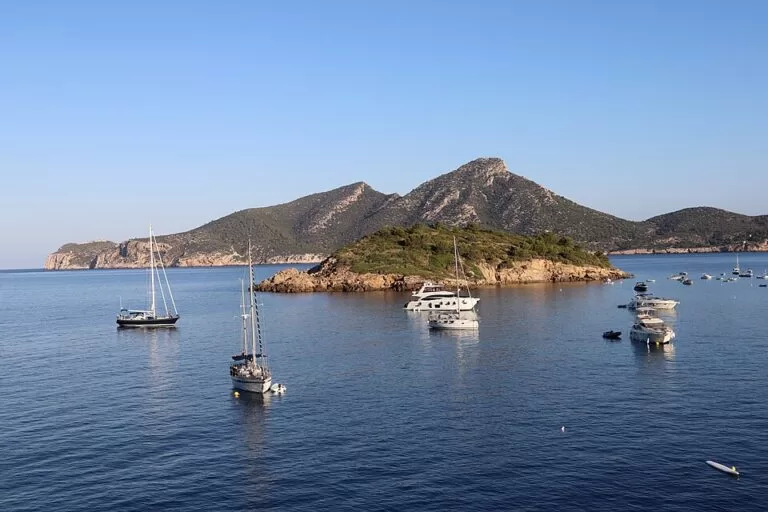
Quick facts
- Names: Sa Dragonera in Catalan, Dragonera in Spanish. The park also covers the islets of Es Pantaleu and Sa Mitjana.
- Where: off Sant Elm (Andratx), across a channel about 800 m wide and up to 15 m deep.
- Coordinates: 39.5852, 2.3197 (island). Landing pier at Cala Lledó: 39.5877, 2.3287.
- Size: 275 ha of land.
- Protection: natural park since 1995 and a Natura 2000 site.
- Entry: free; groups of more than 10 people need prior authorisation from the park.
- Park fee: €1 per person if you come on a tourist boat, collected by the boat company (checked November 2026).
- Facilities: information centre with an exhibition, public toilets. No bar, no shop, no drinking water.
Access and parking
By car to Sant Elm: from Palma take the Ma-1 motorway towards Andratx. From Port d’Andratx take the Ma-1050 towards s’Arracó and then the Ma-1030, which ends in Sant Elm. Signs at the entrance to the village point to the pier where the boats leave (Balearic government, Sa Dragonera).
Parking: OpenStreetMap shows a paid car park for about 70 cars some 400 m from the pier, and free parking areas about 300 m and 530 m away.
By bus: TIB line 100 runs Palma – Andratx – Sant Elm; check times on the TIB website. The Sant Elm bus stops are about 300–400 m from the pier.
The crossing: the fastest and most frequent boats leave from the Sant Elm pier, normally from March to October; confirm in advance. Other companies run from Port d’Andratx and Santa Ponça, and excursions from Peguera and Camp de Mar stop at the island. We could not confirm 2026 fares or timetables.
Own boat or kayak: private boats may also land at Cala Cucó and Cala Llebeig, but from there you cannot walk inland; otherwise keep 50 m from the coast. The park advises against crossing by kayak unless you are very experienced: currents are strong and large boats pass often.
What to expect
You land at the pier in Cala Lledó, a small cove with clear water. Call in at the information centre next to it, which has an exhibition on the island, so the park can count visitors.
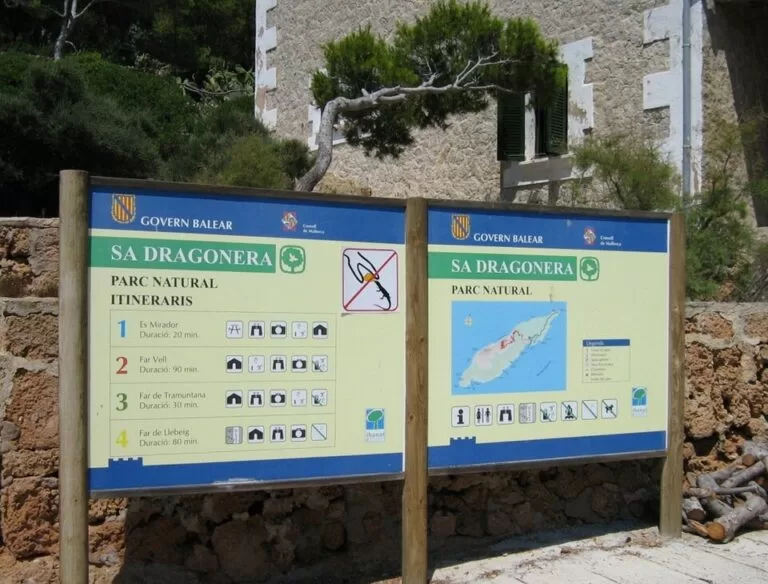
The park has four signed walking routes, all starting near the pier (Balearic government):
- Na Miranda: a short climb to a viewpoint; OpenStreetMap puts it about 200 m from the pier in a straight line.
- Far de Tramuntana: to the lighthouse at the north-east end, about 1.4 km away in a straight line.
- Far Vell: up to the old lighthouse on Na Pòpia, about 1 km away in a straight line but well above the sea.
- Far de Llebeig: the longest, to the lighthouse at the south-west tip, about 2.6 km away in a straight line.
The routes are simple but steep in places, with shaded rest areas, a bird hide and viewpoints.
The island is geologically the western end of the Serra de Tramuntana. The park counts 361 plant species, 18 found only in the Balearics. You will meet the Lilford’s wall lizard (Podarcis lilfordi), here in one of its largest populations; do not feed them. The park leaflet says the island has the largest Eleonora’s falcon colony in the Balearics.
In 1977 young activists occupied the island to stop a building plan, and in 1979 thousands marched in Palma to “Save Sa Dragonera”. The Consell de Mallorca bought it in 1987, and it became a natural park in 1995.
Practical details
Visiting hours, from the Balearic government page (checked November 2026):
- 1 May to 31 October: 10:00–16:30 on weekdays, and 10:00–18:00 on Saturdays, Sundays and public holidays.
- 1 November to 30 April: 10:00–14:30.
- Information centre: 10:00–16:30 from May to October, 10:00–14:30 from November to April.
- The park is open every day of the year, except when the weather stops the boats.
Rules and tips:
- Bring all the water you need. There is no drinking water on the island, and the tap water in the toilets is not safe to drink. Drinks are only sold on the tourist boats.
- Swimming is allowed at Cala Lledó if you come by tourist boat. Bring a mask: the park points to the seagrass meadows and fish. Watch for jellyfish and anemones.
- Snorkelling and free diving are allowed in the park’s waters; scuba diving needs a permit.
- The islets Es Pantaleu and Sa Mitjana are reserves, and landing there is forbidden.
- Stay on the marked paths. No pets, no fires and no camping; sports other than walking are not allowed (park leaflet).
- You cannot stay overnight.
- Exempt from the €1 fee: Mallorca residents on Saturdays, under-14s, over-65s and authorised school or group visits.
Accessibility and safety
The park says plainly that it has no adapted access: the pier, the boats and the paths are not suitable for wheelchairs, and it does not recommend the visit for people with reduced mobility. Depending on the person, a visit with help may be possible: the Balearic natural areas service lends Joëlette all-terrain chairs, with Red Cross volunteers, on request and subject to availability (tel. 638 58 21 45). The paths have little shade and summer heat is strong, so take a hat, sun cream and plenty of water.
Best time to visit
Spring and autumn, says the park, because the paths have little shade and summers are hot. April and October are the peak of bird migration. In winter the day ends at 14:30 and boats depend on the weather.
Nearby alternatives
- Serra de Tramuntana, 42 km away: the mountain range that Sa Dragonera closes at its western end.
- Palma Cathedral (La Seu), 28 km away: the Gothic cathedral on Palma’s seafront, on the way to or from the airport.
- Torrent de Pareis, 53 km away: a hard canyon walk in the north of the Tramuntana.
- Cabrera Island, 73 km away: Mallorca’s other protected island, a national park reached by boat from Colònia de Sant Jordi.
Distances are in a straight line from the island.
FAQ
How do I get to Sa Dragonera?
By boat. The most frequent boats leave from the pier at Sant Elm (Andratx), normally from March to October; others run from Port d’Andratx and Santa Ponça. All visitors land at the Cala Lledó pier.
Do you need a ticket or permit to visit Sa Dragonera?
No permit for individuals or small groups: entry is free, and tourist-boat passengers pay a €1 park fee through the boat company. Groups of more than 10 people need prior authorisation from the park.
Is there parking in Sant Elm for the Dragonera boat?
Yes. OpenStreetMap shows a paid car park for about 70 cars some 400 m from the pier, and free parking areas 300–530 m away. You can also come on TIB bus line 100 from Palma.
Can you swim at Sa Dragonera?
Yes, at Cala Lledó, next to the landing pier, if you come on a tourist boat. It is a small cove with seagrass meadows that is good for snorkelling.
When is the best time to visit Sa Dragonera?
Spring and autumn, says the park, because the paths have little shade. April and October are best for bird migration.
Sources and freshness
Checked 6 November 2026 · 3 sources Show
Checked 6 November 2026. Official: Balearic government, Parc Natural de Sa Dragonera (size, history, access, boats, hours, fee, rules, accessibility, routes, facilities) and its English park leaflet (rules, Eleonora’s falcon, 274 ha). Location, pier, car parks, bus stops, lighthouses and distances: OpenStreetMap contributors (ODbL). Photos: Wikimedia Commons, licences as credited. Boat fares and timetables were not checked: ask the boat companies in Sant Elm.
This place is part of our Balearic Islands travel guide: Mallorca, Menorca, Ibiza and Formentera — see every town, beach and cove we have mapped on that coast.
How this page is made. CostaMap is written with an AI editorial system run by Ebizapple. This page is based on the sources listed above. Last updated 6 November 2026. Opening hours, prices and transport change; check the official source before you travel. How we work · Partner links and ads