
Playa El Palmar (Vejer de la Frontera)
BeachPlaya El Palmar, also called El Palmar de Vejer, is a long, straight Atlantic surf beach in the municipality of Vejer de la Frontera (Cádiz), about 10 km west of the hill town and 6.6 km south of Conil. You reach it by car on local roads off the A-48, or by bus on the Bahía de Cádiz network, and park in paid dirt car parks behind the sand. Spain’s official tourism portal lists 3,300 m of golden sand with a surf zone, toilets and showers; behind it are campsites, camper parks and beach bars rather than apartment blocks. It suits surfers, campers and anyone who wants a big open beach; skip it if you need shade, calm water or a promenade.
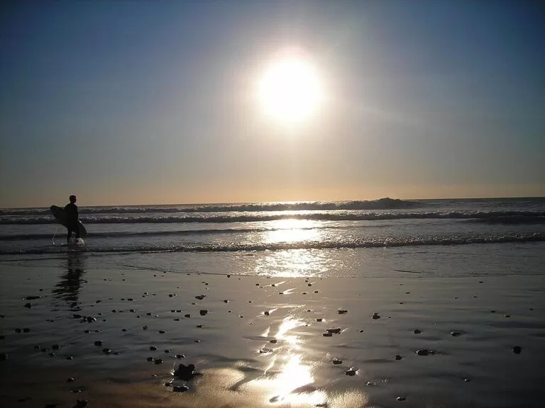
Quick facts
- Names: Playa de El Palmar, Playa El Palmar or El Palmar de Vejer (Spanish playa is beach). Not to be confused with El Palmar near Valencia.
- Where: El Palmar, municipality of Vejer de la Frontera (Cádiz), Costa de la Luz, between Conil de la Frontera to the north and Los Caños de Meca to the south.
- Coordinates: 36.2211, -6.0641.
- Size: 3,300 m long and 50 m wide (spain.info). The sand mapped on OpenStreetMap runs for about 4.7 km.
- Surface: golden sand.
- Water: moderate waves and windy (spain.info).
- Facilities: toilets, showers, litter bins, cleaning, telephone and a surf practice zone (spain.info).
- Landmark: the Torre Nueva, an old defensive tower near the beach.
- Entry: free.
Access and parking
By car: spain.info names the A-48 as the nearest main road and lists easy access by car and on foot. From the A-48 local roads lead down to El Palmar; the beach road runs parallel to the sand.
Parking: OpenStreetMap maps a row of paid, unpaved car parks behind the beach, about 1 to 1.4 km from our map point, plus a small free car park with disabled spaces further along. We could not confirm 2026 parking prices.
Campers: two camper parks are mapped near the beach. Caravan Área El Palmar Beach is tagged with 158 places at 20 EUR a night, or 14.80 EUR from 15 September to 15 June, with power at 5 EUR extra; Nomada El Palmar is tagged with 77 places at 12 EUR. These are mapped figures, not official prices (checked November 2026), so check with the operator.
By bus: OpenStreetMap shows a sheltered stop called El Palmar de Vejer, about 500 m from the beach, on the Consorcio Metropolitano de Transportes de la Bahía de Cádiz network, and further stops at Camino de la Playa. Check the consortium timetable before you travel.
What to expect
A long, open strip of sand facing the Atlantic. On OpenStreetMap the beach front is lined with small buildings, beach bars and restaurants, campsites (such as Camping El Palmar) and camper areas, but no high-rise blocks. spain.info rates it as semi-urban with medium occupancy, and notes that most of the accommodation is campsites and apartments next to the beach, where many of the windsurfers who come here stay.
El Palmar is above all a surf beach. spain.info lists a surf practice zone and moderate waves, and the beach faces the open Atlantic. On calm summer days the sea can be gentle near the shore, but the beach is exposed to wind and waves, so conditions change from day to day.
The Torre Nueva, mapped on OpenStreetMap as a defensive tower, stands near the beach about 1.4 km from our map point, close to the camper areas. It makes an easy landmark for meeting up.
Practical details
- Surf: a surf practice zone is listed by spain.info. If you are a beginner, book a lesson with a licensed school.
- Food: about twenty places to eat and drink are mapped within 2 km, most of them along the beach road.
- Shade: there is none on the sand; bring a hat, water and a windbreak.
- Nearest marina: Puerto de Conil, 15 km away (spain.info).
- Drinking water: a fountain is mapped near the bus stop.
Accessibility and safety
El Palmar is an exposed Atlantic beach with moderate waves and wind (spain.info). Swim only where the flags allow and keep clear of surfers. We could not confirm the 2026 lifeguard season or hours. A small free car park with disabled spaces is mapped behind the beach, but we could not confirm a step-free walkway or amphibious chair down to the water.
Best time to visit
For surfing, the swell matters more than the month: check a surf forecast before you go. For a beach day, late spring and September are warm and much quieter than August. In July and August parking and the camper areas fill, so arrive in the morning. Sunsets over the open sea are a reason to stay into the evening.
Nearby alternatives
- Cabo de Trafalgar, 5.1 km away: the cape and lighthouse to the south.
- Los Caños de Meca, 5.3 km away: the beaches beyond the cape.
- Conil de la Frontera, 6.6 km away: the white town and fishing port to the north.
- Playa de la Fontanilla, 7.4 km away: Conil’s town beach.
- Vejer de la Frontera, 9.8 km away: the hill town the beach belongs to.
Distances are in a straight line from the beach.
FAQ
How do I get to El Palmar beach?
By car via the A-48 and local roads to El Palmar, or by bus on the Bahía de Cádiz consortium network, which has a stop about 500 m from the sand.
Is there parking at El Palmar?
Yes. Paid, unpaved car parks line the road behind the beach, with a small free car park further along. In summer they fill early.
Is El Palmar good for surfing?
Yes. spain.info lists a surf practice zone, and the beach is exposed to Atlantic swell. Beginners should go with a surf school.
Can you swim at El Palmar?
Yes, on calm days, but it is often windy with moderate waves. Swim where the flags allow and away from surfers.
Can I stay overnight in a camper van?
Use one of the two camper parks mapped close to the beach, or a campsite behind it; we could not confirm local rules on overnight parking elsewhere.
Sources and freshness
Checked 6 November 2026 · 2 sources Show
Checked 6 November 2026. Official: spain.info, Playa El Palmar (Vejer de la Frontera) (size, sand, waves, services, road, occupancy, accommodation, marina). Location, car parks, camper parks and tagged charges, bus stops, Torre Nueva and distances: OpenStreetMap contributors (ODbL). The Vejer town hall and tourist office websites could not be reached from our research tools. Photos: Wikimedia Commons, licences as credited.
This place is part of our Costa de la Luz, Spain: beaches, towns, sherry and map — see every town, beach and cove we have mapped on that coast.
How this page is made. CostaMap is written with an AI editorial system run by Ebizapple. This page is based on the sources listed above. Last updated 6 November 2026. Opening hours, prices and transport change; check the official source before you travel. How we work · Partner links and ads