
Talaia d’Albercutx walk (Formentor, Mallorca)
Hiking trailThe Talaia d’Albercutx walk climbs to a 16th-century watchtower on a hilltop above the Formentor peninsula in Pollença, in the north of Mallorca. It starts at the Mirador d’es Colomer viewpoint on the Formentor road (Ma-2210), where there is a bus stop and a free car park, and follows a narrow paved road for about 2 km to the tower, which stands at around 370–390 m. It suits walkers who want a short climb with wide views over Cap de Formentor; skip it if you are looking for a shaded forest path or a route away from any road.
Quick facts
- Names: Talaia d’Albercutx (also spelt Albercuix), also called Talaia Major de Pollença or Talaia de Formentor. In Spanish it is the Atalaya de Albercutx. The starting viewpoint is the Mirador d’es Colomer; the official tourism site calls the viewpoint here the Mirador de sa Creueta.
- Where: on the Formentor peninsula, municipality of Pollença, Mallorca.
- Coordinates of the tower: 39.9288, 3.1172.
- Height: 390 m according to Catalan Wikipedia; OpenStreetMap marks the summit at 370 m.
- Distance: about 1.9 km one way from the Mirador d’es Colomer to the summit, so roughly 4 km there and back (measured on OpenStreetMap).
- Height gain: no official figure. OpenStreetMap puts the Coll de la Creueta, next to the viewpoint, at 207 m, which means a climb of roughly 165–185 m to the top.
- Surface: asphalt for almost the whole way, with a short cut on steps and path, and a paved path at the end.
- Built: around 1595. Listed as a Bé d’Interès Cultural (protected heritage site) since 30 November 1993.
- Entry: free. The tower is publicly owned and can be visited freely (Catalan Wikipedia).
Access and parking
By car: drive from Port de Pollença towards Formentor on the Ma-2210. The Mirador d’es Colomer is about 3.4 km from the edge of Port de Pollença by road (OpenStreetMap). The official Balearic tourism site calls the Formentor road winding and steep (illesbalears.travel). Access rules for private cars on this road can change in summer; we could not open the Consell de Mallorca site, so check current rules before you set off.
Parking: OpenStreetMap shows a free surface car park right by the viewpoint and a second free one about 185 m further along the road. It also maps a small free car park about 120 m below the summit, at the end of the summit road. We could not confirm whether private cars are allowed up that road.
By bus: OpenStreetMap shows two bus stops called Mirador d’es Colomer (Formentor), run by the Consorci de Transports de Mallorca, with line 334 between Alcúdia and Formentor mapped through here. We could not confirm the timetable or the season it runs in.
On foot from Port de Pollença: the shortest route on OpenStreetMap is about 5.3 km each way, but the first 3 km follow the Ma-2210 road itself.
The route
From the viewpoint, take the narrow paved road that climbs south-east, mapped on OpenStreetMap as the camí de la talaia d’Albercutx. Catalan Wikipedia says this road was built by Republican prisoners from the Albercutx camp, near the old farm buildings of the estate (Wikipedia). After about 950 m a short flight of steps and a path cut off a bend. Rejoin the road and follow it to the end, where a paved path leads up to the tower.
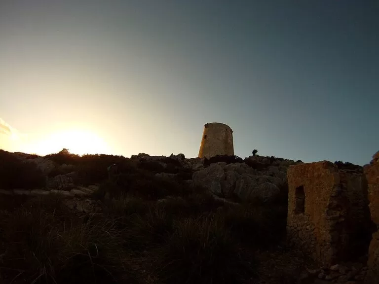
Near the top you pass a small military battery and a recent helicopter pad, built a few metres below the tower. Next to the tower are the ruins of the one-room hut where the watchmen lived.
What to expect at the top
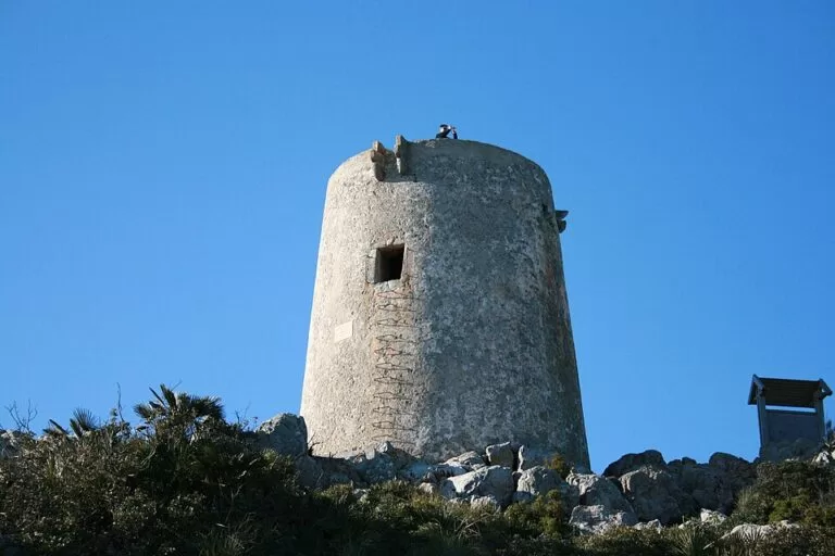
A round, slightly tapering tower of stone and mortar. According to Catalan Wikipedia, the lower half is solid and the single room sits about four metres up; the watchmen climbed to it on a rope ladder with wooden rungs. Inside, the vaulted room still shows drawings of aeroplanes from the 1940s, when the tower was used as an observation post. A hole in the vault leads to the roof terrace.
The tower was a lookout, not a fort. It had no artillery: its job was to watch the sea and pass warnings to the tower at Alcúdia. Pollença asked for it in 1577, after the town was raided in 1550 by corsairs led by Dragut, and it seems to have been built around 1595. It served as an observation post during the Spanish Civil War until 1943, was nearly pulled down in 1972 to make room for an artillery battery, and came into the town’s ownership after Pollença blocked a 1983 plan to demolish it for a radio beacon.
Wikipedia describes views that take in the whole of Cap de Formentor.
Practical details
- We found no facilities at the summit. Bring water and sun protection.
- The road is narrow, so walk in single file and watch for vehicles.
- Take your rubbish home and do not climb on the walls of the ruins.
- For a swim afterwards, Formentor beach (Cala Pi de sa Posada) is further along the road; illesbalears.travel lists hammocks, umbrellas, a small bar and a paid car park about 400 m from the sand.
Accessibility and safety
The route is mostly on a paved road but includes steps, a short path and rocky ground around the tower. It is not suitable for wheelchairs. Iron rungs lead up the tower wall; we could not confirm whether climbing them is permitted or safe, so stay on the ground if in doubt. Keep children away from the edges of the summit. In an emergency call 112.
Best time to visit
Go early in the morning or late in the afternoon for softer light and fewer cars at the viewpoint. In midsummer the climb is exposed to the sun, so cooler months are more comfortable.
Nearby alternatives
- Mirador Es Colomer, 0.5 km away: the viewpoint at the start of the walk.
- Torrent de Pareis, 26 km away: Mallorca’s best-known gorge walk, down to Sa Calobra.
- Serra de Tramuntana, 36 km away: the mountain range of north-west Mallorca, with many more walks.
- Port de Sóller, 39 km away: harbour town on the west coast, with boats along the cliffs.
Distances are in a straight line from the tower.
FAQ
How do you get to the Talaia d’Albercutx?
Start at the Mirador d’es Colomer on the Ma-2210 Formentor road and walk up the paved road to the tower, about 1.9 km each way.
Is there parking for the Talaia d’Albercutx walk?
Yes. OpenStreetMap shows a free car park at the Mirador d’es Colomer and another 185 m along the road.
How high is the Talaia d’Albercutx?
Catalan Wikipedia gives 390 m; OpenStreetMap marks the summit at 370 m.
Can you go inside the tower?
The tower is publicly owned and can be visited freely, according to Catalan Wikipedia. The room is about four metres above the ground; we could not confirm current access to it.
Can you get there by bus?
OpenStreetMap shows bus stops at the Mirador d’es Colomer, served by line 334 between Alcúdia and Formentor. Check the timetable with the Consorci de Transports de Mallorca.
Sources and freshness
Checked 6 November 2026 · 3 sources Show
Checked 6 November 2026. Official: Balearic Islands tourism, Formentor beach (road, Mirador de sa Creueta, beach services and parking). Background and history: Catalan Wikipedia, Talaia d’Albercutx (height, construction, heritage listing, the summit road, ownership). Route, distances, spot heights, parking and bus stops: OpenStreetMap contributors (ODbL). The Consell de Mallorca and Pollença town hall sites could not be opened, so we have no official walking time or current road access rules. Photos: Wikimedia Commons, licences as credited.
This place is part of our Balearic Islands travel guide: Mallorca, Menorca, Ibiza and Formentera — see every town, beach and cove we have mapped on that coast.
How this page is made. CostaMap is written with an AI editorial system run by Ebizapple. This page is based on the sources listed above. Last updated 6 November 2026. Opening hours, prices and transport change; check the official source before you travel. How we work · Partner links and ads