
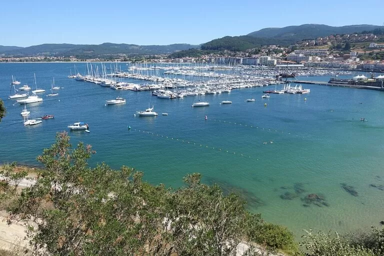
Baiona is a small walled port town at the southern mouth of the Ría de Vigo, where the caravel La Pinta landed on 1 March 1493 with the first news of Columbus’s voyage. Its two big sights sit side by side on the seafront: the Monterreal fortress, whose 3 km of walls now enclose a state-run parador hotel, and a life-size replica of La Pinta moored in the harbour as a museum. You can drive or take the bus, and park in the town’s car parks by the promenade. It suits history lovers, walkers and anyone heading for the Cíes Islands by boat; skip it if you want a quiet beach village in August.
Quick facts
- Names: Baiona in Galician and officially; Bayona in Castilian. The fortress is the Fortaleza (or Castelo) de Monterreal, on the Monte Boi peninsula.
- Where: southern shore of the mouth of the Ría de Vigo, Pontevedra province, next to Cape Silleiro (spain.info).
- Coordinates: 42.1215, -8.8502 (tourist office on the Paseo Ribeira).
- Fortress: 3 km of defensive walls with towers and gates, built between the 11th and 17th centuries; bought by the Ministry of Tourism in 1963 and a parador hotel since 1966 (turismo.gal guide).
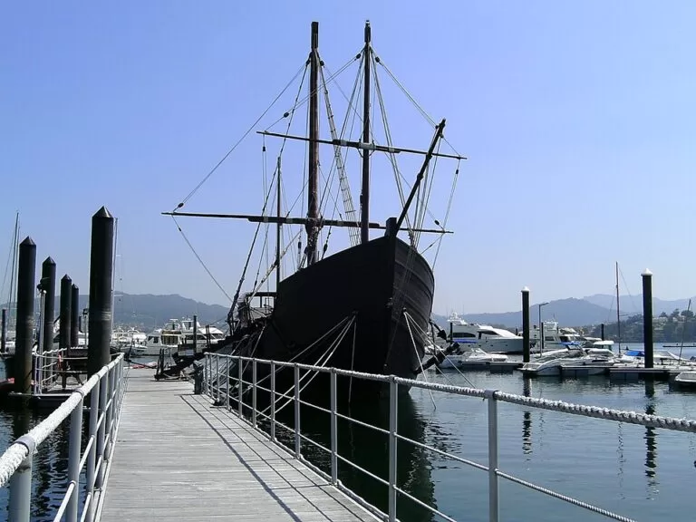
- La Pinta: arrived on 1 March 1493. The replica was built in A Guarda for the fifth centenary and is now a museum (turismo.gal guide).
- Old town: declared a site of historical and artistic interest in 1993.
- Main festival: Festa da Arribada, first weekend of March, of international tourist interest.
Access and parking
By car: the official walking guide starts at the Parador Conde de Gondomar inside the fortress, which it says can easily be reached by car or bus, with a public car park close by (turismo.gal, “Baiona: a walk of history and life”). OpenStreetMap shows a paid underground car park, Aparcadoiro da Palma, under the promenade by the tourist office, and several surface car parks on the Monterreal peninsula; some of those are marked for customers only (OpenStreetMap). We could not confirm current prices.
By bus: OpenStreetMap shows the Baiona stop of the ATSA / Lugove coach lines at the southern end of the promenade. We could not confirm timetables.
By boat: catamarans for the Cíes Islands leave from the passenger terminal at the port, on Avenida de Monterreal.
On foot: the town is on the Portuguese Coastal Way to Santiago de Compostela, and pilgrims pass along rúas Porta da Vila and O Mariñeiro.
What to see
Monterreal fortress. The walls run round the Monte Boi peninsula, where there are traces of Roman occupation. Drake and the Duke of Lancaster attacked the town, and Philip II stationed up to 17,000 soldiers here, calling Baiona the “key to his kingdoms”. Along the walls you pass the Torre del Reloj (clock tower, used as a lookout), the Torre de la Tenaza (once a prison) and the Torre del Príncipe, a source of legends about an iron mask. The official guide recommends the walk along the ramparts for its views of the port, the beaches and the Cíes Islands. Outside the walls, the Monte Boi promenade, almost 2 km long, runs past the beaches of A Cuncheira, Os Frades, A Barbeira and A Ribeira (turismo.gal). At the foot of the fortress stands a granite sculpture group, Encounter between two worlds, for the fifth centenary.
La Pinta replica. A short walk from the promenade, the life-size replica shows the hard living conditions on board, the navigation instruments of the time and the first products that came from the Americas, such as maize, tobacco, cotton and peanuts. OpenStreetMap places it at the pier near the tourist office, about 260 m east. On the Paseo Ribeira, the arches hold the Pozo de la Aguada well, the 180-piece Arribada tile showing the return routes of La Pinta and La Niña, and a plaque with the names of the 26 crew.
Old town. Narrow cobbled streets with arcades and balconies lead to the late 17th-century chapel of Santa Liberata and the former collegiate church of Santa María, built between the 12th and 14th centuries in plain Cistercian style. Other stops on the official route: the round 16th-century Dominican convent, where the nuns sell almond biscuits; the 17th-century Fonte de Zeta; the Calvary of the Santísima Trindade, more than 500 years old; and the Casa de la Navegación museum on the town’s links with the sea. The tapas streets are rúa Ventura Misa and rúa O Conde. The fish market holds a public auction every day at five in the afternoon.
Practical details
- Tickets: we could not confirm current prices or hours for the Pinta replica or the Casa de la Navegación; ask at the tourist office on the Paseo Ribeira.
- Fortress grounds: the parador occupies the fortress; we could not confirm whether non-guests pay to enter the grounds or the ramparts walk.
- Toilets: OpenStreetMap shows public toilets on the Paseo Ribeira near the tourist office.
- Festivals: Festa da Arribada (first weekend of March, re-enactment of the landing on Ribeira beach); the Virgen de la Anunciada procession with the Sword Dance in August; the honey and walnut pilgrimage of San Cosme and San Damián on 25–26 September.
Accessibility and safety
The promenade, port and Pinta pier are flat. The old town has cobbles and slopes, and the rampart walk is on old stone and we could not confirm step-free access. Access to the Pinta is over a wooden gangway, and we could not confirm wheelchair access on board. OpenStreetMap maps several disabled parking spaces near the bus stops at the south end of the promenade.
Best time to visit
For the fiesta, go on the first weekend of March, when the town dresses in period costume for the Arribada. For beaches and boats to the Cíes, the season runs from 15 May to 15 September. Spain.info recommends sunset from Monterreal. The seafront Avenida de Monterreal is at its liveliest in summer (turismo.gal).
Nearby alternatives
- Cíes Islands, 12 km north-west across the water: catamarans leave from Baiona port in season.
- Ons Island, 29 km north: the other island group of the national park, reached from the Ría de Pontevedra ports.
Distances are in a straight line from the tourist office.
FAQ
Can you visit the La Pinta replica in Baiona?
Yes. It is a museum showing life on board and the first goods brought back from the Americas. Check prices and hours at the tourist office.
Can you walk the walls of Monterreal?
Yes, the official guide recommends the walk along the ramparts for the views over the bay and the Cíes. There is also a promenade of almost 2 km round the outside of the walls.
Is there parking in Baiona?
Yes. There is a paid underground car park under the promenade and surface car parks near the fortress, some for customers only.
Can you go to the Cíes Islands from Baiona?
Yes. Catamarans leave from the port; in high season you need the free Xunta authorisation first.
When is the Arribada festival?
On the first weekend of March, marking La Pinta’s arrival on 1 March 1493.
Sources and freshness
Checked 6 November 2026 · 3 sources Show
Checked 6 November 2026. Official:
- turismo.gal, “Baiona: a walk of history and life” (walking guide, 2022): fortress, Pinta replica, old town, festivals, port
- spain.info, Baiona (location, walls, sunset)
- Turismo Rías Baixas, Ribeira beach. Background: Galician Wikipedia, Pinta replica. Car parks, bus stop, toilets, tourist office and distances: OpenStreetMap contributors (ODbL). Photos: Wikimedia Commons, licences as credited
How this page is made. CostaMap is written with an AI editorial system run by Ebizapple. This page is based on the sources listed above. Last updated 6 November 2026. Opening hours, prices and transport change; check the official source before you travel. How we work · Partner links and ads