
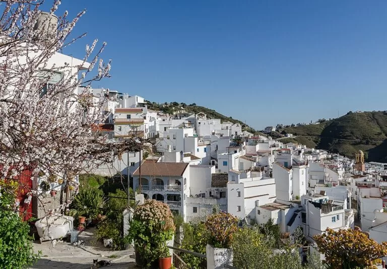
Cómpeta is a white hill village in the Axarquía, Málaga province, at 638 m below the Sierras of Tejeda and Almijara, about 11 km inland from Torrox Costa and 13 km from Nerja in a straight line. You get there by car on mountain roads from the coast, or by bus. It is known for its steep whitewashed streets, the ochre tower of its church, Moscatel wine and raisins, and the Noche del Vino wine festival on 15 August. It suits walkers, people who want a cooler base than the coast, and day-trippers combining it with Frigiliana; skip it if you want a beach on the doorstep or dislike winding roads.
Quick facts
- Name: Cómpeta (often written Competa in English). People from the village are competeños.
- Where: municipality of Cómpeta, La Axarquía, Málaga province, Andalusia; postcode 29754.
- Coordinates: 36.8328, -3.9747 (village centre, OpenStreetMap).
- Altitude: 638 m (andalucia.org).
- Population: 2,681 according to andalucia.org; Spanish Wikipedia gives 3,824 for the municipality (INE 2025). The figures cover different years and areas.
- Area: 54 km² (andalucia.org).
- Distance to Málaga: 53 km by road (andalucia.org); about 50 km in a straight line to Málaga airport.
- Known for: Moscatel grapes, wine and raisins, the Noche del Vino (15 August), walking in the Sierra Almijara.
Getting there and parking
By car: Cómpeta is reached by mountain roads that climb from the coast. Spanish Wikipedia gives 22.4 km to Vélez-Málaga and 51.5 km to Málaga city. The last stretch is narrow and winding. The old centre is steep and its streets are not made for cars: park on the edge.
Parking: OpenStreetMap shows a multi-storey car park and a free surface car park with about 50 spaces on the west side of the centre, and smaller free car parks around Plaza del Carmen and the Plaza de la Vendimia. The Plaza de la Vendimia is used for the Noche del Vino, so expect it to be closed for parking around 15 August. We could not confirm car park fees.
By bus: OpenStreetMap shows two bus stops on the main road below the centre, operated by Loymerbus, a few steps from the tourist office. We could not confirm 2026 routes or times; ask at the tourist office or the bus station in Torre del Mar or Nerja.
What to see
The village: the Andalusian tourist board calls Cómpeta’s townscape one of the most striking in Málaga province. It belongs to a group of former Morisco villages at the foot of the Sierras of Tejeda and Almijara (Árchez, Salares, Sedella, Canillas de Albaida and Canillas de Aceituno) where vines were the main crop and still shape the landscape; together they form the Ruta del Mudéjar (andalucia.org). The centre is Plaza Almijara, with the church beside it.
Church of Nuestra Señora de la Asunción: the parish church on Plaza Almijara, the main monument named by andalucia.org. Spanish Wikipedia describes a late-16th-century church with an ochre tower about 30 m high, rebuilt after the earthquake of 25 December 1884, which brought down the tower and several houses. The ceramic murals on the nearby Plaza de las Tradiciones show traditional crafts.
Museums and viewpoints: OpenStreetMap maps a municipal Museo de Artes y Costumbres near the tourist office, a viewpoint over the hanging houses (Casas Colgantes) on the east side, and the Cruz del Monte above the village. We could not confirm museum opening hours.
History: some authors derive the name from the Latin compita, crossroads. In May 1487, soon after Vélez-Málaga fell to the Catholic Monarchs, the Muslim inhabitants submitted to the Crown. In 1569 Martín Alguacil, a native of Cómpeta, was one of the leaders of the Morisco revolt that ended at the Peñón de Frigiliana; after the expulsion of the Moriscos in 1570 their land was given to settlers from Seville, Baena, Estepa and elsewhere. A cholera epidemic hit the village in summer 1885 (andalucia.org).
Walking and nature
Cómpeta sits below the Sierra Almijara, part of the Sierras of Tejeda, Almijara and Alhama Natural Park. Spanish Wikipedia names La Maroma, 2,065 m, as the highest summit visible from the village, with Cerro Lucero (1,779 m) among the other peaks of the municipality. A signpost by the village marks the GR 249 Gran Senda de Málaga long-distance path, with Frigiliana 25.3 km away on foot (OpenStreetMap). The hamlet of El Acebuchal, in the mountains between Cómpeta and Frigiliana, belongs to the municipality. Mountain walks here are long and exposed: carry water, start early in summer, and check fire-risk restrictions before you set out.
Food and the Noche del Vino
The vine is the backbone of Cómpeta: Spanish Wikipedia names its raisins and its wine, sweet and dry, as what most characterises the village. The Noche del Vino on 15 August grew out of the farm workers’ farewell before they left for the grape harvest. Spanish Wikipedia dates its present form to 1973, when a villager, Aurelio Fernández Navas, offered free wine to everyone in the village for the night. The day starts with grape treading in the Plaza de la Vendimia and a tasting of local Moscatel wine, followed by migas, then music and flamenco on Plaza Almijara into the night. Local dishes named on Spanish Wikipedia include migas, fennel stew (potaje de hinojos) and fried pumpkin.
Practical details
- Tourist office: run by the town hall, on the main road by the bus stops (OpenStreetMap). We could not reach the town hall website to confirm hours.
- Streets: steep, stepped in places and paved with stone. Wear proper shoes.
- Weather: at 638 m it is usually cooler than the coast, and winter evenings can be cold.
Accessibility
The old centre is steep, with steps and narrow lanes. Wheelchair users and people with limited mobility will manage the main road and the area around Plaza Almijara, but not much of the rest. Mountain roads to the village are narrow, with many bends.
Best time to visit
Spring and autumn are best for walking. Late winter brings almond blossom around the village, as in the photo above. The Noche del Vino on 15 August is the busiest night of the year; book a bed early if you want to stay. In July the village holds its fair in honour of San Sebastián (Spanish Wikipedia).
Nearby alternatives
- Frigiliana, 8.5 km away: the best-known white village of the area, above Nerja.
- Sierras of Tejeda, Almijara and Alhama Natural Park, 9.6 km to the park’s reference point: the mountains behind Cómpeta.
- Nerja, 13.3 km away: the nearest large coastal town.
- Balcón de Europa, 13.2 km away: Nerja’s viewpoint over the sea.
- Caves of Nerja, 14.0 km away: the show caves at Maro.
- Playa de Burriana, 13.3 km away: Nerja’s main beach.
Distances are in a straight line from the village centre. For the coast below, see our Axarquía coast and Nerja guide.
FAQ
How far is Cómpeta from the beach?
About 11 km in a straight line to Torrox Costa and 13 km to Nerja. By road it is further, on winding mountain roads.
Is there parking in Cómpeta?
Yes. OpenStreetMap shows a multi-storey car park and a free car park of about 50 spaces on the west side of the centre, plus smaller car parks. Do not drive into the old streets.
When is the Noche del Vino in Cómpeta?
On 15 August each year, with grape treading in the Plaza de la Vendimia during the day and music and flamenco on Plaza Almijara at night.
Can you get to Cómpeta by bus?
Yes, buses stop on the main road below the centre (Loymerbus, according to OpenStreetMap). Check current times locally.
Sources and freshness
Checked 7 November 2026 · 3 sources Show
Checked 7 November 2026. Official: andalucia.org, Cómpeta (Junta de Andalucía tourism: altitude, population, area, distance, Ruta del Mudéjar, church, history). Background: Spanish Wikipedia (church tower, peaks, Noche del Vino, local dishes, July fair, distances by road). Location, car parks, bus stops, tourist office, museum, viewpoints and the GR 249 signpost: OpenStreetMap contributors (ODbL). The Cómpeta town hall website could not be reached when we checked. Photo: Wikimedia Commons, licence as credited.
This place is part of our Costa del Sol travel guide: where it is, towns and beaches — see every town, beach and cove we have mapped on that coast.
How this page is made. CostaMap is written with an AI editorial system run by Ebizapple. This page is based on the sources listed above. Last updated 6 November 2026. Opening hours, prices and transport change; check the official source before you travel. How we work · Partner links and ads