
Sierra Bermeja and Los Reales (Estepona)
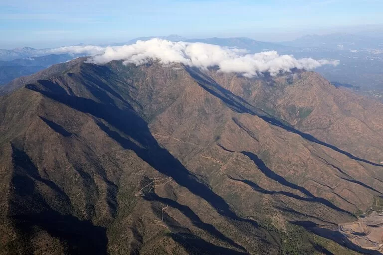
Natural parkSierra Bermeja is the red mountain range behind Estepona, and Los Reales, its highest point at about 1,450 m, is the classic outing: a protected natural area with the only pinsapo fir forest in the world that grows on peridotite rock, and views from the summit over the western Costa del Sol, the Rock of Gibraltar and the coast of North Africa. You drive up from Estepona on the MA-8301 to the Peñas Blancas pass and then take the road to the Los Reales picnic area, where short marked trails start. It suits walkers, birdwatchers and anyone who wants a cool, high viewpoint a short drive from the beach; skip it if you want a long, shaded hike in midsummer or have no car.
Quick facts
- Names: Paraje Natural Los Reales de Sierra Bermeja in Spanish (Los Reales, Pico de los Reales). Bermeja means vermilion, after the colour of the rock.
- Where: the south-west edge of the Serranía de Ronda, above Estepona and Casares in Málaga province. The protected area covers parts of the municipalities of Casares, Estepona and Genalguacil (Wikipedia, Spanish).
- Coordinates (Los Reales summit): 36.4845, -5.2085 (OpenStreetMap).
- Height: Andalucía’s tourist board gives 1,450 m for Los Reales and an average height of the range of about 1,000 m; Spain.info gives 1,449 m, Wikipedia (Spanish) 1,452 m and OpenStreetMap 1,440 m.
- Protection: Paraje Natural since 1989, Special Protection Area for birds since 2002 and Special Area of Conservation in the Natura 2000 network since 2013 (Wikipedia, Spanish).
- Size: 1,236 ha (Wikipedia, Spanish).
- Entry: free; OpenStreetMap marks the trailhead and the mountain hut at Los Reales as free of charge.
Access and parking
By car: from Estepona take the MA-8301, the mountain road that climbs north towards Jubrique, to the Puerto de Peñas Blancas, a pass at about 765 m (OpenStreetMap). From the pass a narrow asphalt road runs west along the ridge to the Los Reales recreation area. In a straight line the recreation area is about 7.7 km from Estepona town centre, but the road is much longer and winding; allow for slow driving.
Parking: OpenStreetMap shows several small car parks at the end of the road by the Los Reales picnic area and the trailhead, and another car park at Peñas Blancas by the Fuente Arroyo Abrón spring. Their size is not stated; at weekends with good weather, arrive early.
Without a car: we found no public bus to Los Reales. The PR-A 164 footpath climbs from Estepona to Los Reales (7.1 km in OpenStreetMap), a long and steep walk for fit hikers only.
What to expect
Andalucía’s tourist board describes Los Reales as a great amphitheatre of the Betic ranges that dominates the Costa del Sol from Marbella to Estepona. The range is made of peridotite, an igneous rock from deep in the Earth that is rich in iron and gives the mountain its garnet-red colour; the tourist board calls it one of the largest outcrops of this rock in the world and, with part of the Sierra de las Nieves, the most important place to see intrusive rocks in the inner zones of the Betic Cordillera. Few plants can grow on this soil, which is why the area has so many endemic species (Wikipedia, Spanish).
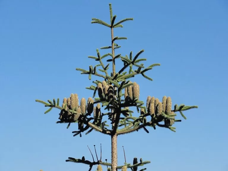
The star is the pinsapo, the Spanish fir. Los Reales holds the only pinsapo forest on peridotite, alongside maritime pine, cork oak, juniper and kermes oak. Higher up there are mountain shrubs such as the aulaga morisca and piorno; lower down dwarf palm, lavender and rosemary. Andalucía’s tourist board counts up to 50 rare or endangered plants, among them Staehelina baetica.
For birdwatchers, the list includes golden, Bonelli’s and booted eagles, peregrine falcon, griffon vulture, sparrowhawk and eagle owl. Ibex, roe deer, genet, Egyptian mongoose and wildcat also live here (Andalucía’s tourist board).
What you can do at the top, according to OpenStreetMap:
- Los Reales picnic area: tables, an information board and the Refugio Agustín Lozano mountain hut, with the Venta El Refugio restaurant next to it.
- SL-A 168, Subida al Pico Los Reales: a 1.8 km local trail run by Estepona town hall from the picnic area to the summit, past the Los Reales radio masts.
- Paseo de los Pinsapos: a mountain path through the fir forest on the north side of the ridge.
- Mirador de Salvador Guerrero: a viewpoint just south of the picnic area.
- PR-A 164, Estepona – Los Reales: the long footpath up from the coast.
Spain.info says the summit gives views over the western Costa del Sol, the Rock of Gibraltar and the north coast of Africa. Clouds and fog often form here, because humid air comes in from both the Atlantic and the Mediterranean (Wikipedia, Spanish), so the view is not guaranteed.
The 2021 fire
In September 2021 a forest fire in Sierra Bermeja stayed active for 46 days; almost 3,000 people were evacuated, close to 8,000 ha were affected and a forest firefighter died. A new fire in June 2022 forced another 2,500 to 3,000 people to leave their homes (Wikipedia, Spanish). Expect burnt slopes on parts of the range. We could not confirm whether every trail described above is open and signposted in 2026; ask at the Estepona tourist office before you go.
Practical details
- Food and water: the Venta El Refugio restaurant at the picnic area (OpenStreetMap; opening days not confirmed) and drinking water at the Fuente Arroyo Abrón by Peñas Blancas. Bring your own water for the trails.
- Information: the Estepona municipal tourist office in the old town (Andalucía’s tourist board).
- Cycling: OpenStreetMap shows signed mountain-bike routes from Peñas Blancas to Los Reales and to Jubrique.
- Weather: it is much cooler and wetter than on the coast. Rainfall at the Los Reales station can pass 1,100 mm a year (Wikipedia, Spanish). Take a layer even in summer.
Accessibility and safety
The picnic area and the nearest viewpoint are reached by car on asphalt, but the trails are dirt mountain paths, not suitable for wheelchairs or pushchairs. The road is narrow and twisting with steep drops; drive slowly. Forest fires are a recurring risk here: Sierra Bermeja had 31 forest fires between 1956 and 2022, 16 of them over 500 ha (Wikipedia, Spanish). Never light a fire or barbecue outside the authorised places and follow any closure notices in summer. Dogs, drones and camping rules for the Paraje Natural could not be confirmed.
Best time to visit
Spring and autumn give the clearest walking weather and the best chance of seeing Gibraltar and Africa. In summer go early in the morning, before the heat and the haze. In winter the summit can be cold, foggy and windy. Avoid days with high fire risk in summer and any day after heavy rain, when the dirt paths are slippery.
Nearby alternatives
- Estepona, about 9 km away: the town below, with its flower-filled old town, La Rada beach and the tourist office.
- Casares, about 7 km away: the white hill village whose municipality shares Los Reales.
- Puerto Deportivo de Estepona, about 9 km away: the marina and fishing port, with boat trips towards the Strait.
- Selwo Aventura, about 11 km away: the animal park in the hills east of Estepona.
- Sierra Blanca, about 29 km away: Marbella’s limestone mountain, further east along the coast.
Distances are in a straight line from the Los Reales summit (OpenStreetMap).
FAQ
How do I get to Los Reales de Sierra Bermeja?
By car from Estepona: take the MA-8301 up to the Puerto de Peñas Blancas, then the asphalt road west to the Los Reales picnic area, where you park.
How high is Los Reales?
About 1,450 m. Sources differ slightly: 1,450 m (Andalucía’s tourist board), 1,449 m (Spain.info) and 1,452 m (Wikipedia, Spanish).
How long is the walk to the summit?
The SL-A 168 trail from the picnic area to the summit is 1.8 km (OpenStreetMap). The PR-A 164 from Estepona is 7.1 km and climbs from sea level.
What is special about Sierra Bermeja?
Its red peridotite rock, one of the largest outcrops in the world, and the only pinsapo fir forest that grows on this rock, with many rare endemic plants.
Was Sierra Bermeja damaged by the 2021 fire?
Yes. The September 2021 fire burned for 46 days and affected close to 8,000 ha of the range (Wikipedia, Spanish). Check trail conditions locally before you go.
Sources and freshness
Checked 7 November 2026 · 7 sources Show
Checked 7 November 2026. Official: Andalucía’s tourist board on Los Reales de Sierra Bermeja, the Estepona tourist office and Estepona; Spain.info on Estepona. Background: Wikipedia (Spanish) on Los Reales de Sierra Bermeja and Sierra Bermeja. Map data: OpenStreetMap (MA-8301, Peñas Blancas, car parks, trails SL-A 168 and PR-A 164, hut, viewpoint and distances). Not confirmed: trail state after the 2021 fire, restaurant opening days, car park size, rules for dogs and drones.
This place is part of our Costa del Sol travel guide: where it is, towns and beaches — see every town, beach and cove we have mapped on that coast.
How this page is made. CostaMap is written with an AI editorial system run by Ebizapple. This page is based on the sources listed above. Last updated 6 November 2026. Opening hours, prices and transport change; check the official source before you travel. How we work · Partner links and ads