
Playa de l’Almardà (Sagunto)
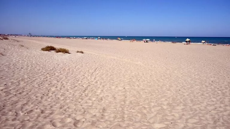
BeachPlaya de l’Almardà is a 1,650 m beach of sand and pebbles in the municipality of Sagunto, on the coast about 7 km east of the old town and 30 km north of València. You reach it by car from the N-340 or AP-7, or by bus, and a protected line of dunes separates the sand from the houses behind (Comunitat Valenciana). It suits families and anyone who wants a quieter, more natural beach than the busy Port de Sagunt seafront, with lifeguards and a beach bar in summer. Skip it if you want soft fine sand all the way to the water or a lively promenade: it is a semi-urban beach with coarse sand and stones.
Quick facts
- Name: Platja de l’Almardà in Valencian, Playa de Almardá in Spanish. Almardà is also the name of the residential district behind it.
- Where: Sagunto (Camp de Morvedre), province of Valencia, between the Corinto and Malvarrosa beaches to the north and the beach of Canet d’en Berenguer to the south.
- Coordinates: 39.6986, -0.1983 (OpenStreetMap).
- Size: 1,650 m long and 100 m wide (Turisme Comunitat Valenciana). Spanish Wikipedia calls it almost two kilometres long.
- Sand: sand and pebbles; the official services list says coarse sand.
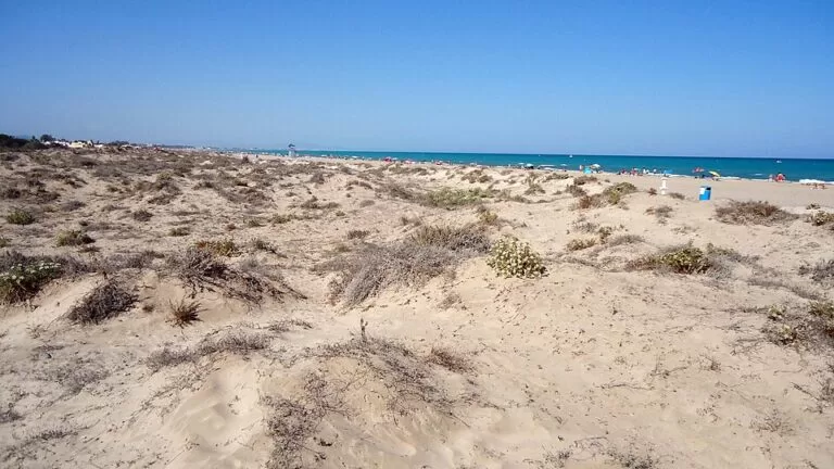
- Type: semi-urban, open beach backed by a dune cordon.
- Awards listed: Blue Flag, Q for Tourist Quality, ISO 14001, ISO 9001, EMAS and an accessibility label (Turisme Comunitat Valenciana). Flags are renewed every season, so check the current one.
- Lifeguards: 15 June to 15 September (Turisme Comunitat Valenciana, checked November 2026).
- Tourist information: Tourist Info Sagunto, tel. 962 65 58 59.
Access and parking
By car: Turisme Comunitat Valenciana suggests the N-340 or the AP-7. Locally, the Avinguda d’Europa runs behind the beach through Almardà to Corinto (OpenStreetMap). OpenStreetMap shows a free surface car park on the beach side of the district, about 800 m south-west of the centre of the beach, a second car park beside it and street parking at the north end near Corinto. The official page lists a car park among the beach services.
By bus: the official page says it is easier to come on foot or by bus than by car. OpenStreetMap maps two sets of stops along the Avinguda d’Europa: the Metrobús stops of the València transport authority (ATMV), named “Sagunt, Almardà, Europa…”, and the stops of the Sagunto urban bus run by AVSA. We could not confirm line numbers or timetables.
By train: Sagunt station is about 6.8 km away in a straight line; from there you need a bus or a taxi.
On foot: Almardà is a residential area, and paths cross the dunes from the streets to the sand. The marina of Port Siles in Canet d’en Berenguer, which the official page names as the nearest port, is about 2.8 km south along the coast.
What to expect
The beach is a long, straight strip between the sea and a dune cordon. Turisme Comunitat Valenciana describes the dunes as an environmental area home to many plants and animals, which everyone is asked to protect, and Spanish Wikipedia calls them of great ecological value. Behind the northern end lies a small wetland, the Marjal d’Almardà, mapped on OpenStreetMap.
The sand is mixed with pebbles, and the beach is semi-urban: houses and low apartment blocks sit behind the dunes rather than on the sand. In summer there is a chiringuito (beach bar), a children’s playground, parasol and lounger hire, and restaurants in the streets behind. Windsurfing is listed among the beach activities.
North of Almardà the coast continues as Corinto and Malvarrosa beaches, which together run for 3,200 m with dunes and a low number of visitors; Malvarrosa has an area where nudism is practised and a campsite behind it (Corinto, Malvarrosa). South of it is Racó de la Mar, the 1,250 m Blue Flag beach of Canet d’en Berenguer (Comunitat Valenciana).
Practical details
- Services: lifeguards in season, toilets, foot showers, walkways, a playground, parasol and lounger hire, a beach bar and nearby restaurants (official services list). OpenStreetMap maps free showers and foot showers at the northern end and a seasonal lifeguard tower near the south.
- Camping: not permitted on the beach.
- Health: OpenStreetMap shows a pharmacy and the public Consultori Auxiliar Almardà (a local health clinic) in the district.
- Prices: we could not confirm prices for loungers or parasols.
- Dogs: we found no official dog rule for this beach; do not assume dogs are allowed in summer.
Accessibility and safety
Turisme Comunitat Valenciana says the beach is accessible to people with reduced mobility and lists walkways and access for people with reduced mobility. Pebbles and coarse sand make walking barefoot uncomfortable, so water shoes help. Swim only when lifeguards are on duty and follow the flags: green is normal, yellow means caution and red means no swimming.
Keep off the dunes: cross only on the marked paths and walkways. The dune cordon is what protects the beach and the houses behind it, and its plants are easily destroyed.
Best time to visit
June to September for swimming with lifeguards (15 June to 15 September). July and August are the busiest months, but the beach is less crowded than the urban beach of Port de Sagunt. In spring and autumn it is good for a walk along the shore, which you can continue north to Corinto.
Nearby alternatives
- Sagunto – the castle and Roman theatre above the old town, 6.9 km away.
- Marjal dels Moros – the protected wetland and bird hides between Sagunto and Puçol, 9.9 km south.
- HolaCamp Chilches – a campsite on the coast to the north in Castellón, 7.3 km away.
- Camping Monmar – another campsite further north on the Castellón coast, 13.6 km away.
- València – the city and its beaches, 30 km south.
For the town next door, see our Canet d’en Berenguer guide, and for the whole municipality our Sagunto guide.
FAQ
Is Playa de l’Almardà a sandy beach?
Partly. Turisme Comunitat Valenciana describes it as sand and pebbles, and its services list says coarse sand. Water shoes help.
Is there parking at Almardà beach?
Yes. The official page lists a car park, and OpenStreetMap shows a free surface car park and street parking in the Almardà district.
How do I get to Almardà beach without a car?
By bus: Metrobús and Sagunto urban bus stops line the Avinguda d’Europa behind the beach. Sagunt train station is about 7 km away.
Does Almardà beach have lifeguards?
Yes, from 15 June to 15 September, according to Turisme Comunitat Valenciana.
Is there a nudist beach near Almardà?
Turisme Comunitat Valenciana says Malvarrosa beach, at the northern end of Sagunto’s coast beyond Corinto, has an area where nudism is practised.
Sources and freshness
Checked 7 November 2026 · 8 sources Show
Checked 7 November 2026. Turisme Comunitat Valenciana on L’Almardà beach, Corinto beach, Malvarrosa beach, Racó de la Mar and Sagunto; Spanish Wikipedia: Playa de Almardá. Beach flag meanings as in our Costa de Valencia guide. Car parks, bus stops, showers, lifeguard tower and straight-line distances: OpenStreetMap contributors. Not confirmed: bus line numbers and timetables, lounger prices, dog rules and the number of parking spaces.
This place is part of our Costa Valenciana Map: Valencia, Gandia and the Albufera — see every town, beach and cove we have mapped on that coast.
How this page is made. CostaMap is written with an AI editorial system run by Ebizapple. This page is based on the sources listed above. Last updated 6 November 2026. Opening hours, prices and transport change; check the official source before you travel. How we work · Partner links and ads