
Xivert Castle (Alcalà de Xivert)
Historic siteXivert Castle (Castell de Xivert) is a ruined Muslim hilltop fortress, later rebuilt by the Knights Templar, on a peak of the Serra d’Irta about 5 km by track from the town of Alcalà de Xivert, in the north of Castellón province. You drive or walk up from Alcalà to a small parking area just below the walls, then explore the Moorish citadel, the Templar towers and the walled village on the slope below. It suits anyone interested in medieval history and wide views over the plain and the sea; skip it if you need step-free paths or shade, because the site is an exposed hilltop on rough ground.
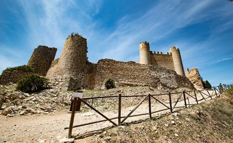
Quick facts
- Names: Castell de Xivert in Valencian, Castillo de Chivert or Castillo Templario de Xivert in Spanish; Xivert Castle or the Templar castle of Xivert in English.
- Where: municipality of Alcalà de Xivert-Alcossebre, Baix Maestrat, province of Castellón, inside the Serra d’Irta foothills.
- Coordinates: 40.3082, 0.2551 (castle, OpenStreetMap).
- Altitude: 370 m above sea level (Spanish Wikipedia).
- Built: as a Muslim fortress in the 10th and 11th centuries; remodelled by the Templars after they took it in 1234 (Turisme Comunitat Valenciana, Spanish Wikipedia).
- Size: the remains cover about 8,000 m² on the summit and slope of the hill (Turisme Comunitat Valenciana).
- Protection: listed as a Site of Cultural Interest (Bien de Interés Cultural).
- Distance: about 5 km from Alcalà de Xivert by track (Spanish Wikipedia); 2.5 km in a straight line.
Access and parking
By car: the castle is reached from Alcalà de Xivert on the track that OpenStreetMap names Camí de la Serra, which climbs into the hills east of the town. OpenStreetMap maps a parking area and a picnic site about 200 m south of the castle, with a signpost beside them, and a short footpath up to the walls. Parts of the track are mapped as unpaved, so drive slowly; we could not confirm its condition in 2026 or whether access is restricted at any time of year.
On foot or by bike: from the town it is about 5 km uphill. Other tracks, such as the Camí de Xivert from the west, also reach the hill on OpenStreetMap. The regional tourist board notes that Alcalà is linked to many walking routes through the Serra d’Irta.
Public transport: Alcalà de Xivert has a railway station about 2.3 km from the castle in a straight line (OpenStreetMap). There is no bus to the castle that we could find, so from the station you walk or take a taxi.
What to expect
The site has three parts, all ruined but partly restored. At the top is the alcazaba, the citadel. The Templars rebuilt it in the 13th century and added the two round towers and the dressed-stone curtain wall between them that you see from the east; they also built a chapel and a cistern (Turisme Comunitat Valenciana, Spanish Wikipedia). The regional tourist board mentions Gothic chapels, towers and Kufic inscriptions. Catalan Wikipedia describes an Arabic inscription, “for the meeting with God”, on a plastered wall in the south of the site.
Around it runs the albacar, a walled enclosure where people and their animals took refuge in times of conflict. Below, on the south-facing slope, are the streets and houses of the aljama, the walled Muslim and later Morisco village. Catalan Wikipedia calls it one of the best preserved examples of a hilltop Muslim town.
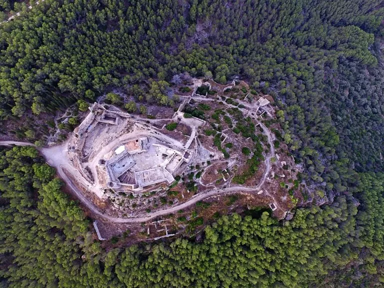
The views are the other reason to come. From the top you look over the farming plain of Alcalà and, according to the tourist board, out to the sea. Spanish Wikipedia notes that higher hills to the east hide part of the coast, so do not expect an open sea panorama in every direction. OpenStreetMap maps two viewpoints on the site.
History in brief
Excavations found a Bronze Age settlement on the hilltop, and people lived here from at least the 14th–13th centuries BC (Spanish Wikipedia). The Muslim fortress and village controlled the plain and the roads to Santa Magdalena de Polpís and Peñíscola. The Templars took Xivert in 1234 under a surrender pact that let the Muslim population keep its customs and religion. After the Order was dissolved, the castle passed to the Order of Montesa. It lost its military role in the 16th century, the village was attacked in 1521 during the Germanies revolt, and the Morisco population was expelled in 1609, after which the site was abandoned (Spanish and Catalan Wikipedia). Excavation, cleaning, better access and consolidation of the west tower, the south tower and the wall with the Arabic inscription have taken place since 1996 (Catalan Wikipedia), and the tourist board says digs are still turning up finds.
Practical details
- Opening and tickets: we could not find official opening hours or prices. The tourist board page lists none. Ask at the Tourist Info in Alcalà de Xivert before you go, especially about guided visits.
- Facilities: OpenStreetMap shows only a parking area and a picnic site. Bring water and food; we found no café or toilets on the hill.
- Time needed: allow one to two hours on site, plus the drive or walk up.
- Combine with: the old town of Alcalà de Xivert below, with its church and tall bell tower.
Accessibility and safety
This is not an accessible site. The path from the parking area is short but steep, and inside the walls the ground is uneven, with steps, loose stone and unprotected drops in places. Wear proper shoes and keep children close. The hilltop has no shade, so avoid midday in summer and carry plenty of water. Wind can be strong on the ridge.
Best time to visit
Spring and autumn are best, with mild temperatures for the climb and clear air for the views. In summer go early in the morning or late in the afternoon. Winter days can be clear and good for photographs, but windy. After heavy rain, ask locally about the state of the track.
Nearby alternatives
- Alcalà de Xivert, 2.5 km away: the old town below, with its Baroque church and bell tower.
- Santa Magdalena de Polpís, 6.7 km away: a village with the ruined castle of Polpís on a hill.
- Alcossebre, 7.5 km away: the municipality’s beach resort.
- Serra d’Irta, 9.3 km away (Torre Badum): the natural park’s coast and trails.
- Peñíscola Castle, 14.1 km away: the Templars’ other castle on this coast, home of Pope Luna.
Distances are in a straight line from the castle. For the whole stretch, see our Peñíscola and the Serra d’Irta guide.
FAQ
How do I get to Xivert Castle?
From Alcalà de Xivert take the Camí de la Serra track into the hills, about 5 km. OpenStreetMap shows a parking area about 200 m below the castle.
Is there parking at Xivert Castle?
Yes, OpenStreetMap maps a small parking area with a picnic site just south of the castle. We could not confirm its size or any fee.
Is Xivert Castle free to visit?
We found no official ticket price or opening hours. Check with the Tourist Info in Alcalà de Xivert before you go.
Who built Xivert Castle?
Muslim builders in the 10th and 11th centuries. The Knights Templar took it in 1234 and remodelled it, adding the two round towers.
Can you see the sea from Xivert Castle?
The regional tourist board says it overlooks the plain and the sea; higher hills to the east hide part of the coast.
Sources and freshness
Checked 7 November 2026 · 5 sources Show
Checked 7 November 2026. Official: Turisme Comunitat Valenciana, Castillo Templario de Xivert (dates, size, alcazaba, albacar, cistern, listing, digs) and Alcalà de Xivert-Alcossebre (routes, tourist offices). Background: Spanish Wikipedia, Castillo de Chivert (altitude, distance, history) and Catalan Wikipedia, Castell de Xivert (aljama, inscription, restoration since 1996). Location, track, parking, picnic site and viewpoints: OpenStreetMap contributors (ODbL). Photos: Wikimedia Commons, licences as credited.
This place is part of our Costa del Azahar travel guide: map, beaches, camping and the Castellón coast — see every town, beach and cove we have mapped on that coast.
How this page is made. CostaMap is written with an AI editorial system run by Ebizapple. This page is based on the sources listed above. Last updated 9 November 2026. Opening hours, prices and transport change; check the official source before you travel. How we work · Partner links and ads