
Bizkaia Bridge (Puente Colgante, Portugalete–Getxo)
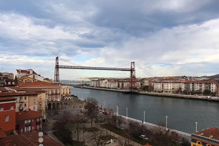
Historic siteThe Bizkaia Bridge (Puente de Bizkaia, also called the Puente Colgante or Vizcaya Bridge) is the transporter bridge over the mouth of the Bilbao estuary that links Portugalete, on the left bank, with Las Arenas in Getxo, on the right. A gondola hanging from the iron span carries cars, bikes and people across the river, and lifts in the towers take visitors up to a walkway 45 m above the water. Get there by metro or local train from Bilbao, about 9 km away in a straight line. It suits anyone interested in engineering, views and an easy half day; skip the walkway if you dislike heights.
Quick facts
- Names: Bizkaia Zubia in Basque, Puente de Bizkaia or Puente de Vizcaya in Spanish. Locals, and the bridge’s own website, usually call it the Puente Colgante, the “hanging bridge” (English Wikipedia).
- Where: at the mouth of the Ibaizabal-Nervión estuary, between Portugalete and Las Arenas (Areeta), Getxo, Bizkaia.
- Coordinates: 43.3232, -3.0172 (the middle of the span, OpenStreetMap).
- Opened: 28 July 1893, designed by Alberto de Palacio y Elissague (Basque tourism board).
- Status: UNESCO World Heritage Site since 2006, as one of the outstanding iron constructions of the European Industrial Revolution (Basque tourism board).
- First of its kind: the first transporter bridge in the world built with a metal structure (Basque tourism board).
- Size: English Wikipedia gives the span as 164 m long and the walkway at 45 m; OpenStreetMap tags the structure 45 m high.
- Still in service: yes, as a public crossing for cars, bikes and foot passengers.
Access and parking
By metro: the Basque tourism board recommends the metro and names the stop Areeta/Portugalete. Areeta station on line 1 is on the Getxo side, about 600 m from the bridge; Portugalete has its own station on line 2, higher up the town (OpenStreetMap). You can ride the gondola from one to the other.
By train: the Renfe local line C-1 from Bilbao-Abando to Santurtzi stops at Portugalete, and you walk down to the bridge (Basque tourism board; line on OpenStreetMap).
By bus: the tourism board lists Bizkaibus lines A3151 and A3135. On the Getxo side, OpenStreetMap shows a Bizkaibus stop called Bizkaia Zubia / Puente Bizkaia right by the bridge.
By car: you can drive onto the gondola, which OpenStreetMap tags as a toll crossing with a 9-tonne weight limit. For parking, OpenStreetMap maps the paid underground car park Zubi Alde on the Portugalete side, about 200 m from the bridge; on the Getxo side, the streets near the bridge have on-street parking. We found no official parking information.
By boat: a small passenger ferry, the gasolino, crosses the estuary next to the bridge for foot passengers and bikes (OpenStreetMap). The tourism board suggests taking it at least once for the best view of the bridge from the water.
What to expect
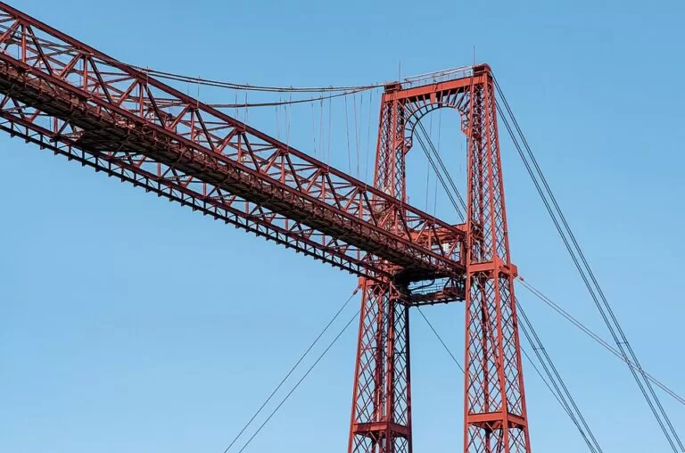
Four iron towers on the two banks hold up a high horizontal girder, and from it a gondola hangs on cables and runs across just above the water. English Wikipedia says the gondola carries six cars and several dozen passengers at a time and takes about a minute and a half to cross. The design joined the two banks without blocking ships sailing up to Bilbao.
There are two ways to visit. The first is simply to cross in the gondola, as local people do every day; the Basque tourism board calls it an exciting experience and notes you can do it in your car. The second is to take a lift up one of the towers to the top walkway, 45 m above the river. From there you look down the estuary to the open bay of the Abra and the port. The tourism board adds that you can see the gondola’s mechanisms up close: the runners, motors and suspension cables.
The bridge was the work of Alberto de Palacio, with the French engineer Ferdinand Arnodin, according to English Wikipedia. Service stopped only once, for four years during the Spanish Civil War, when the upper section was blown up; it was rebuilt and reopened afterwards.
Each bank is worth a walk. On the Portugalete side, steep medieval streets climb to the Gothic-Renaissance basilica of Santa María and the Salazar Tower (1379, says spain.info), and the Rialia Museum of Industry tells the story of the estuary. On the Getxo side, Las Arenas has a small beach by the Churruca quay, and a waterfront walk leads north towards Neguri and Algorta (Basque tourism board).
Tickets and opening
We could not open the bridge’s own website (puente-colgante.com), so we cannot give current fares or opening hours for the gondola or the walkway. English Wikipedia says the gondola runs all year, every eight minutes during the day and hourly at night, with different day and night fares, and that it accepts the Barik transport card. The Getxo tourist office can book a visit to the walkway as one of its activities (Basque tourism board). Check the bridge’s website before you go, especially for the walkway, which may close in bad weather.
Practical details
- Portugalete tourist office: Paseo de la Canilla, by the river, tel. +34 944 729 314; open daily in high season (1 July to 10 September and Easter), shorter hours the rest of the year, and closed 25 December, 1 and 6 January (Basque tourism board, checked November 2026). It runs guided visits.
- On site: OpenStreetMap shows an information board, a gift shop and drinking water by the bridge.
- Festivals: Portugalete’s San Roque fiestas run from 14 to 17 August (Basque tourism board).
Accessibility and safety
OpenStreetMap tags the bridge crossing as wheelchair accessible, with notes that the foot-passenger terminal on the east (Getxo) side is step-free. The small gasolino ferry is tagged as not wheelchair accessible. We could not confirm whether the walkway lifts and the walkway itself are accessible. The walkway is high and open to the wind; the old quarter of Portugalete is steep.
Best time to visit
The gondola runs all year, so any dry day works. Clear weather matters most for the walkway, when you can see along the estuary to the bay. Weekday mornings are quietest.
Nearby alternatives
- Getxo, 2.4 km away: the Old Port of Algorta, Ereaga beach and the cliffs of La Galea.
- Bilbao, 9.1 km away: the Guggenheim and the Old Town, at the other end of the metro line.
- Castro Urdiales, 17.4 km away: the first harbour town over the border in Cantabria.
- Bakio, 20.7 km away: the surf beach and txakoli museum at the eastern end of this coast.
- San Juan de Gaztelugatxe, 23.3 km away: the hermitage on a rock island reached by a long stairway.
Distances are in a straight line from the bridge.
FAQ
How do I get to the Bizkaia Bridge from Bilbao?
Take the metro (line 1 to Areeta, or line 2 to Portugalete) or the Renfe C-1 train to Portugalete.
Can you drive across the Bizkaia Bridge?
Yes. The gondola takes cars as well as people and bikes; English Wikipedia says it carries six cars at a time, and OpenStreetMap gives a 9-tonne limit.
Can you walk across the top of the bridge?
Yes. Lifts in the towers take visitors up to a walkway 45 m above the river, with views of the estuary and the bay. Check opening times and fares on the bridge’s website before you go.
Why is it a UNESCO World Heritage Site?
It was the first metal transporter bridge in the world, and UNESCO listed it in 2006 as one of the outstanding iron constructions of the European Industrial Revolution.
Is there parking near the bridge?
OpenStreetMap shows a paid underground car park, Zubi Alde, on the Portugalete side. Public transport is easier.
Sources and freshness
Checked 9 November 2026 · 9 sources Show
Checked 9 November 2026. Official: Basque tourism board on the Bizkaia Bridge (history, UNESCO, walkway, public transport), Portugalete and Getxo (towns, sights, festivals), Las Arenas beach, and the tourist offices of Portugalete and Getxo (address, hours, walkway visits); spain.info on Portugalete (old quarter, Salazar Tower). The bridge’s own website was not reachable, so fares and hours are not given. Background: English Wikipedia on the Vizcaya Bridge (dimensions, gondola, Civil War, service frequency). Location, stations, bus stop, car park, ferry and distances: OpenStreetMap contributors (ODbL). Photos: Wikimedia Commons, licences as credited.
How this page is made. CostaMap is written with an AI editorial system run by Ebizapple. This page is based on the sources listed above. Last updated 9 November 2026. Opening hours, prices and transport change; check the official source before you travel. How we work · Partner links and ads