
Salinas de Calp (Calpe salt flats)
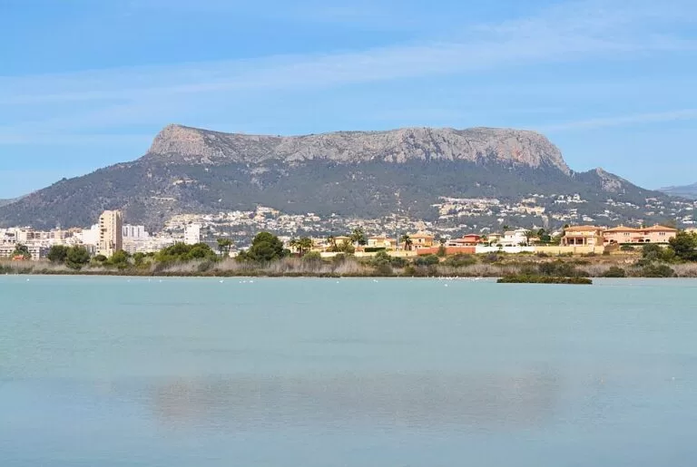
Natural parkThe Salinas de Calp (Les Salines de Calp) are a former salt lagoon in the middle of Calp, on the Costa Blanca, where flamingos feed a few hundred metres from the beaches and the Peñón de Ifach. You reach them on foot from the town centre or the Arenal-Bol and La Fossa beaches; a boardwalk viewpoint and a bird observatory stand on Avenida Bulgaria, on the west side of the lagoon, with a free car park about 350 m away. It suits birdwatchers, families and anyone staying in Calp who wants a short, flat walk; skip it if you are looking for a long hike or a wild landscape, as houses and apartment blocks surround the water.
Quick facts
- Names: Les Salines de Calp in Valencian, Las Salinas de Calpe in Spanish; in English, the Calpe salt flats or salt lake.
- Where: inside the town of Calp (Calpe), Marina Alta, Alicante, between the old town and the Peñón de Ifach.
- Coordinates: 38.6464, 0.0679 (the Pasarela Mirador Las Salinas on Avenida Bulgaria, OpenStreetMap).
- Size: 41.08 hectares, according to Spanish Wikipedia.
- Status: declared a maritime-terrestrial zone in 1993, according to Calp town council. It is not a natural park, unlike the Peñón de Ifach next door.
- Birds: flamingos all year; Spanish Wikipedia records 173 bird species here.
- Salt making: from Roman times; the last works closed in the late 1980s (1988, according to Spanish Wikipedia).
- Entry: the viewpoint, observatory and path are in public space; we found no entry charge.
Access and parking
On foot: the lagoon sits in the middle of town, between the two main beaches. Calp’s tourist office is about 600 m from the viewpoint, and the Arenal-Bol beach about the same on the other side; the Roman Baños de la Reina on the seafront are about 850 m away (OpenStreetMap, straight line).
By car: OpenStreetMap marks a free surface car park with a dirt surface about 350 m south-east of the viewpoint, on the La Fossa side. Most other car parks around the lagoon are private or belong to apartment blocks.
By bus and train: OpenStreetMap shows town bus stops on the north side of the lagoon, such as Maviro, about 600 m from the viewpoint. The regional tourist board lists Calp among the coastal towns you can reach by train from Alicante; we could not confirm where the line stops in relation to the lagoon, so check the route before you go. Alicante–Elche airport is about 68 km away in a straight line.
What to expect
The salt flats fill a hollow of young alluvial sediment behind the beaches. Calp town council explains that the lagoon formed when a double sandbar closed off part of the bay, and that the position of the Peñón de Ifach was an important factor. Spanish Wikipedia adds that the Peñón was once an island, joined to the land by these sandbars, and that a ridge of fossil dunes can still be seen between the Arenal and Cantal Roig beaches.
Salt has been made here for a long time. In Roman times production was combined with the fish farm of the Baños de la Reina on the sandbar, with its peak in the 2nd century AD. The salt pans later supplied more than 40 municipalities, declined from the late 18th century when they were blamed for fevers in the town, and were worked again in modern times by Vicente Buigues, “Ti Marguí”, until the late 1980s (Calp town council).
- Flamingos: the bird most visitors come for. Spanish Wikipedia gives a population of several hundred.
- Other birds: the town council’s birdwatching page names black-winged stilts, avocets and several gulls at the salt flats. Because Calp lies on the eastern migration route between Europe and Africa, the species change through the year.
- Viewpoints: OpenStreetMap marks the Pasarela Mirador Las Salinas, a bird observatory next to it, a wildlife information board, and a history board and second viewpoint on the south-west side.
- The path: the council describes a trail adapted for birdwatching that is easy to walk and semi-circular; the regional tourist board calls it a flat, easy walking path.
- Background: from the west side the Serra d’Oltà rises behind the town; from the summit of the Peñón de Ifach you look straight down on the lagoon.
Practical details
- Time needed: 30 minutes to an hour for the viewpoints and the path.
- Bring binoculars: the flamingos often feed in the middle of the lagoon.
- Information: Calp tourism, turismo@ajcalp.es; the council’s website has a Wikiloc map of the trail on its salt flats page.
- Combine with: the Baños de la Reina and the 19th-century Molí del Morelló mill on the seafront, and the Peñón de Ifach, whose summit path must be booked in advance.
- Opening hours: none published; the path runs through public space in town.
Accessibility and safety
The path is flat and described as easily accessible, and the main viewpoint is a boardwalk off Avenida Bulgaria. We could not confirm step-free access along the whole route, so check the council’s trail map first. There is little shade: bring a hat and water in summer. Stay on the path and do not disturb the birds or walk into the lagoon.
Best time to visit
Birds can be seen all year, according to the town council, because Calp sits on a migration route. Migration seasons bring passing species; in summer, come early in the morning or towards sunset to avoid the heat and get softer light on the water and the Peñón.
Nearby alternatives
- Port of Calpe and Real Club Náutico, 0.9 km: the fishing port and marina at the foot of the rock.
- Peñón de Ifach, 1.1 km: the 332 m rock and natural park; the summit path needs a booking.
- Cala de la Fustera, 2.7 km: a sandy cove on Benissa’s coastal path.
- Moraira, 7.3 km: Teulada’s seaside village with its castle and coves.
- Sierra de Bernia, 10.4 km: mountain walks inland between Calp and Altea.
Distances are in a straight line from the viewpoint on Avenida Bulgaria. More on the town in our Calp guide.
FAQ
Where can you see flamingos in Calpe?
In the Salinas de Calp, the lagoon in the middle of town. The boardwalk viewpoint and bird observatory on Avenida Bulgaria (38.6464, 0.0679) look straight over the water.
Is the Salinas de Calp free to visit?
Yes. The path and viewpoints are in public space and we found no entry charge.
Is there parking at the salt flats?
OpenStreetMap marks a free dirt car park about 350 m from the viewpoint on the La Fossa side. In summer it is easier to walk from your hotel or the beach.
Can you walk around the Salinas de Calp?
Partly. The town council describes an easy, semi-circular trail adapted for birdwatching rather than a full loop.
Is salt still made in Calp?
No. Modern salt production ended in the late 1980s, and the area was declared a maritime-terrestrial zone in 1993.
Sources and freshness
Checked 9 November 2026 · 8 sources Show
Checked 9 November 2026. Official: Calp town council on the salt flats (origin, history, 1993 status, trail), birdwatching (species, migration route) and the Peñón de Ifach (booking); Comunitat Valenciana tourist board on Calp (flat path, Molí del Morelló), the Arenal-Bol beach and train trips from Alicante. Background: Wikipedia (Spanish) (size, 173 species, flamingo numbers, 1988 closure, fossil dunes). Viewpoints, boards, car park, bus stops and distances: OpenStreetMap contributors (ODbL). Photo: Wikimedia Commons, as credited. Not confirmed: step-free access along the whole path, trail length, current flamingo counts.
This place is part of our Costa Blanca, Spain: towns, beaches and where to stay — see every town, beach and cove we have mapped on that coast.
How this page is made. CostaMap is written with an AI editorial system run by Ebizapple. This page is based on the sources listed above. Last updated 9 November 2026. Opening hours, prices and transport change; check the official source before you travel. How we work · Partner links and ads