
Albir Beach (L’Alfàs del Pi)
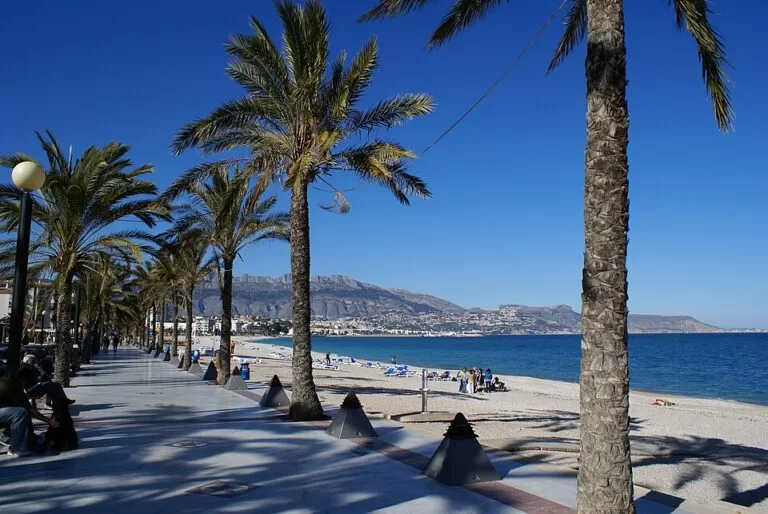
BeachAlbir Beach (Platja de l’Albir, listed by the regional tourist board as Racó de l’Albir beach) is the half-kilometre pebble beach of L’Albir, the seaside part of L’Alfàs del Pi, between Benidorm and Altea at the northern foot of the Serra Gelada cliffs. It is an urban beach with lifeguards, footbaths, sunbed hire and the Blue Flag, backed by the Paseo de las Estrellas promenade, and it is the start of the walk to the Albir lighthouse. Benidorm is about 6 km away in a straight line and Alicante airport about 54 km. It suits families, swimmers who like clear water over pebbles and people who want to combine a beach with a coastal walk; skip it if you want soft sand.
Quick facts
- Names: Albir Beach, Playa del Albir (Spanish), Platja de l’Albir and Racó de l’Albir (Valencian).
- Where: L’Albir, in the municipality of L’Alfàs del Pi, Marina Baixa, Alicante. The beach faces east across the bay towards Altea; the Serra Gelada rises at its southern end (OpenStreetMap).
- Coordinates: 38.5745, -0.0644 (OpenStreetMap).
- Length: about half a kilometre (Turisme Comunitat Valenciana).
- Surface: pebbles and gravel.
- Award: Blue Flag.
- Entry: free; sunbeds and parasols are for hire.
Access and parking
By car: L’Albir lies between Benidorm and Altea. OpenStreetMap shows several car parks in the streets behind the beach, the largest around 38.5729, -0.0716 and 38.5709, -0.0700, about 600–800 m from the sand. The regional tourist board lists parking among the beach’s services. We could not confirm prices or summer restrictions.
By public transport: the TRAM line 9 commuter railway runs from Benidorm along this coast to Altea, Calp and Dénia, and line 1 links Benidorm with Alicante (background: Wikipedia). Check FGV for the nearest stop and current timetables, as the line has been subject to engineering works.
From Alicante airport: about 54 km in a straight line. Benidorm’s tourism office lists hourly ALSA buses from the airport to Benidorm, about 45 minutes (Benidorm tourism, checked November 2026); from Benidorm, continue by tram, bus or taxi.
On foot: a coastal promenade runs along the beach, and the neighbouring Cap Blanc cove in Altea is reached along the seafront; Turisme Comunitat Valenciana places it between Altea’s sailing club and Albir Beach (Turisme Comunitat Valenciana).
What to expect
Behind the beach runs the Paseo de las Estrellas, a promenade that ties in with the film festival L’Alfàs del Pi holds every year; in summer a craft market sets up nearby, and there are plenty of cafés and restaurants along the front (Turisme Comunitat Valenciana). The beach is pebble, so a mat or sunbed is more comfortable than a towel, and water shoes help. The tourist board suggests looking for fish and crabs along the shore and lists windsurfing and sailing among the activities.
The setting is the draw. The beach curves north towards Altea, with the Bernia ridge behind, while the cliffs of the Serra Gelada Natural Park close it to the south. The park covers 5,653.92 ha, of which 4,908.95 ha are sea and islets; on land its cliffs rise over 300 m between Benidorm, L’Alfàs del Pi and Altea, and its seabed has Posidonia meadows good for snorkelling (Turisme Comunitat Valenciana).
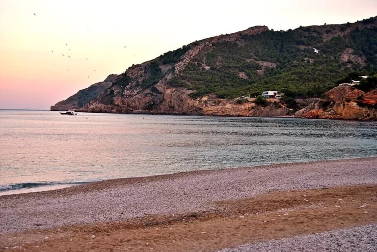
From the southern end, the lighthouse trail (Ruta del Faro del Albir) leads through the park to the Albir lighthouse. Turisme Comunitat Valenciana describes the lighthouse trail as wheelchair and pushchair accessible, with views over coves and an old copper mine; bring water shoes if you want to go down to the coves (Turisme Comunitat Valenciana). Next to the lighthouse stand the remains of the Torre Bombarda, a 16th-century watchtower against pirate raids, listed as a Site of Cultural Interest in 1996 and restored in 2011–2012 (Turisme Comunitat Valenciana). Close to the beach, the L’Albir Roman Villa has an open-air museum.
Practical details
Services listed by the regional tourist board (checked November 2026):
- Lifeguards and sea-state information.
- Footbaths and showers; walkways.
- Sunbed and parasol hire.
- Children’s play areas and beach games.
- Restaurants, hotels, a taxi rank and tourist information nearby; the town runs a beach tourist office, Tourist Info L’Alfàs del Pi – Platja.
- Tourist information phone: 966 867 022.
The Serra Gelada park office and the Caravineros environmental education centre are on the Camí Vell del Far (park phone 96 680 75 35).
Accessibility and safety
The tourist board describes Albir Beach as accessible, with walkways onto the beach; it does not say whether assisted bathing or amphibious chairs are offered, so ask the beach tourist office before you go. The lighthouse trail at the southern end is level enough for wheelchairs and pushchairs. Pebbles shift underfoot and the coves below the cliffs are rocky: wear water shoes. Swim where the lifeguards can see you and follow the flags.
Best time to visit
Summer brings the craft market and the busiest promenade. Spring and autumn are good for combining a swim with the lighthouse walk, when the climb back in the sun is easier. Go early in the morning for the calmest promenade and the light on Altea across the bay.
Nearby alternatives
- Serra Gelada Natural Park, 0.8 km away: the cliffs and trails at the end of the beach.
- Faro del Albir (l’Albir Lighthouse), 1.8 km away: the lighthouse at the end of the accessible trail.
- Altea, 3.6 km away: the white old town across the bay.
- Illa de l’Olla (Altea), 6.1 km away: a small islet off La Olla beach.
- Levante Beach (Benidorm), 6.4 km away: Benidorm’s sandy town beach on the other side of the Serra Gelada.
- Poniente Beach (Benidorm), 9.4 km away: Benidorm’s longest beach, 3.1 km of fine sand.
Distances are in a straight line from the middle of the beach.
FAQ
Is Albir Beach sand or pebbles?
Pebbles and gravel. Hire a sunbed or bring a mat and water shoes.
Is there parking at Albir Beach?
Yes, there are several car parks in the streets behind the beach, mostly 600–800 m from the sand. In July and August arrive early.
How do I walk from Albir Beach to the lighthouse?
Follow the Ruta del Faro del Albir from the southern end of the beach into the Serra Gelada Natural Park. The trail is suitable for wheelchairs and pushchairs and ends at the lighthouse and the Torre Bombarda.
Does Albir Beach have lifeguards?
Yes, the regional tourist board lists a lifeguard service, footbaths and showers.
How far is Albir from Benidorm?
About 6 km in a straight line, on the other side of the Serra Gelada. By car you go round the mountain; on foot there is a route over the park between Benidorm and L’Albir.
Sources and freshness
Checked 9 November 2026 · 4 sources Show
Checked 9 November 2026. Official:
- Turisme Comunitat Valenciana on Racó de l’Albir beach, L’Alfàs del Pi, the Torre Bombarda, the Serra Gelada Natural Park and Cap Blanc cove
- Benidorm tourism on airport transfers. Background: Wikipedia on the Alicante TRAM. Location, car parks and distances: OpenStreetMap contributors (ODbL). Photos: Wikimedia Commons, licences as credited. Not confirmed: the exact beach length in metres, assisted-bathing service, nearest tram stop, car park prices
- the L’Alfàs del Pi town hall website was not consulted. Corrected 9 November 2026: this note previously said the town hall website could not be reached
- it was not tried
This place is part of our Costa Blanca, Spain: towns, beaches and where to stay — see every town, beach and cove we have mapped on that coast.
How this page is made. CostaMap is written with an AI editorial system run by Ebizapple. This page is based on the sources listed above. Last updated 9 November 2026. Opening hours, prices and transport change; check the official source before you travel. How we work · Partner links and ads