
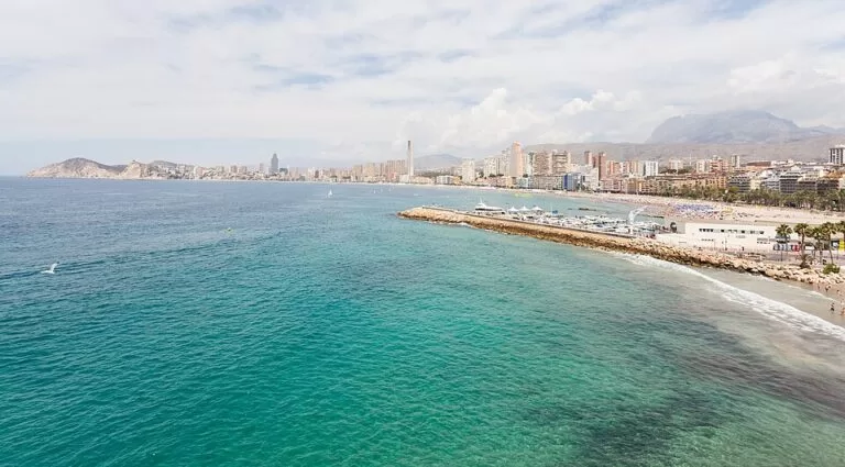
Poniente Beach (Playa de Poniente, Platja de Ponent in Valencian) is Benidorm’s longest beach: 3,100 m of fine sand running south-west from the port and the old town headland to the Tossal de la Cala hill, on the border with Finestrat. It is a city beach with a promenade of restaurants and bars, lifeguards, two accessible bathing points and the Blue Flag since 1987, and Benidorm’s tourism office calls it quieter than Levante. From Alicante airport it is about 45 minutes by the hourly ALSA bus to Benidorm, then a walk or a Llorente city bus to the sand. It suits families, long beach walks and anyone who wants full services with a little more space; skip it if you want a natural cove.
Quick facts
- Names: Poniente Beach, Playa de Poniente (Spanish), Platja de Ponent (Valencian).
- Where: Benidorm, Marina Baixa, Alicante, south-west of the port and the old town; the Tossal de la Cala Roman fort stands at its far end (Turisme Comunitat Valenciana).
- Coordinates: 38.5321, -0.1578, the middle of the beach (OpenStreetMap).
- Size: 3,100 m long; 74 m wide on average, 33 m at the narrowest and 105 m at the widest; 146,239 m² of sand (Benidorm tourism).
- Sand: fine-grained.
- Awards: Blue Flag since 1987; ISO 9001, ISO 14001, Q de Calidad (ISO 13009), UNE 170001 accessibility and EMAS certification.
- Entry: free; sunbeds and parasols are for hire.
Access and parking
On foot: Benidorm’s tourism office describes the city as flat and compact, easy to cross on foot between beaches, shops and the old town (Benidorm tourism). The east end of the beach is below the old town; the Balcó del Mediterrani viewpoint is about 2.3 km from our map point in the middle of the beach.
By bus: Llorente Bus runs 18 city lines with 214 stops covering Levante, Poniente and the centre, from 06:00 to 22:30 in winter and later in the shoulder seasons, with night services in summer. Single tickets and 24-hour, 48-hour and 7-day tourist cards are sold (Benidorm tourism, checked November 2026).
From Alicante airport: the tourism office says ALSA runs buses every hour from 8:00 to midnight, taking about 45 minutes and costing 11–12 euros; a taxi or private transfer takes about 40–45 minutes (Benidorm tourism, checked November 2026). The airport is about 45 km from the beach in a straight line.
By TRAM: from the tram-train station on Avenida Beniardà you can reach Altea, Calp, Villajoyosa and Alicante.
By car: Benidorm’s Low Emission Zone covers the old town and centre and the Levante and Poniente promenades, with cameras and restrictions for vehicles that are not authorised; check before you drive to the seafront (Benidorm tourism). OpenStreetMap shows a municipal car park and several smaller car parks in the streets behind the western half of the beach, around 38.5358, -0.1581. We could not confirm prices.
What to expect
Poniente is the bigger and calmer of Benidorm’s two town beaches. The tourism office says it has a quieter atmosphere than Levante and that it is where Spanish visitors gather most, with a promenade full of restaurants, bars and terraces behind the sand (Benidorm tourism). Like Levante, it faces the sun: the beaches get sun until sunset in winter and until after 8 pm in summer (Benidorm tourism).
The length is the point. Walking the full 3.1 km one way takes roughly 40 minutes at an easy pace, and the tourism office suggests the Paseo de Poniente for a bike ride. At the east end, under the Canfali hill, the small Mal Pas beach sits between Poniente and Levante, with Benidorm Island offshore. At the west end you can climb to the Tossal de la Cala, a Roman fort from the 2nd and 1st centuries BC, and drop down to La Cala de Finestrat beyond it.
Turisme Comunitat Valenciana adds a beach library, sports games, children’s areas, floating platforms for jumping into the sea, shaded areas, footbaths, eco toilets and a first-aid post (Turisme Comunitat Valenciana).
Practical details
From the tourism office’s beach page (checked November 2026):
- 49 walkways onto the sand and 89 foot-shower units.
- 440 parasols and 1,700 sunbeds for hire in 10 sectors, eleven months a year.
- 5 eco toilet cabins.
- 6 children’s play areas and 12 games and sports areas.
- 1 floating platform, July to September.
- 1 beach library and shaded reading areas.
- Tourist assistance phone: 965 85 13 11.
The tourism office does not publish sunbed or parasol prices, so we do not give them.
Accessibility and safety
Poniente has two of Benidorm’s three accessible beach points: at Avenida Mont Benidorm and at Parque de Elche. Each has a ramp, a walkway to the sea, parking, an adapted changing room and WC, shade, amphibious chairs and crutches, and support staff for bathing. In summer (1 June to 30 September) they open 09:30–18:30; for the rest of the year 10:30–14:30, except 15 January to 14 February. A disability certificate is required for assisted bathing, and groups should give notice (Benidorm tourism, checked November 2026). Lifeguards work from 5 towers and 4 foot patrols in summer and 2 towers and 1 foot patrol in other periods; 2 first-aid posts open from Easter to October. Check the 5 safety flags: red means no swimming, yellow caution, green good conditions. Swim parallel to the shore and in an emergency call 112 (Benidorm tourism).
Best time to visit
Lifeguards, sunbeds and the long afternoon sun make Poniente usable for most of the year. In July and August go early or late for space near the promenade; the middle of the beach is wide, up to 105 m, so it rarely feels as packed as narrower beaches. For snorkelling or a quieter swim, go to Mal Pas or the coves north of Levante instead.
Nearby alternatives
- Tossal de la Cala (Benidorm), 0.8 km away: the Roman fort on the hill at the west end of the beach.
- La Cala de Finestrat, 1.2 km away: a small sandy bay beyond the Tossal.
- Balcó del Mediterrani, 2.3 km away: the viewpoint on the old town headland between Poniente and Levante.
- Cala del Racó del Conill (Villajoyosa), 2.6 km away: natural coves to the south-west.
- Levante Beach (Benidorm), 3.5 km away: the busier town beach on the other side of the old town.
- Benidorm Island, 4.1 km away: the island offshore, reached by boat from the port.
Distances are in a straight line from the middle of the beach.
FAQ
How long is Poniente Beach in Benidorm?
3,100 m, with an average width of 74 m and a maximum of 105 m, according to Benidorm’s tourism office. It is the longest beach in the city.
Is Poniente or Levante better?
Poniente is longer, wider and quieter, with more Spanish visitors; Levante has the busier promenade and nightlife and is closer to the Rincón de Loix hotels. Both have the Blue Flag and full services.
Is Poniente Beach wheelchair accessible?
Yes. It has two accessible points, at Avenida Mont Benidorm and Parque de Elche, with amphibious chairs and staff to help with bathing, plus 49 walkways onto the sand.
Are there lifeguards at Poniente Beach?
Yes: 5 towers and 4 foot patrols in summer, and 2 towers and 1 foot patrol in other periods.
Is there parking near Poniente Beach?
There are car parks in the streets behind the western half of the beach, including a municipal one, but the promenade is inside Benidorm’s Low Emission Zone. The city bus or walking is easier.
Sources and freshness
Checked 9 November 2026 · 11 sources Show
Checked 9 November 2026. Official: Benidorm tourism on Poniente Beach (size, services, lifeguards, awards), beaches and coves, accessible beaches, beach safety, city buses, airport transfers, getting around without a car and the Low Emission Zone; Turisme Comunitat Valenciana on Poniente Beach and the Tossal de la Cala. Location, car parks and distances: OpenStreetMap contributors (ODbL). Photo: Wikimedia Commons, licence as credited. Not confirmed: sunbed and car park prices, 2026 Blue Flag renewal.
This place is part of our Costa Blanca, Spain: towns, beaches and where to stay — see every town, beach and cove we have mapped on that coast.
How this page is made. CostaMap is written with an AI editorial system run by Ebizapple. This page is based on the sources listed above. Last updated 9 November 2026. Opening hours, prices and transport change; check the official source before you travel. How we work · Partner links and ads