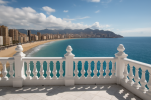
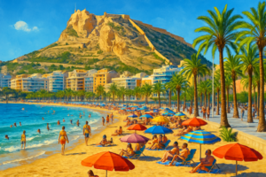
Balcó de la Mediterrània (Benidorm)
Balcó de la Mediterrània is Benidorm’s famous viewpoint with panoramic views over the Mediterranean and town beaches.
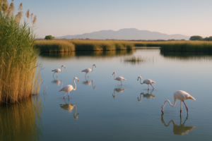
El Hondo Natural Park
El Hondo Natural Park is a key bird reserve with lagoons and reedbeds near Crevillent and Elche.
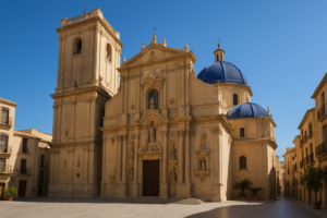
Basílica de Santa María (Elche)
Basílica de Santa María in Elche is a baroque church known for the UNESCO-recognised Misteri d’Elx play.
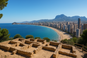
Tossal de la Cala (Benidorm)
Tossal de la Cala in Benidorm is a hilltop site with Roman ruins and panoramic views of the bay.
Playa del Postiguet (Alicante)
Playa del Postiguet is Alicante’s main beach, located below Santa Barbara Castle and near the city centre.
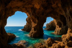
Cova Tallada (Dénia)
Cova Tallada is a large sea cave between Dénia and Jávea, accessible via a scenic coastal hike.
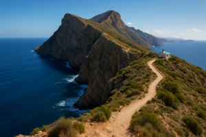
Cap de la Nau (Cabo de la Nao)
The Cap de la Nau is the easternmost headland of the Costa Blanca, where the cliffs of Jávea drop in pine-clad terraces to a deep blue sea — a classic lighthouse viewpoint and the closest point to the Balearics.
Why visit the Cap de la Nau
The cape marks the south-eastern tip of Jávea and the point where the Costa Blanca turns the corner toward Alicante. A lighthouse stands on the headland, and from the clifftop miradors the views run far out to sea — on clear days as far as Ibiza — and down a coastline of hidden coves.
The lighthouse
The Cap de la Nau lighthouse on the clifftop, the navigational marker for this corner of coast.
The miradors
Clifftop lookouts over the sea and, on clear days, the distant outline of Ibiza.
Hidden coves
The headland shelters small calas like Ambolo and Granadella along its flanks.
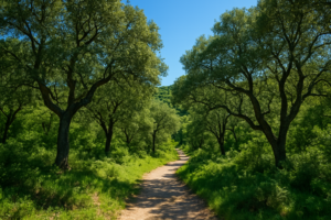
Pine terraces
Terraced pine and scrub spill down the cliffs, typical of the wild Jávea coastline.
Clifftop paths
Short trails link the miradors and lead toward the Torre del Gerro watchtower.
Sunrise point
As the easternmost cape, it is one of the first places in Spain to catch the morning sun.
On the map
The Cap de la Nau is the eastern tip of Jávea, in the Marina Alta.
Practical information
- Getting there: about 1h 30m by car from Alicante airport (ALC); a road leads up to the lighthouse car park.
- Best time to visit: early morning for the light and the clearest sea views toward the islands.
- Getting around: short level walks link the viewpoints; bring sun protection and water.
- Don’t miss: the main mirador by the lighthouse and the path toward Cala Ambolo.
Explore more of the Costa Blanca
The Cap de la Nau is one of 39 destinations on the CostaMap interactive map — browse beaches, villages, castles and viewpoints across the whole coast.
Open the map →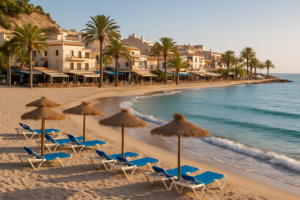
Cala de Finestrat
Cala de Finestrat is a relaxed, sandy cove beach just south of Benidorm, known for its beautiful sunsets.
Font Roja Natural Park (Alcoy)
Font Roja Natural Park offers diverse trails and one of the best-preserved holm-oak forests in Costa Blanca.
Polop de la Marina
A pretty hillside village inland from Benidorm, known for its fountain of many spouts and a hilltop viewpoint with wide views to the sea.
Torre de la Illeta (El Campello)
A tall 16th-century watchtower on the seafront at El Campello, beside the Illeta dels Banyets archaeological site, with sweeping coastal views.
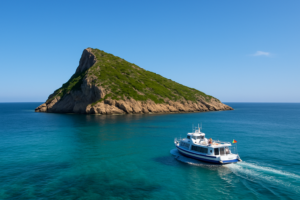
Benidorm Island (Isla de Benidorm)
A small uninhabited island off Benidorm, reached by a short boat trip, with a walking path to the summit, clear snorkelling water and a marine reserve.
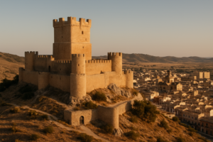
Atalaya Castle (Villena)
A dramatic medieval fortress crowning a hill above the inland town of Villena, with a great double-walled keep and sweeping views across the countryside.
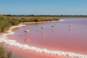
Salinas de Santa Pola
A natural park of working salt pans near Santa Pola where pink lagoons and shallow water draw flamingos and many other birds, with easy walking trails.
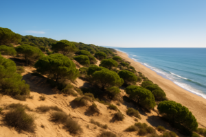
Guardamar Dunes (Guardamar del Segura)
A vast belt of pine-forested sand dunes backing the long beaches of Guardamar del Segura — a century-old reforestation project turned coastal nature walk.
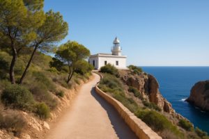
Faro del Albir (l’Albir Lighthouse)
An easy, scenic coastal walk through the Serra Gelada park to a clifftop lighthouse, with sweeping views over the bay between Albir and Altea.
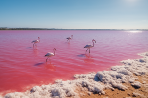
Pink Lake of Torrevieja (Laguna Rosa)
The Laguna Rosa near Torrevieja is a salt lagoon whose water turns vivid pink, part of a natural park that draws flamingos.
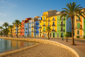
Villajoyosa (La Vila Joiosa)
Villajoyosa is a seaside town famous for its rows of brightly painted houses, sandy beaches and a chocolate-making tradition.
Marina Greenwich (Altea)
Marina Greenwich is a striking modern marina at Altea, built on the Greenwich meridian — line zero of longitude — and marked by a sweeping white wave of a building that has become a local landmark.
Why visit Marina Greenwich
The marina sits exactly on the Greenwich meridian at the foot of the Sierra Helada, between Altea and Albir. Its bold white architecture, calm yachting basin and waterfront restaurants make it a relaxed stop, and a monument marks the meridian line itself.
The wave building
The marina’s curving white signature building, echoing a breaking Mediterranean wave.
The meridian
The Greenwich meridian, line zero of longitude, runs right through the marina, marked on site.
The yacht basin
A sheltered marina of moored sailing boats and motor yachts beneath the mountains.
Waterfront dining
Restaurants and bars along the quay, strong on rice dishes and fresh Mediterranean fish.
Sierra Helada backdrop
The marina sits below the cliffs of the Serra Gelada natural park, between Altea and Albir.
L’Olla cove
The nearby L’Olla coast and its little island make for an easy seaside stroll from the marina.
On the map
Marina Greenwich lies on the coast between Altea and Albir, in the Marina Baixa.
Practical information
- Getting there: about 50 minutes by car from Alicante airport (ALC); parking by the marina.
- Best time to visit: late afternoon and sunset, when the white architecture glows.
- Getting around: flat and walkable along the quay; easy to combine with Altea old town.
- Don’t miss: standing on the meridian line and a meal on the waterfront.
Explore more of the Costa Blanca
Marina Greenwich is one of 39 destinations on the CostaMap interactive map — browse beaches, villages, castles and viewpoints across the whole coast.
Open the map →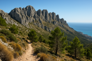
Sierra de Bernia
The Sierra de Bernia is a dramatic limestone ridge dividing the Marina Alta from the Marina Baixa, famous for a natural tunnel through the rock and a ruined Renaissance fort, with views to two coasts.
Why visit the Sierra de Bernia
The classic circular walk around Bernia is one of the best on the Costa Blanca: not too long, hugely varied, and crowned by the squeeze through El Forat, a tunnel bored clean through the ridge. The route also passes the 16th-century Fort of Bernia and opens to views over Calpe, Altea and the sea.
El Forat
A natural tunnel through the rock ridge — a short crawl that emerges to a sudden coastal panorama.
The Fort of Bernia
The ruins of a 1560s fortress built to watch the coast, set on a saddle below the main ridge.
The circular trail
A roughly 8 km loop around the massif, varied and well marked, taking around 3 to 4 hours.
The ridge top
The Bernia crest reaches 1128 m; a steep optional scramble rewards with the widest views.
Two coasts
From the south side, Calpe and the Peñón; from the north, the Marina Alta and the sea.
Pine and scrub
Aleppo pine, rosemary and thyme scent the path, with raptors often overhead.
On the map
The Sierra de Bernia rises inland between Calpe, Altea and Jávea, in the Marina Baixa.
Practical information
- Getting there: about 1 hour by car from Alicante airport (ALC) to the trailheads near Bernia.
- The walk: sturdy footwear, water and a torch for El Forat are essential; the loop is moderate.
- Best time to visit: spring and autumn for comfortable temperatures; avoid the midday summer heat.
- Don’t miss: the crawl through El Forat and lunch at the rustic restaurant near the trailhead.
Explore more of the Costa Blanca
The Sierra de Bernia is one of 39 destinations on the CostaMap interactive map — browse beaches, villages, castles and viewpoints across the whole coast.
Open the map →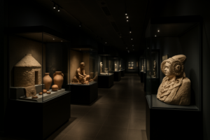
MARQ — Archaeological Museum of Alicante
The MARQ — the Archaeological Museum of Alicante — is one of Spain’s most admired museums, named European Museum of the Year in 2004 for the way it brings the region’s deep past to life.
Why visit the MARQ
Rather than rows of cases, the MARQ stages archaeology with light, sound and reconstruction, walking visitors from prehistory through the Iberians, Romans and the medieval era. Its temporary exhibitions are ambitious, and it anchors a network of real archaeological sites around the city.
Prehistory gallery
The earliest peoples of the region, with tools, cave finds and immersive reconstructions.
Iberian & Roman galleries
Iberian sculpture and Roman Lucentum finds, staged with reconstructed settings and AV.
Medieval gallery
The Islamic and Christian Middle Ages of the Alicante region, from castles to daily life.
Interactive displays
Light, sound and projection bring excavations and ancient sites vividly to life.
Temporary exhibitions
Major travelling shows — often on great ancient civilisations — fill the changing galleries.
Lucentum site
The museum connects to the Roman and Iberian site of Tossal de Manises (Lucentum) nearby.
On the map
The MARQ stands just north of Alicante’s old town, in L’Alacantí.
Practical information
- Getting there: about 15 minutes from Alicante airport (ALC); on the city tram network.
- Best time to visit: any season — an ideal rainy-day or hot-afternoon indoor visit; closed some Mondays.
- Getting around: the galleries are fully accessible and arranged in a clear chronological route.
- Don’t miss: the staged Iberian and Roman rooms and whatever temporary show is on.
Explore more of the Costa Blanca
The MARQ is one of 39 destinations on the CostaMap interactive map — browse beaches, villages, castles and viewpoints across the whole coast.
Open the map →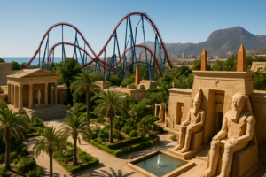
Terra Mítica (Benidorm)
Terra Mítica is the Costa Blanca’s big theme park, set in the hills above Benidorm and themed around the great ancient civilisations of the Mediterranean — Egypt, Greece, Rome and Iberia.
Why visit Terra Mítica
The park blends roller coasters and water rides with shows, parades and elaborately themed zones, making it a full family day out. Its hillside setting gives sea views from the higher rides, and it pairs naturally with a beach holiday in nearby Benidorm.
Egypt zone
Home to some of the park’s biggest coasters, including the steep drops of Titanide and Synkope.
Greece zone
The original heart of the park, with the wooden coaster and a Mediterranean village setting.
Rome zone
Gentler rides, gladiator-themed attractions and shaded spots aimed at younger visitors.
Iberia zone
An Iberian-village area with family rides, games and places to eat between the thrills.
Parades & shows
Live performances, stunt and themed shows run through the day around the park.
Water rides
Splash rides and fountains offer welcome relief on hot Costa Blanca afternoons.
On the map
Terra Mítica sits in the hills just inland of Benidorm, in the Marina Baixa.
Practical information
- Getting there: about 45 minutes by car from Alicante airport (ALC); large car parks on site.
- Best time to visit: the park is seasonal — mainly late spring to autumn; check opening dates before travelling.
- Getting around: the park is hilly; wear comfortable shoes and plan shows in advance.
- Don’t miss: the headline coasters in the Egypt zone and the evening parade in peak season.
Explore more of the Costa Blanca
Terra Mítica is one of 39 destinations on the CostaMap interactive map — browse beaches, villages, castles and viewpoints across the whole coast.
Open the map →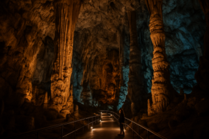
Canelobre Caves (Cuevas del Canelobre)
The Canelobre Caves above Busot are a vast, cathedral-like show cave with dramatically lit stalactites.
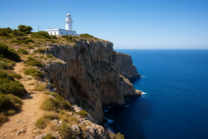
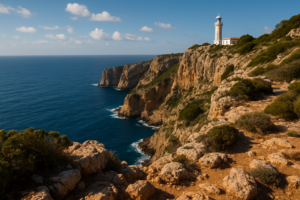
Cap de Sant Antoni (Jávea)
Cap de Sant Antoni is a clifftop cape and lighthouse between Jávea and Dénia, with sweeping views over Xàbia’s bay.
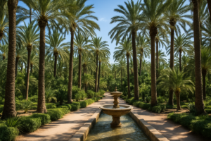
Palmeral of Elche (El Palmeral)
The Palmeral of Elche is Europe’s largest palm grove, a UNESCO World Heritage oasis of date palms in the heart of the city.
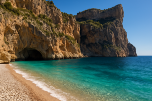
Cala del Moraig (El Poble Nou de Benitatxell)
Cala del Moraig is a dramatic pebble cove between tall cliffs near Benitatxell, with vivid turquoise water and a sea cave.
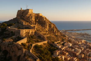
Santa Bárbara Castle (Alicante)
Santa Bárbara Castle crowns Mount Benacantil, a 166-metre rock rising straight out of the city of Alicante, with fortifications layered from Moorish times through the Middle Ages to the 18th century.
Why visit Santa Bárbara Castle
One of the largest medieval fortresses in Spain, the castle offers a 360-degree panorama over Alicante, its harbour and the sweep of the bay. Its three enclosures climb the hill in distinct historical layers, and a lift bored through the rock carries visitors up from the seafront.
La Torreta
The oldest, highest part of the castle, crowning the summit with the best views over the whole bay.
The panorama
A full sweep over Alicante’s rooftops, the marina, the Postiguet beach and the Mediterranean horizon.
The rock lift
A lift tunnelled through Benacantil rises from opposite Postiguet beach straight to the upper castle.
The Face of the Moor
The profile of a face that locals see in the cliff of Benacantil when viewed from the city below.
The three enclosures
Three walled levels from different eras tell the fortress’s long Moorish and Christian story.
Sunset over the port
Late afternoon light over the harbour and old town makes the climb especially worthwhile.
On the map
The castle rises above Alicante’s old town and Postiguet beach, in L’Alacantí.
Practical information
- Getting there: about 15 minutes from Alicante airport (ALC); reach the top by car, on foot, or by the rock lift.
- Best time to visit: late afternoon for cooler air and golden views; entry to the grounds is free.
- Getting around: wear comfortable shoes — the enclosures are connected by ramps and steps.
- Don’t miss: the keep at the very top and the lift ride back down to the beach.
Explore more of the Costa Blanca
Santa Bárbara Castle is one of 39 destinations on the CostaMap interactive map — browse beaches, villages, castles and viewpoints across the whole coast.
Open the map →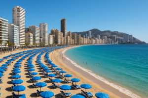
Levante Beach (Benidorm)
Levante Beach is Benidorm’s iconic crescent of golden sand beneath the city’s famous high-rise skyline.
Cala Les Rotes (Dénia)
Cala Les Rotes is a rocky snorkelling cove on Dénia’s Les Rotes coast, with clear water and natural pools among the rocks.
Serra Gelada Natural Park
The Serra Gelada is a coastal mountain ridge of sheer cliffs between Albir and Benidorm, with clifftop trails and an old lighthouse.
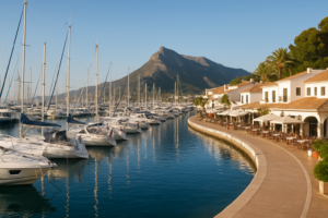
Moraira (Teulada)
Moraira is a low-key, upmarket coastal village between Calpe and Jávea, with a small marina, a seafront castle and sandy coves.
Dénia Castle
Dénia Castle crowns the town on a hill, with Islamic and medieval layers and sweeping views over the old town and sea.
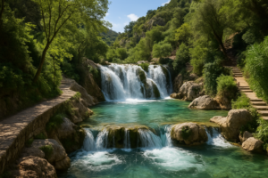
Algar Waterfalls (Les Fonts de l’Algar)
The Algar waterfalls are a chain of cascades and natural swimming pools in the hills above Callosa d’en Sarrià.
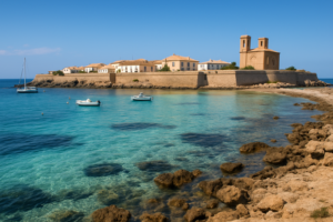
Tabarca Island
Tabarca is Spain’s smallest inhabited island, a short boat ride off Alicante, with a walled 18th-century town and clear marine-reserve waters.
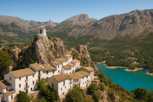
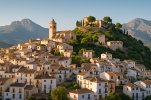
El Castell de Guadalest
El Castell de Guadalest is one of Spain’s most photographed villages: a cluster of white houses and a castle perched on a crag above a turquoise reservoir, reached through a tunnel cut into the living rock.
Why visit Guadalest
The old village sits on a rocky outcrop in the mountains behind Benidorm, its castle and white bell-tower commanding the valley. Below, the bright green-blue waters of the Guadalest reservoir fill the gorge, and the village’s many small museums add to the appeal.
Castell de Sant Josep
The ruined hilltop castle, reached on foot, with giddy views over the reservoir and the Aitana range.
The bell-tower
The white Penya bell-tower perched on its own rock spur — the village’s signature silhouette.
The reservoir
The vivid turquoise Guadalest reservoir filling the valley below, best seen from the village miradors.
The rock tunnel
The only entrance to the old village is a passage hewn through the rock beside the Casa Orduna.
The museums
A surprising cluster of small museums — micro-miniatures, salt and pepper, antique vehicles and more.
The valley miradors
Lookouts over orchards and mountains in every direction, with the sea visible on clear days.
On the map
Guadalest sits inland in the mountains of the Marina Baixa, about 25 km from Benidorm.
Practical information
- Getting there: about 1h 10m by car from Alicante airport (ALC); a large car park sits below the village.
- Best time to visit: spring and autumn, and weekday mornings to beat the tour coaches.
- Getting around: the old village is car-free and steep — comfortable shoes are useful.
- Don’t miss: the classic photo of the bell-tower from the cemetery terrace.
Explore more of the Costa Blanca
Guadalest is one of 39 destinations on the CostaMap interactive map — browse beaches, villages, castles and viewpoints across the whole coast.
Open the map →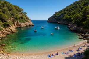
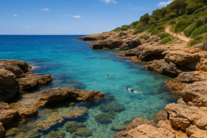
Cala Granadella (Jávea)
Cala Granadella is the jewel of Jávea’s coast: a small pebble cove of impossibly clear turquoise water, hemmed in by steep pine-clad cliffs and regularly voted one of the best beaches in Spain.
Why visit Cala Granadella
The cove is a protected stretch of the Jávea coastline, loved for snorkelling and diving in its crystal water and for the dramatic cliffs and walking trails around it. It is small and can fill quickly — part of its charm, and a reason to arrive early.
The cove
A sheltered pebble beach in vivid turquoise water, framed by pines — calm, clear and ideal for swimming.
Snorkelling & diving
Some of the clearest water on the Costa Blanca, with rocky reefs and a small dive centre on the beach.
Mirador de la Granadella
A cliff-top lookout above the cove with sweeping views down the coast — a short drive up the hill.
Coastal paths
Trails lead from the cove along the cliffs towards Cala Ambolo and the Cap de la Nau headland.
The beach restaurant
A long-standing chiringuito serving fresh fish and rice dishes right above the pebbles.
The pine forest
The Granadella forest behind the cove, replanted after wildfire, with shaded picnic spots and viewpoints.
On the map
Cala Granadella lies south of Jávea town, near the Cap de la Nau in the Marina Alta.
Practical information
- Getting there: about 1h 25m by car from Alicante airport (ALC); a narrow road descends to a small car park.
- Best time to visit: June and September, and early mornings in summer before the car park fills.
- Getting around: parking is very limited — arrive early or use the seasonal shuttle from Jávea.
- Don’t miss: snorkelling along the right-hand rocks and the view from the mirador above.
Explore more of the Costa Blanca
Cala Granadella is one of 39 destinations on the CostaMap interactive map — browse beaches, villages, castles and viewpoints across the whole coast.
Open the map →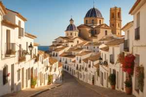
Altea
Altea is the white town of the Costa Blanca: a tangle of cobbled lanes climbing to a blue-tiled church dome high above the sea, long a magnet for painters, potters and musicians.
Why visit Altea
The old town (Altea la Vella) is among the prettiest hill villages on the coast, its lime-washed houses framing sudden views of the Mediterranean. Below, a pebble seafront and a relaxed promenade run for kilometres, while the surrounding hills hide artists studios and miradors.
The whitewashed casco antiguo
Steep cobbled streets of white houses, bougainvillea and craft shops, climbing to the church square.
The blue-domed church
Nuestra Señora del Consuelo, its blue-and-white tiled domes the symbol of Altea and the whole coast.
Plaça de l’Església
The lookout terrace beside the church, with one of the finest sea views in town — best at sunset.
The artists’ quarter
Galleries, ceramics workshops and small bars tucked into the lanes have given Altea its bohemian name.
The promenade
A long pebble beach and palm-lined Passeig with seafood terraces stretching towards Albir.
Marina Greenwich
A quirky marina just south, sitting almost exactly on the zero meridian, with restaurants and dive trips.
On the map
Altea sits on the bay between Calpe and Benidorm, in the Marina Baixa.
Practical information
- Getting there: about 50 minutes by car from Alicante airport (ALC) via the AP-7 and N-332.
- Best time to visit: late spring and early autumn for warm evenings and quieter streets.
- Getting around: park below and explore the old town on foot — the lanes are steep and pedestrian.
- Don’t miss: sunset from the church square and a drink in the artists’ quarter afterwards.
Explore more of the Costa Blanca
Altea is one of 39 destinations on the CostaMap interactive map — browse beaches, villages, castles and viewpoints across the whole coast.
Open the map →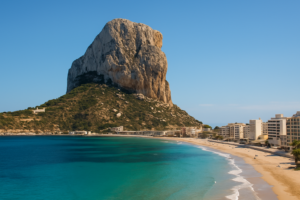
Peñón de Ifach (Calpe)
The Peñón de Ifach is the symbol of the Costa Blanca: a 332-metre limestone monolith rising almost sheer from the Mediterranean at Calpe, linked to the shore by a narrow isthmus. It is one of Spain’s smallest natural parks — and one of its most dramatic, with a marked trail right to the summit.
Why visit the Peñón de Ifach
The rock dominates Calpe and the whole northern Costa Blanca skyline. A protected natural park since 1987, it shelters seabirds, rare plants and a marine reserve in the waters around its base. The reward for visitors is the climb: a steep trail and a hand-cut tunnel lead to a summit with one of the finest panoramas on the entire coast.
Trail to the summit
About 2.5 km round trip — easy at first, then steep and rocky. Good footwear is essential; allow 2–3 hours and bring water.
The tunnel
A short tunnel cut through the rock in 1918 links the gentler lower slopes to the wilder summit path — the turning point of the walk.
The summit panorama
From the top, views stretch over Calpe, the salt flats, Altea bay and, on clear days, all the way to Ibiza.
Calpe old town
Beneath the rock, a maze of painted streets, the old fishermen’s quarter and a lively seafront with fresh-fish restaurants.
Salinas de Calpe
The town’s salt lagoon, where flamingos feed in the shadow of the Peñón — a striking sight right beside the marina.
Playa del Arenal-Bol
Calpe’s long sandy main beach, curving away from the foot of the rock with a full promenade of bars and cafés.
On the map
The Peñón rises from the sea at Calpe, in the Marina Alta on the northern Costa Blanca.
Practical information
- Getting there: about 1 hour by car from Alicante airport (ALC) via the AP-7; the park entrance and visitor centre sit at the base by Calpe marina.
- The climb: sturdy shoes, water and sun protection are essential; the upper section is steep and exposed and not suited to small children or anyone with vertigo.
- Access limits: visitor numbers on the summit trail can be capped in peak season — arrive early or check the park’s daily access rules.
- Best time to visit: spring and autumn for cooler walking and clearer air; avoid the midday heat in summer.
Explore more of the Costa Blanca
The Peñón de Ifach is one of 39 destinations on the CostaMap interactive map — browse beaches, villages, castles and viewpoints across the whole coast.
Open the map →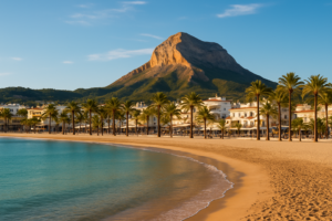
Jávea (Xàbia)
Jávea — Xàbia in Valencian — is one of the most beautiful corners of the northern Costa Blanca: a whitewashed old town set back from the sea, a working fishing port, the long sandy Arenal beach and the dramatic coves and cliffs beneath the Montgó massif.
Why visit Jávea
Jávea divides naturally into three: the historic old town (el Poble) inland, the Port district by the marina, and the Arenal seafront with its restaurants and palm-lined promenade. Between them lie some of the Costa Blanca’s finest coves and viewpoints, all within a few minutes’ drive.
El Poble
Narrow streets of pale Tosca stone, the fortified Sant Bartomeu church and a lively market — the historic heart, set back from the coast.
Platja de l’Arenal
Jávea’s main sandy beach, gently shelving and family-friendly, backed by a promenade of bars and seafood restaurants.
Cala Granadella
A pebble cove of turquoise water framed by pine-clad cliffs — regularly named among Spain’s best beaches, perfect for snorkelling.
Montgó Natural Park
The 753 m massif looming over the town, with marked trails, rare flora and sweeping views over to Dénia and the sea.
Cap de la Nau & Cap de Sant Antoni
Two headlands bracketing the coast, with lighthouses, cliff-top miradors and some of the best sunrise views on the Costa Blanca.
The fishing port
Still a working harbour, with an evening fish auction, a small church and waterfront terraces for fresh local catch.
On the map
Jávea sits on the northern Costa Blanca, between Dénia and Moraira in the Marina Alta.
Practical information
- Getting there: about 1h 20m by car from Alicante airport (ALC) and 1h 30m from Valencia (VLC), via the AP-7 motorway.
- Best time to visit: May–June and September for warm sea and quieter beaches; July–August are busiest.
- Getting around: a car is useful to move between old town, port and the coves; local buses link the three centres in summer.
- Don’t miss: sunset from Cap de Sant Antoni and a swim at Cala Granadella early in the day before the crowds.
Explore more of the Costa Blanca
Jávea is one of 39 destinations on the CostaMap interactive map — browse beaches, villages, castles and viewpoints across the whole coast.
Open the map →