
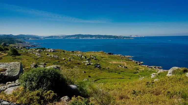
Cabo Udra is a small, low headland at the south-western tip of the Ría de Pontevedra, in the municipality of Bueu, protected as a Natura 2000 site for its coastal scrub, odd-shaped granite boulders, coves and birds. It is about 5 km west of Bueu town in a straight line; you drive out on the PO-1302 and leave the car at a free municipal car park, then walk the paths to the point, an old coastal gun battery, a nature classroom and a hill fort. Entry is free and there are views across to Ons Island and Sanxenxo. It suits walkers, families and photographers who want a short, quiet coastal walk; skip it if you want a serviced resort beach or need fully step-free paths.
Quick facts
- Names: Cabo Udra or Punta Udra in Galician and Spanish; the tip is O Puntal da Udra on OpenStreetMap. English speakers usually search for “Cabo Udra” or “Cape Udra”.
- Where: parish of Beluso, municipality of Bueu, on the north coast of the Morrazo peninsula, at the southern side of the mouth of the Ría de Pontevedra.
- Coordinates: 42.3406, -8.8364 (O Puntal da Udra, OpenStreetMap).
- Height: no point higher than 86 m (Rías Baixas tourist board).
- Protected area: 623.36 ha, of which 443 ha are sea; part of the Natura 2000 network as a Site of Community Importance (LIC), and a Galician zone for the protection of natural values (ZEPVN) (Rías Baixas tourist board).
- Managed by: Concello de Bueu.
- Entry: free, open access.
Access and parking
By car: from Bueu follow the PO-1302 west towards Beluso and Cabo Udra. The provincial tourist board lists the Cabo Udra caravan area, a municipal car park on the PO-1302 with a section for motorhomes, 4.8 km from the centre of Bueu. Parking is free, with drinking water, picnic tables and barbecues, and motorhome services; it is not an overnight area. OpenStreetMap also marks a free surface car park on the headland.
By bus: we could not confirm a bus to the cape. The tourist board names Cangas bus station (about 12 km) and Pontevedra bus station (about 27 km) as the nearest; buses run along the Morrazo between Bueu, Cangas and Marín, but check routes and stops locally.
On foot: signed paths cross the headland; the tourist board describes the signage as adequate.
What to expect
The provincial tourist board describes Cabo Udra as a small peninsula where a shoreline of little beaches alternates with coastal scrub, out of which rise groups of rocks of great scientific and landscape value. Its plants and wildlife earned it a place in the Natura 2000 network. On the ground you find:
- The point and its islets: OpenStreetMap names dozens of rocks and islets off the tip, from O Con das Pozas to O Chumizo, and marks two viewpoints on the headland.
- The J-2 coastal battery: part of a defensive system built to guard the coast during the Spanish Civil War and after the Second World War. Part of the service area was restored as a café and the nature classroom; you can still see the abandoned gun pits, a powder store, the rangefinder post, a guard hut and the water tank. Free entry; the tourist board says it needs restoration.
- The nature classroom (Aula da Natureza): a municipal centre whose exhibits and activities cover the natural and cultural, marine and land resources of the cape, which received a Blue Flag award for its environmental education. It runs on clean energy, with a wind turbine and solar panels. Information in Galician, Spanish, Portuguese and German; free.
- Castro de Udra: the remains of a castro (hill fort), free to visit, which the tourist board lists as altered by time and neglect and in need of restoration.
- Coves: OpenStreetMap marks the small beaches of Ancoradouro, Pedrón and Bucieira on the headland; Pedrón and part of Ancoradouro are tagged as naturist.
The tourist board lists a bird observatory, a picnic area and a restaurant or café among the facilities.
Practical details
- Time needed: allow one to two hours to walk the headland and see the battery and the castro.
- Bring: water, sun protection and a windproof layer; the headland is open to the sea.
- Food: the café in the old battery buildings is listed by the tourist board; we could not confirm its opening days. Bueu, 5 km east, has the fishing port and restaurants.
- Nature classroom: phone 986 390 029 (Concello de Bueu, as listed by the tourist board) to check opening times and group visits.
- Rules: it is a protected area: keep to the paths, take litter home and do not trample the coastal vegetation.
Accessibility and safety
The tourist board lists adapted public toilets and access for private vehicles and on foot. Paths on the headland are earth and rock, so we could not confirm a step-free route to the point. Stay back from wet rocks at the water’s edge, where waves can surprise you, and watch children near the gun pits of the old battery.
Best time to visit
Late afternoon and evening for the light over Ons, and spring or autumn for a cooler walk. The tourist board notes that nearby Lapamán beach has one of the best sunsets in the area, with the Ons archipelago as backdrop.
Nearby alternatives
- Sanxenxo and Praia de Silgar, 6.9 km across the ría: the busy beach town on the north shore.
- Ons Island, 8.8 km: the inhabited national park island; boats leave from Bueu among other ports, with a free Xunta authorisation needed in high season.
- A Lanzada Beach, 12.4 km: the long Atlantic beach on the O Grove isthmus.
- Cíes Islands, 14.3 km: the car-free national park islands off Vigo.
- Combarro, 14.8 km: the hórreo village on the north shore.
On the same coast, Praia de Beluso (3.1 km) is a sheltered 250 m port beach, and Praia de Lapamán (6.9 km) is a 400 m beach of fine white sand with lifeguards (Rías Baixas tourist board). Distances are in a straight line from the point.
FAQ
How do I get to Cabo Udra?
Drive west from Bueu on the PO-1302 to the free municipal car park, 4.8 km from the town centre, then walk the signed paths. We could not confirm a bus to the cape.
Is there parking at Cabo Udra?
Yes. The municipal car park on the PO-1302 is free and has a motorhome section with services, but overnight stays are not allowed.
Can you swim at Cabo Udra?
There are small coves such as Ancoradouro and Pedrón, some used by naturists. We found no lifeguard listing for them; for a supervised beach go to Lapamán.
What is there to see at Cabo Udra?
Granite boulders and islets, coastal scrub, an old coastal gun battery from the Civil War and post-war years, a nature classroom, the remains of a hill fort and views to Ons Island.
Is Cabo Udra free?
Yes. The headland, the battery, the castro and the nature classroom are listed as free.
Sources and freshness
Checked 9 November 2026 · 8 sources Show
Checked 9 November 2026. Official: Rías Baixas tourist board (Deputación de Pontevedra) listings for Cabo Udra (description, height, area, protection, facilities), Batería de costa J-2, Aula de la naturaleza, Castro de Udra, Área de caravanas de Cabo Udra, Playa de Lapamán and Playa de Beluso. The Concello de Bueu website could not be reached from our research network. Location, islets, coves, viewpoints, car park and distances: OpenStreetMap contributors (ODbL). Photo: Wikimedia Commons, licence as credited.
How this page is made. CostaMap is written with an AI editorial system run by Ebizapple. This page is based on the sources listed above. Last updated 9 November 2026. Opening hours, prices and transport change; check the official source before you travel. How we work · Partner links and ads