
El Sardinero beach (Santander)
BeachEl Sardinero is Santander’s main beach, a sweep of golden sand on the open sea about 2.3 km from the city centre, split by the Piquío gardens into the First and Second Sardinero beaches. City buses stop right behind it at Plaza de Italia and Piquío, and there are free car parks a few minutes away. It suits families, city-break visitors and anyone who wants a long beach with full services and a promenade; skip it if you want a quiet or natural beach in July and August.
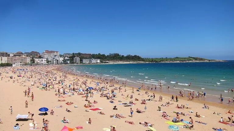
Quick facts
- Names: Playa de El Sardinero or Playas del Sardinero (Spanish): Primera Playa (Sardinero I) and Segunda Playa (Sardinero II). El Sardinero is also the name of the district behind the beach and of Racing de Santander’s football stadium.
- Where: the El Sardinero district of Santander, Cantabria, between the Magdalena peninsula to the south and the Mataleñas headland to the north.
- Coordinates: 43.4755, -3.7853 (between the two beaches, by the Piquío gardens; OpenStreetMap).
- Size: Sardinero I is 350 m long and Sardinero II 1,000 m (spain.info). At low tide the two join, and the first beach also joins La Concha, 250 m, to the south.
- Sea: spain.info rates swimming conditions as moderate waves, windy at the First beach and moderate waves at the Second.
- Name: it is named after a sardine fishing ground that once lay off the beaches (Spanish Wikipedia).
- Entry: free.
Access and parking
By bus: Santander’s city buses (Transportes Urbanos de Santander) stop all along the beach; OpenStreetMap shows stops at Piquío, Plaza de Italia and the Sardinero interchange (Intercambiador del Sardinero) by the stadium. We did not check line numbers or timetables, so look them up before you travel.
On foot or by bike: the beach is about 2.3 km from the Centro Botín in a straight line. Along the coast you can walk round the Magdalena peninsula to reach it. spain.info lists the TUeBICI bike-share, with stations in the centre, and a tourist bus that visits the main sights (spain.info, Santander).
Parking: OpenStreetMap maps a free surface car park of 172 spaces about 270 m from the beach, the free Campos de Sport car park of 674 spaces by the stadium about 500 m away, and free street parking on the surrounding streets. In summer and on match days they fill quickly.
What to expect
This is a city beach. spain.info describes the First beach as being in the heart of Santander and one of the most popular in Cantabria, easy to reach even for people with limited mobility, with a wide range of services and an attractive seafront promenade. Following the shore brings you to the Second beach and to La Concha, which it joins at low tide. Very close are the Magdalena peninsula and the lighthouse on the Isla de Mouro, and right behind the beach stands the El Sardinero stadium.
El Sardinero became fashionable from the middle of the 19th century, when sea bathing drew visitors from Castile. After the Magdalena Palace opened in 1912 as King Alfonso XIII’s summer residence, hotels, the Gran Casino and a racecourse were built in a Belle Époque style that was compared with Biarritz; the royal family spent its summers here from 1913 to 1930 (Spanish Wikipedia). The Gran Casino still stands on Plaza de Italia, and the Piquío gardens, on a small headland between the two beaches, make a natural viewpoint over both.
The Second beach, to the north, is the longer and more open of the two, with flats and a broad garden strip behind it. At its northern end the Mataleñas headland rises towards the Cabo Mayor lighthouse, which, Wikipedia says, presides over the entrance to the Bay of Santander. Mataleñas has its own small beach of 125 m, reached on foot (spain.info). In the other direction, south of La Concha, the Magdalena peninsula has calmer beaches inside the bay.
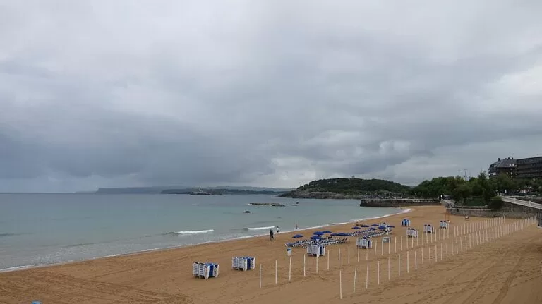
Practical details
- Facilities: spain.info lists sunshade and sun-lounger rental, toilets, showers, footwashes, bins, a cleaning service, a telephone, a sports area and a children’s play area on both beaches, and a tourist office at the First beach.
- Toilets: OpenStreetMap shows several paid public toilets along the promenade, some marked wheelchair accessible.
- Food: the promenade and Plaza de Italia have cafés and restaurants; for seafood in the city, spain.info points to the fishing quarter, the Barrio Pesquero.
- Dogs: we found no official dog rule; follow the signs on the promenade.
Accessibility and safety
spain.info says the First beach is easy to reach even for people with limited mobility, and OpenStreetMap marks some toilets and the Plaza de Italia bus stop as wheelchair accessible. We could not confirm amphibious chairs or adapted bathing from an official page. The beaches face the open sea with moderate waves and wind; swim where the flags show, and take care on the rocks at the ends of the beach at low tide.
Best time to visit
July and August are the beach season and the busiest time. June and September are quieter. Out of season the promenade is still worth a walk, from Piquío to Mataleñas, and the Magdalena peninsula is next door.
Nearby alternatives
- Santander, 2.3 km away: the city centre, the Centro Botín and the ferry port.
- Isla de Mouro, 2.4 km away: the lighthouse islet at the mouth of the bay, in view from the beach.
- Isla de Santa Marina, 4.5 km away: the island off the beaches across the bay.
- Somo beach, 4.7 km away: the long surf beach across the bay, reached by the passenger boat.
- Liencres Dunes, 14.5 km away: the dunes and wild beach of Valdearenas west of the city.
- Santillana del Mar, 27.5 km away: the medieval village near Altamira.
Distances are in a straight line from the Piquío gardens.
FAQ
How do I get to El Sardinero beach from Santander centre?
Take a city bus to Piquío or Plaza de Italia, walk about 2.5 km along the bay, or use the TUeBICI bike-share.
Is there parking at El Sardinero?
Yes. OpenStreetMap shows a free 172-space car park about 270 m from the beach, the free 674-space car park by the stadium and free street parking nearby.
What is the difference between the First and Second Sardinero beaches?
They are two beaches on the same bay, separated by the Piquío gardens. The First is 350 m and the Second 1,000 m, and they join at low tide.
Can you swim at El Sardinero?
Yes. spain.info rates the waves as moderate. Swim where the flags show.
Is El Sardinero good for families?
Yes. Both beaches have toilets, showers, sunshade rental and a children’s play area, and the First is easy to reach with limited mobility.
Sources and freshness
Checked 9 November 2026 · 8 sources Show
Checked 9 November 2026. Official: spain.info (Turespaña) beach sheets for Sardinero I, Sardinero II, La Concha and Mataleñas (size, waves, services, access), and the Santander page (getting around, fishing quarter). The Santander and Cantabria tourist sites could not be reached or blocked our requests. Background: Wikipedia, El Sardinero (name, history, casino) and Santander (Cabo Mayor). Location, bus stops, car parks and toilets: OpenStreetMap contributors (ODbL). Photos: Wikimedia Commons, licences as credited.
How this page is made. CostaMap is written with an AI editorial system run by Ebizapple. This page is based on the sources listed above. Last updated 9 November 2026. Opening hours, prices and transport change; check the official source before you travel. How we work · Partner links and ads