
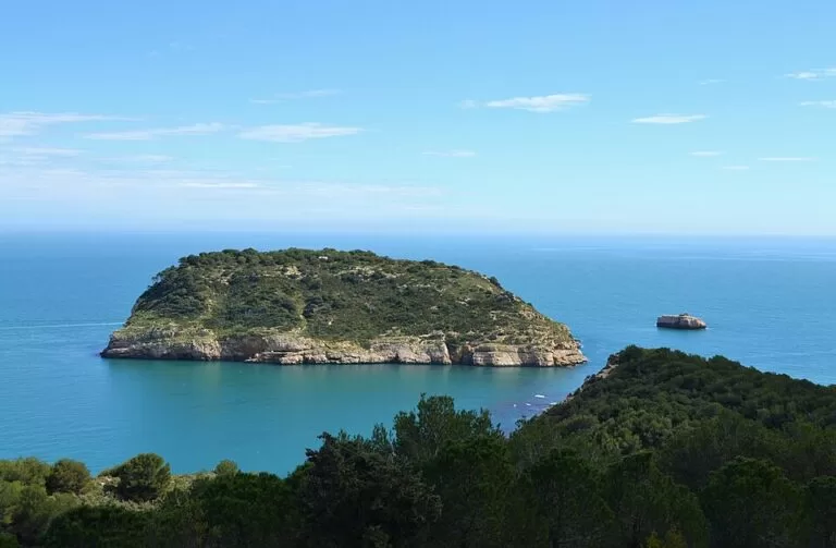
The Illa del Portitxol (Isla del Portichol in Spanish) is the round, flat-topped island in Portitxol Bay, Xàbia (Jávea), about 180 m off the coast and 250–300 m from the pebbles of Cala Barraca. You see it from the cove and from the Creu del Portitxol viewpoint; the only way out to it is by kayak, boat or swimming, and the island is private property. Xàbia’s tourist office recommends it for scuba diving, and it is a protected archaeological site with Roman remains. It suits snorkellers, divers and paddlers; skip it if you expect to walk on it or find any services.
Quick facts
- Names: Illa del Portitxol in Valencian, Isla del Portichol in Spanish. Portitxol comes from the Latin porticeolu, “little port” (Catalan Wikipedia).
- Where: Portitxol Bay, between Cap Prim and Cap Negre, Xàbia (Alicante), Marina Alta. It sits opposite Cala Barraca, also called Cala del Portitxol.
- Coordinates: 38.7552, 0.2297.
- Size: 8.3 hectares, 398 m long and 274 m wide, highest point 75 m (Spanish Wikipedia). Xàbia’s tourist office describes it as about 300 m across.
- Distance from shore: 183 m at the nearest point, over an underwater ridge about 3 m deep (Spanish Wikipedia; OpenStreetMap gives 181 m). Cala Barraca is about 250–300 m away.
- Protection: declared a Bien de Interés Cultural, as an archaeological zone, by the Valencian government in 2018.
- Ownership: private.
- Entry: no ferry, ticket or visitor service.
Access and parking
To the shore: you see the island best from two places. Cala Barraca is reached by car from the Cabo de la Nao road and the Carrer de la Barraca; the Creu del Portitxol viewpoint, about 800 m from the island, has a free car park beside it on OpenStreetMap. From the viewpoint, the signed SL CV-98 path goes down to Cala Barraca (Xàbia tourism).
Summer parking, 2026: Xàbia regulates access to Cala Barraca. In 2026, access was controlled daily from 2 June to 13 September, then at weekends and on bank holidays until 12 October. Parking cost 9 euros per vehicle per day, with 59 spaces in the Calle de la Barraca and no booking. The last stretch of road is closed by a barrier except for reduced-mobility vehicles, ambulances and authorised activity companies. No public transport serves La Barraca (Xàbia coves access, checked November 2026).
Onto the water: the tourist office lists canoeing among the cove’s activities. We could not confirm where to hire a kayak or which companies run trips round the island.
What to expect
A steep-sided island with pale limestone cliffs at the waterline and a flat top covered in scrub and pine. Spanish Wikipedia says paths made by hikers cross it and a small building stands on the highest part. Catalan Wikipedia describes the flat summit, about 1,700 m², as terraced for farming in the 20th century. The terraces had low walls, three drying floors for sun-dried raisins, an oven for scalding grapes and a small hut with a cistern.
Its history is older. It is one of Xàbia’s three Roman coastal settlements. Farm work turned up wall foundations, mortar floors, a marble-slab floor, a column base and two burials. Pottery found there runs from the Bronze Age and Phoenician period to Roman times, between the 1st century BC and the 5th century AD. The island was then abandoned and occupied again in the Islamic medieval period. Anchor stocks and amphorae on the seabed show that the bay was used as an anchorage (Catalan Wikipedia). Xàbia’s tourist office notes that the island was once inhabited and that burial sites have been found there.
The island is in private hands. Guillermo Pons Ibáñez bought it in 1957, and on his death in 1997 it passed to his nephews, who own it today (Spanish Wikipedia).
The bay itself is a flora microreserve area: in May 1999 the Valencian government protected Cap Prim and the Portitxol or Barraca beaches. Xàbia’s tourism office points to the brown algae (Cystoseira) among the boulders as a sign of excellent water quality.

Practical details
- Diving and snorkelling: both the town and the regional tourism board recommend the island for scuba diving, and the cove for snorkelling (Comunitat Valenciana).
- Landing: the island is private and a protected archaeological zone. We found no official rule on landing, so stay off it unless the owners or an authorised operator say otherwise, and never dig or remove anything.
- Nearby rock: OpenStreetMap marks a rock called l’Escull de l’Illa about 160 m south-east of the island.
- Food: OpenStreetMap lists Restaurante La Barraca and Cala Clemence by the cove, about 440 m from the island. We did not check opening hours or prices.
Accessibility and safety
The island has steep rock edges and no landing point we could confirm. Cala Barraca is all pebbles and boulders, with no step-free route to the water that we could confirm. Reduced-mobility vehicles may pass the summer barrier. If you swim or paddle out, mind boat traffic in the bay and check the Red Cross sea-conditions report linked from Xàbia’s beach pages before you go.
Best time to visit
Outside the regulated season, from mid-October to the end of May, you can drive to Cala Barraca without the 59-space limit. In summer, arrive early: the town and the regional board both describe the cove’s occupancy as high. For snorkelling and paddling, choose a calm, clear day.
Nearby alternatives
- Cala del Portitxol (Jávea), 0.6 km away: the pebble cove facing the island, with summer parking rules.
- Cap de la Nau (Cabo de la Nao), 2.5 km away: the cape viewpoint south of the bay.
- Cala Granadella (Jávea), 4.2 km away: Xàbia’s other controlled cove.
- Cap de Sant Antoni (Jávea), 6.0 km away: the northern cape and its marine reserve.
- Jávea (Xàbia), 6.7 km away: the town guide, with the old town, port and Arenal beach.
Distances are in a straight line from the island.
FAQ
Can you visit the Illa del Portitxol?
You can see it from Cala Barraca and the Creu del Portitxol viewpoint, and dive or snorkel around it. The island is private and a protected archaeological zone, so do not land without permission.
How far is the Portitxol island from the shore?
About 183 m at the nearest point and roughly 250–300 m from Cala Barraca, where most people start.
Is there parking near the Portitxol island?
Yes. In 2026 summer parking at Cala Barraca cost 9 euros a day for 59 spaces, without booking. A free car park lies by the Creu del Portitxol viewpoint, a walk away.
Can you dive at the Illa del Portitxol?
Yes. Xàbia’s tourist office and the regional tourism board both recommend it for scuba diving.
Is there a bus to Cala Barraca?
No. The town says no public transport serves La Barraca.
Sources and freshness
Checked 6 November 2026 · 8 sources Show
Checked 6 November 2026. Official: Xàbia tourism (town council) on Cala Barraca o Portitxol (island, diving, activities), Creu del Portitxol (size, burials), Portitxol Bay (microreserves, paths, algae) and coves access 2026; Turisme Comunitat Valenciana on Barraca Cove. Background: Spanish and Catalan Wikipedia (size, height, distance, history, archaeology, ownership, 2018 heritage listing). Location, parking, restaurants and distances: OpenStreetMap contributors (ODbL). Photos: Wikimedia Commons, licences as credited.
This place is part of our Costa Blanca, Spain: towns, beaches and where to stay — see every town, beach and cove we have mapped on that coast.
How this page is made. CostaMap is written with an AI editorial system run by Ebizapple. This page is based on the sources listed above. Last updated 6 November 2026. Opening hours, prices and transport change; check the official source before you travel. How we work · Partner links and ads