
Les Rotes to Torre del Gerro walk (Dénia)
Hiking trailThe Les Rotes walk to the Torre del Gerro follows Dénia’s rocky southern shore and ends at a 16th-century watchtower on the hill above, at the border with Xàbia. On OpenStreetMap it is about 2.1 km one way from the start of the cobbled Les Rotes promenade near Punta del Sard: first along the sea, then on the quiet road at the end of Les Rotes, then up a short track and path to the tower. The regional tourist board calls the walk to the tower a simple one, suitable for children. Skip it at midday in summer: the hill around the tower is open scrub with little shade.
Quick facts
- Names: Les Rotes (Valencian; Las Rotas in Spanish) is the rocky coast south-east of Dénia. Torre del Gerro is also called the Torre de l’Aigua Dolça. Dénia’s tourist office lists it as “Route 5: Les Rotes – Torre del Gerro – Cabo de San Antonio”.
- Start: the cobbled promenade near Punta del Sard, Les Rotes, Dénia. Coordinates 38.8308, 0.1481.
- End: Torre del Gerro, 38.8199, 0.1596.
- Distance: about 2.1 km one way, 4.2 km there and back (measured on OpenStreetMap; no official figure confirmed).
- Surface: cobbles and concrete with some steps on the promenade, asphalt on the road section, then a dirt track and footpath to the tower.
- Protected area: the Les Rotes shore lies in the Cabo de San Antonio Marine Nature Reserve, which includes a marine fishing reserve.
- Cost: free.
Access and parking
By car: Les Rotes is reached on the road from Dénia that becomes the Carretera Barranc del Monyo. OpenStreetMap shows a free surface car park run by the Dénia town hall, the Parking de l’Antic Mini-Golf, about halfway along Les Rotes, and two small car parks near the Hotel Les Rotes. There are bike racks along the promenade and motorbike parking at Les Arenetes.
Shorter option: according to the regional tourist board, you should reach the tower on foot, but you can drive to within 300 m of it on an asphalt road through the housing estate on the hill, to the dead end of Carrer de la Via Làctia.
By bus: OpenStreetMap maps a DeniBus line to Les Rotes, from Explanada Cervantes in Dénia to the Restaurante Mena stop at Les Arenetes, close to the end of the promenade. We could not confirm the current timetable or season.
The route
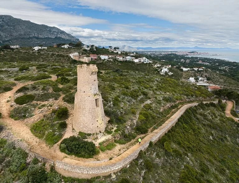
The first part is the Les Rotes promenade, a lit path paved with rough stone cobbles and concrete, with short flights of steps, running just above the rocks past Punta Negra to the small cove of Les Arenetes. From there the walk follows the end of the Les Rotes road (Carretera Barranc del Monyo) and Carrer de la Via Làctia uphill, then a dirt track and a footpath, tagged on OpenStreetMap as an easy hiking path, up to the tower. OpenStreetMap gives about 1.3 km to Les Arenetes and about 0.9 km more to the tower.
The regional tourist board describes Les Arenetes as a 300 m rocky cove at the end of Les Rotes, with a lookout towards the Cap de Sant Antoni, information panels on the flora and fauna of the cape and benches. Near the tower, OpenStreetMap marks the Mirador les Rotes, a viewpoint over the Cala d’Aigua Dolç, and the Cova de l’Aiguadolç sea cave below.
The Torre del Gerro is a 16th-century watchtower that watched the sea. Its odd jug shape, its machicolation and its crenellated top give it a distinctive silhouette on the coastline. The tourist board suggests photographing it with the sea behind.
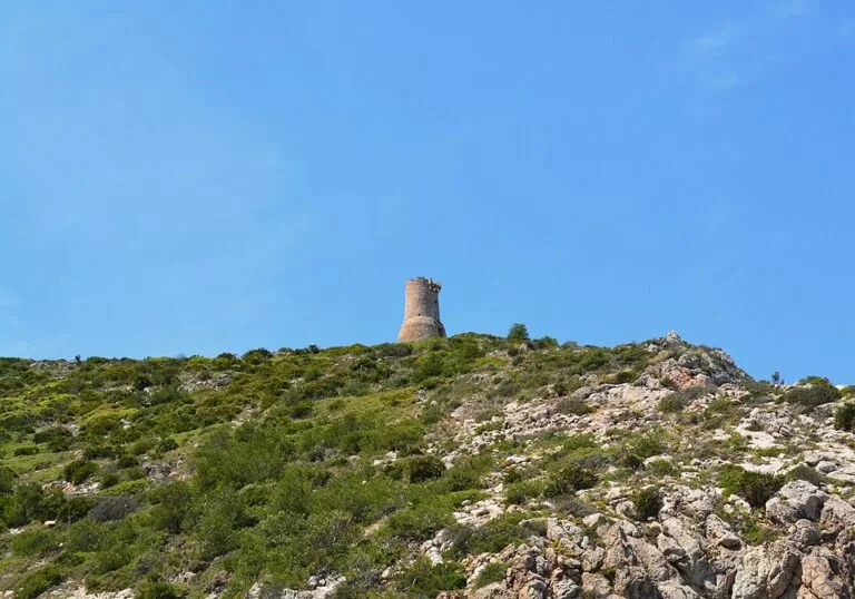
Going further: beyond the tower, paths continue south towards the Cap de Sant Antoni. OpenStreetMap shows them as narrower rocky footpaths, and one branch near the tower is tagged as demanding mountain hiking. Dénia’s own Route 5 continues to the cape; we could not open its official description, so check it with the tourist office before you go on.
Practical details
- Marine reserve rules: the Cabo de San Antonio reserve covers about 900 hectares between Dénia and Xàbia. A fishing reserve at its eastern end covers almost all the rocky coves of Les Rotes; fishing and diving there need authorisation. Swimming is allowed, and the board recommends Les Arenetes for snorkelling.
- Diving permits: apply in advance to the regional agriculture and fisheries office in Alicante (tel. 012 or 963 866 000), as listed by the tourist board.
- Lifeguards: the Red Cross covers Les Arenetes in summer.
- Food: the tourist board names two restaurants near Les Arenetes, Ca Nano and Mena.
- Water and shade: we could not confirm drinking water along the route; bring your own.
Accessibility and safety
The promenade has steps and rough cobbles, so it is not step-free. The last part to the tower is a dirt track and footpath uphill; wear proper shoes. The rocks of Les Rotes are uneven and slippery near the water. Paths beyond the tower towards the cape are narrower and rockier and need more care. In summer, start early or late: the hill around the tower is open scrub.
Best time to visit
Spring, autumn and winter mornings are the most comfortable for walking. In summer, go early, then swim or snorkel at Les Rotes afterwards, with lifeguard cover at Les Arenetes.
Nearby alternatives
- Cala Les Rotes (Dénia), 0.3 km from the tower: our guide to the rocky swimming coast along the route.
- Cova Tallada, 0.7 km away: the sea cave in the cliffs of the cape, with regulated access.
- Montgó, 3.2 km away: the mountain at the centre of the Montgó Natural Park.
- Cap de Sant Antoni, 3.7 km away: the cape and its viewpoint on the Xàbia side.
- Dénia Castle, 5.2 km away: the castle above Dénia town.
Distances are in a straight line from the Torre del Gerro.
FAQ
How long is the walk from Les Rotes to the Torre del Gerro?
About 2.1 km one way from the start of the Les Rotes promenade, or 4.2 km there and back, measured on OpenStreetMap. From the end of the Les Rotes road at Les Arenetes it is about 0.9 km.
Is there parking for the Torre del Gerro?
Yes. There is a free town-hall car park halfway along Les Rotes, and you can drive to within 300 m of the tower via the housing estate to the end of Carrer de la Via Làctia.
Is the Torre del Gerro walk suitable for children?
The regional tourist board calls the walk to the tower simple and ideal for an outing with children. Expect steps on the promenade and an uphill dirt path at the end.
Can you go inside the Torre del Gerro?
We could not confirm that the tower is open inside. The tourist board presents it as a monument to see and photograph from outside.
Can you swim at Les Rotes?
Yes. Swimming and snorkelling are allowed in the marine reserve; fishing and diving in the fishing reserve need authorisation. Les Arenetes has Red Cross lifeguards in summer.
Sources and freshness
Checked 6 November 2026 · 6 sources Show
Checked 6 November 2026. Dénia’s tourism website (denia.net) could not be opened from our tools, so the official route sheet for Route 5 was not read; we saw only its title in the site’s search results. Official: Comunitat Valenciana tourist board pages on the Torre del Gerro (history, access, 300 m approach), Les Arenetes (cove, lookout, lifeguards, restaurants, diving permits), El Trampolí, the Cabo de San Antonio marine reserve (size, rules) and Montgó Natural Park. Route line, distances, surfaces, car parks, bus line and viewpoints: OpenStreetMap contributors (ODbL). Photos: Wikimedia Commons, licences as credited.
This place is part of our Costa Blanca, Spain: towns, beaches and where to stay — see every town, beach and cove we have mapped on that coast.
How this page is made. CostaMap is written with an AI editorial system run by Ebizapple. This page is based on the sources listed above. Last updated 6 November 2026. Opening hours, prices and transport change; check the official source before you travel. How we work · Partner links and ads