
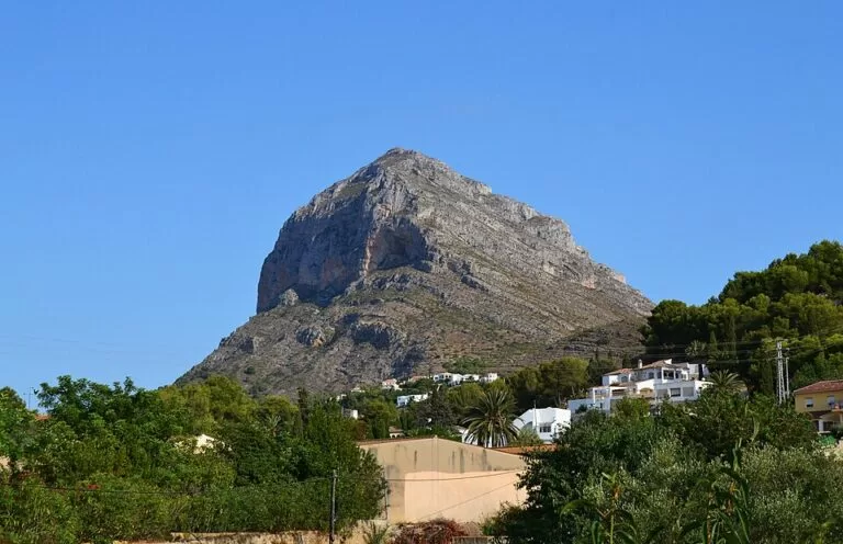
Montgó is the 753 m limestone mountain between Dénia and Xàbia (Jávea) on the northern Costa Blanca, and the heart of the Montgó Natural Park. You can hike to the summit, and the signposted PR-CV 355 climbs to it from the port of Xàbia. Gentler park routes lead to the Cova de l’Aigua cave, with its Roman inscription, and to the windmills and cliffs of the Cap de Sant Antoni. It suits fit walkers who want the big view over both bays, as well as families on the easier routes. Skip the summit in summer heat: there is no shade or water up top.
Quick facts
- Names: Montgó (Valencian: el Montgó, Massís del Montgó). The summit is called Cap Gros del Montgó on OpenStreetMap, and the cairn on top is the Creu de Xàbia. The park’s brochure traces the name to the Arabic-era “Caon”.
- Where: between Dénia and Xàbia, Marina Alta, Alicante.
- Coordinates: 38.8032, 0.1294 (the summit).
- Height: 753 m (Xàbia tourist office); 752 m on OpenStreetMap.
- Natural park: declared in March 1987 by the Valencian government. It covers 2,117.68 ha, plus a buffer zone added in 2002 that brings the protected area to about 7,504 ha. It includes the Cap de Sant Antoni and Les Planes.
- Plants: more than 650 species (park brochure; the Xàbia tourism site says over 800), including the endemic Carduncellus dianius (herba santa).
- Visitor centre: Camí Bosc de Diana, Dénia, phone +34 96 646 71 55 (Xàbia tourism).
- Entry: free.
Routes
Summit on the PR-CV 355 (Port de Xàbia–Montgó): the Xàbia tourist office lists this yellow-and-white waymarked trail as part of Xàbia’s network of natural areas. On OpenStreetMap it runs about 9 km one way from the port side of Xàbia up the east ridge to the summit. The paths near the top are tagged as mountain hiking, and some side paths as demanding. We could not confirm an official time or climb, so plan a full day. The tourist office notes that the Cala Tangó variant is closed because of the poor state of the path (Xàbia tourism, checked November 2026).
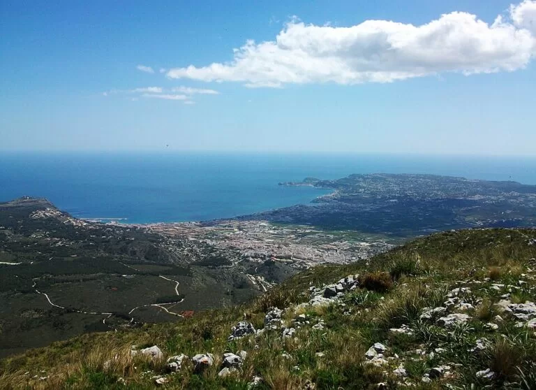
Cova de l’Aigua and Racó del Bou: rated low difficulty in the park’s brochure, at 3.5 km, a 350 m climb and about 3½ hours. It starts at the 17th-century Ermita del Pare Pere on the Dénia side and climbs through the old Montgó farming colony, where you can still see the scars of past fires. Steps lead up to the cave, which collects filtered rainwater. Behind a grille is a Roman inscription cut into the rock in AD 238. On clear days you can see the Gulf of Valencia and Ibiza.
Les Planes, the recreation area and the windmills: an easy 4.5 km loop of about 2 hours with almost no climb. It starts at the recreation area 700 m before the Cap de Sant Antoni lighthouse, which has parking under the pines, tables and drinking water. It passes the Mare de Déu dels Àngels sanctuary and the Mirador dels Molins, a group of old windmill towers. The park says the towers are unique in the Valencian Region and date from the 14th to 18th centuries.
Cap de Sant Antoni to the Cala del Tango: 2 km, about 1 hour and 160 m of descent, from the first viewpoint before the lighthouse down to the cove next to the port of Xàbia. Check the closure notice above before you take it.
What to expect
Geologically, Montgó is the last unit of the Prebetic range: a limestone syncline cut by faults on the Dénia and Xàbia sides, which explains its steep walls. Wildfires have reduced the pine woods. Much of the mountain is now low scrub of kermes oak, lentisk, rosemary and heather, with rare cliff plants on the shady north face. Birds include Bonelli’s eagle, a pair of eagle owls, kestrels and peregrine falcons. On the sea cliffs you can see Audouin’s and yellow-legged gulls and shags. People have used the mountain since the Upper Palaeolithic, and caves and Iberian sites lie around it (Wikipedia; park brochure).
Access and parking
The CV-736 between Dénia and Xàbia crosses the park. The Les Planes recreation area near the Cap de Sant Antoni has roadside parking, according to the park’s brochure. The Ermita del Pare Pere, start of the Cova de l’Aigua route, is on the Camí de la Colònia del Montgó on the Dénia side. The summit routes usually start from the Dénia or Xàbia edges of the mountain. We could not confirm official car parks or a bus at the trailheads from an official source.
Safety and rules
The upper mountain is steep, rocky and exposed, with no shade, water or shelter. Clouds often cap the summit. Wear proper boots, carry plenty of water, and do not climb in summer heat, storms or fog. Free camping is not allowed in the natural park. Wildfires have burned parts of the park before: never light a fire.
Best time to visit
October to May. Rain peaks in autumn and summer is dry and hot (park brochure). Start early so you are off the exposed upper slopes before midday.
Nearby alternatives
- Les Rotes to Torre del Gerro walk, 3.5 km: a coastal walk below the mountain to the 16th-century Torre del Gerro watchtower.
- Jávea (Xàbia), 3.5 km: the town at the southern foot of Montgó.
- Cova Tallada, 3.7 km: a sea cave in the cliffs between Les Rotes and the Cap de Sant Antoni.
- Cap de Sant Antoni, 5.8 km: the lighthouse headland at the sea end of the park.
- Mirador de la Creu del Portitxol, 9.3 km: a viewpoint over Xàbia’s southern coves.
Distances are in a straight line from the summit.
FAQ
How high is Montgó?
753 m, according to the Xàbia tourist office; the summit survey point is 751.8 m.
Which trail goes to the top of Montgó?
The waymarked PR-CV 355 runs from the port of Xàbia to the summit. Other paths come up from the Dénia side. The final stretch is steep and rocky.
Is there an easy walk on Montgó?
Yes. The Les Planes and windmills loop (4.5 km, about 2 hours, almost flat) and the Cova de l’Aigua route (3.5 km, low difficulty) suit most walkers.
Where is the Roman inscription?
In the Cova de l’Aigua, reached from the Ermita del Pare Pere on the Dénia side. It is cut into the rock behind a grille and dates from AD 238.
Can I camp on Montgó?
No. Free camping is not allowed in the natural park (park brochure); there are campsites and other accommodation around Dénia and Xàbia.
Sources and freshness
Checked 6 November 2026 · 5 sources Show
Checked 6 November 2026. Official: Xàbia tourism on Montgó Natural Park (height, 1987 declaration, birds, visitor centre, PR-CV 355, Cala Tangó closure) and the Generalitat Valenciana park brochure El Montgó hosted there (area, geology, history, three routes, camping rule); Comunitat Valenciana tourism (birding, summit hike). The park’s own site (parquesnaturales.gva.es) and denia.net could not be reached. Background: Spanish Wikipedia. Summit, PR-CV 355 line and paths: OpenStreetMap contributors (ODbL). Photos: Wikimedia Commons, licences as credited.
This place is part of our Costa Blanca, Spain: towns, beaches and where to stay — see every town, beach and cove we have mapped on that coast.
How this page is made. CostaMap is written with an AI editorial system run by Ebizapple. This page is based on the sources listed above. Last updated 6 November 2026. Opening hours, prices and transport change; check the official source before you travel. How we work · Partner links and ads