
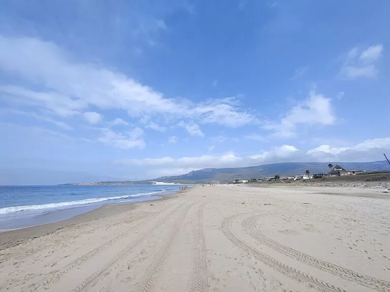
Playa de Bolonia is a long, undeveloped white-sand beach in Tarifa, on the Atlantic coast of Cádiz, about 16 km north-west of Tarifa town by straight line and reached by a single road off the N-340. At its western end a protected sand dune more than 30 m high runs up into the pines, and the Roman ruins of Baelo Claudia stand about 1 km behind the sand. It suits walkers, windsurfers and anyone who wants space and history in one place; skip it on strong east-wind days if you want a calm swim.
Quick facts
- Names: Playa de Bolonia, Bolonia beach in English. The hamlet behind it is El Lentiscal. The name is thought to come from the Roman city of Baelo.
- Where: Ensenada de Bolonia, Tarifa (Cádiz), between Punta Camarinal to the west and Punta Paloma to the east, facing Tangier across the Strait.
- Coordinates: 36.0822, -5.7640.
- Length: 3,800 m by about 70 m according to Spain’s tourism site; the Andalusian tourist board lists 2,412 m by 50 m. On OpenStreetMap the sand runs for about 3.6 km.
- Sand: white, fine sand; isolated, with very little building.
- Naturism: allowed in one part of the beach.
- Dune: the Duna de Bolonia, a Natural Monument since 22 November 2001, more than 30 m high.
- Entry: free.
Access and parking
By car: turn off the N-340 between Tarifa and Zahara de los Atunes; the beach is at the end of the road down to El Lentiscal. Spain’s tourism site lists access as easy on foot and by car.
Parking: OpenStreetMap shows several car parks behind the beach: a pay car park at El Lentiscal about 250 m from the sand, a free surface car park near the middle of the bay, and a supervised dirt car park near Baelo Claudia tagged with a charge of 1 EUR. More car parks, one with 35 spaces, lie at the eastern end. In July and August they fill early.
By bus: OpenStreetMap shows a stop called Playa de Bolonia (El Lentiscal) on the Tarifa town bus network, run by the Tarifa town hall. We could not confirm the timetable; check with the Tarifa tourist office (+34 956 680 993) before relying on it.
By boat: the nearest marina is Barbate, about 25 km away (Spain’s tourism site).
What to expect
A wild beach by southern Spanish standards. The low ground around the bay has very little building, which Spanish Wikipedia credits for its good condition; El Lentiscal is a small cluster of houses, guesthouses and beach bars. The Andalusian tourist board calls the beach a paradise for windsurfing because of the strong wind, and Spain’s tourism site notes that you can see Africa from the top of the dune on a clear day.
The dune: at the western end, the Duna de Bolonia rises more than 30 m, with a front of more than 200 m. The east wind (levante) drives sand off the beach and up against the end of the bay, and the dune is slowly moving inland into a planted stone-pine wood, burying trees as it goes. It belongs to the Parque Natural del Estrecho (Andalucía tourism). You can walk up it; the sand is steep and loose.
The ruins: Baelo Claudia, about 1 km from the middle of the beach, is a Roman fish-salting town that exported garum sauce across the empire. An earthquake hit it in the 3rd century AD and it was abandoned in the early 7th century; digs began in 1917 (Andalucía tourism).
Spanish Wikipedia also mentions natural rock pools at the eastern end of the bay, reached only on foot.
Practical details
- Services: the regional tourist board lists sunshade and lounger rental, public toilets, showers, bins, beach cleaning, shaded areas and a rescue service. OpenStreetMap shows a Red Cross first-aid post and drinking water taps behind the centre of the beach.
- Food: beach bars and restaurants at El Lentiscal; there are no shops of any size, so bring what you need.
- Baelo Claudia: the archaeological site has its own car park and a drinking fountain. Spanish Wikipedia says the site and its visitor centre are free and open daily except Mondays; check the Junta de Andalucía’s museum pages before going, as hours change with the season.
- Walks: the Bolonia to Faro Camarinal path gives views over the beach, the dune and the lighthouse, about 4 km west of the beach centre.
Accessibility and safety
The regional tourist board describes good access to the sand and a lifeguard service in the season; outside it the beach is unsupervised. The wind is the main issue: Spain’s tourism site lists moderate waves and wind, and the east wind can blow sand hard enough to make a day on the beach unpleasant. Climbing the dune in summer is hot and tiring, with no shade on the sand. We could not confirm wheelchair-adapted access or amphibious chairs.
Best time to visit
Late spring and September give warm water with fewer people; Spain’s tourism site lists its occupancy as high, and Spanish Wikipedia notes heavy summer crowds. Check the wind forecast: calm or west-wind days are best for swimming and for the dune, while strong east-wind days suit kitesurfers and windsurfers more than families. Spain’s tourism site gives a water temperature of about 21 °C in season.
Nearby alternatives
- Baelo Claudia, 1 km away: the Roman ruins behind the beach.
- Playa de Valdevaqueros, 6 km away: the next big beach east along the Tarifa coast.
- Playa de Zahara de los Atunes, 10 km away: the beach of Zahara, to the west past Punta Camarinal.
- Tarifa, 16 km away: the town that Bolonia belongs to.
- Vejer de la Frontera, 26 km away: a hill town inland.
Distances are in a straight line from the beach.
FAQ
Where is Bolonia beach?
In the municipality of Tarifa, Cádiz, in the bay between Punta Camarinal and Punta Paloma, at the end of a side road off the N-340. Coordinates: 36.0822, -5.7640.
Is there parking at Playa de Bolonia?
Yes. OpenStreetMap shows several car parks behind the beach, some paid and one free, plus a supervised car park near Baelo Claudia. They fill early in summer.
Can you climb the Bolonia dune?
Yes, on foot. It is more than 30 m high, steep and loose, and very hot underfoot in summer. It is a protected Natural Monument, so keep off the vegetation.
Is Bolonia a nudist beach?
Partly. Both the Andalusian tourist board and Spain’s tourism site say naturism is practised in one section of the beach.
Is Bolonia beach windy?
Often. The tourist board calls it a windsurfing paradise because of the strong wind. Check the forecast for levante (east wind) before you go.
Sources and freshness
Checked 6 November 2026 · 7 sources Show
Checked 6 November 2026. Official: Andalucía tourism, Playa de Bolonia (size, services, naturism, rescue service, tourist office), Duna de Bolonia (height, declaration date, natural park, path to Camarinal) and Baelo Claudia (history); Spain.info, Beach: Bolonia (size, wind, access, marina, water temperature). Background: Wikipedia (Spanish) on Playa de Bolonia and Duna de Bolonia (headlands, rock pools, dune movement, Baelo Claudia opening). Location, car parks, bus stop and distances: OpenStreetMap contributors.
This place is part of our Costa de la Luz, Spain: beaches, towns, sherry and map — see every town, beach and cove we have mapped on that coast.
How this page is made. CostaMap is written with an AI editorial system run by Ebizapple. This page is based on the sources listed above. Last updated 6 November 2026. Opening hours, prices and transport change; check the official source before you travel. How we work · Partner links and ads