
The Arc de Berà is a Roman honorary arch standing on the line of the old Via Augusta at Roda de Berà, about 20 km north-east of Tarragona on the Costa Daurada. Built in the late 1st century BC on the orders, in his will, of Lucius Licinius Sura, it now stands between the two carriageways of the N-340 coast road, with bus stops beside it. You can see it in a few minutes, free, from the roadside. It suits anyone driving the coast or following Roman Tarraco; skip a special trip if you only want somewhere to spend a few hours.
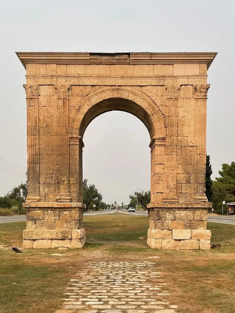
Quick facts
- Names: Arc de Berà in Catalan; often written Arc de Barà or, in Spanish, Arco de Bará. In English, the Arch of Berà.
- Where: N-340 at about km 1183, Roda de Berà (Tarragonès, Tarragona). Coordinates: 41.1733, 1.4691.
- Built: around 15–5 BC, at the end of the 1st century BC.
- Type: single-opening honorary arch of local limestone, with eight fluted pilasters and Corinthian capitals.
- Patron: Lucius Licinius Sura, by testament; probably dedicated to the Emperor Augustus or his genius.
- Status: part of the Archaeological Ensemble of Tarraco, a UNESCO World Heritage Site since 2000.
- Entry: free; it stands in the open by the road.
Access and parking
By car: the arch is on the N-340 between Tarragona and Torredembarra to the south and El Vendrell to the north. OpenStreetMap shows the road splitting into two one-way carriageways, each about 16–18 m from the monument, so the arch stands on an island in the middle. We found no mapped car park at the arch itself, so look for a safe place to stop in Roda de Berà rather than pulling up on the carriageway.
By bus: OpenStreetMap shows two sheltered bus stops within about 60 m of the arch, one on each side of the road.
On foot: take care crossing: the N-340 here carries fast traffic, with a 70 km/h limit on the carriageways next to the arch. Use crossings where they exist.
What to expect
A single stone arch standing on its own on a busy coast road. The Catalan Wikipedia, which draws on the research of archaeologist Xavier Dupré, describes it as a sober monument in large squared blocks (opus quadratum), set on two podiums. Two pilasters frame the arch on each face and two more mark the corners, all with fluted shafts and Corinthian capitals. The entablature carried an inscription: four of its blocks survive on the north face and name Lucius Licinius Sura, who left orders in his will for the arch to be built. The emperor himself is not named in what survives, though he may have been honoured in an inscription on the attic that once crowned the arch.
Who Sura was is debated. Older writers linked him with the senator of the same name who was a friend of the Emperor Trajan, which would date the arch much later. Recent research instead identifies him with a Lucius Sura recorded as prefect of the Roman colony of Colonia Victrix Iulia Lepida on coins of 39 BC, which fits the late 1st-century BC date of the building. The arch stood where the Via Augusta crossed the edge of Tarraco’s farmland, about 14 Roman miles from the city, and was probably linked to Augustus’s rebuilding of the road.
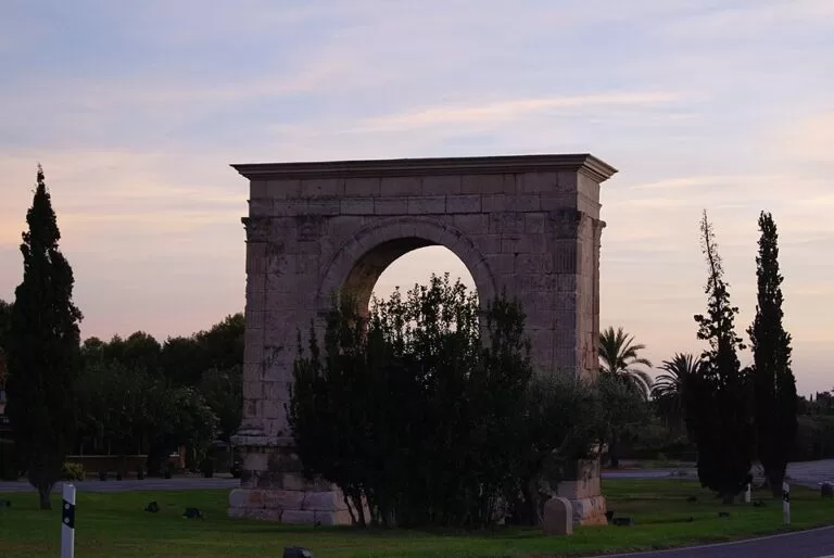
What you see is not quite Roman. The arch was already damaged when the artist Anton van den Wyngaerde drew it in 1563. A careful partial restoration in 1788 replaced worn blocks. In 1840 the governor of Tarragona had it rebuilt as an “Arch of Peace” dedicated to Queen Isabel II and General Espartero, which destroyed parts of the cornice, lost two of the six inscription blocks and painted the whole monument ochre. In July 1936 it was damaged in an attack and quickly shored up by the Catalan government’s monuments service. Today only four of the pilaster capitals are Roman. The present look dates from works inaugurated in May 1998, after research from 1984 to 1992 and excavations in 1994 and 1997.
The name: the earliest writer to discuss the arch, P. A. Beuter in 1538, tied it to a legendary figure called Bara and an improbable battle story. The arch has nothing to do with him; the name simply came to be shared with the town, Roda de Berà.
Practical details
- Facilities: OpenStreetMap shows none at the arch itself, so plan stops in town.
- What to look for: the surviving inscription blocks with Sura’s name on the north face, and the four original Roman capitals.
- Combine with: Roman Tarragona (the amphitheatre and the National Archaeological Museum) about 19 km south-west, and the Roman villa of Centcelles.
Accessibility and safety
The arch sits between two busy carriageways of the N-340. Do not stop on the road, watch children closely, and cross only where it is safe. The ground around the monument is level, but we could not confirm a step-free path from the bus stops.
Best time to visit
Any time of year: it is an outdoor monument with no opening hours. Avoid summer weekend afternoons, when the coast road is at its busiest, if you want a calmer stop.
Nearby alternatives
- Altafulla, 8.3 km away: a village and beach south-west along the coast.
- Tarragona Amphitheatre, 18.8 km away: another part of the UNESCO-listed Tarraco, by the sea.
- National Archaeological Museum of Tarragona, 18.7 km away: the finds from Roman Tarraco.
- Roman Villa of Centcelles, 20.4 km away: a Roman villa inland from Tarragona.
- Tarragona, 19.8 km away: the city guide.
Straight-line distances from the arch.
FAQ
Where is the Arc de Berà?
On the N-340 at Roda de Berà, about 20 km north-east of Tarragona, on the line of the Roman Via Augusta. Coordinates: 41.1733, 1.4691.
Is the Arc de Berà free to visit?
Yes. It stands in the open between the two carriageways of the road, with no ticket or fence.
Is there parking at the Arc de Berà?
We found no mapped car park at the arch. Park safely in Roda de Berà and walk, or use the bus stops beside the monument.
Who built the Arc de Berà?
It was built around 15–5 BC on the orders, in his will, of Lucius Licinius Sura, a Roman citizen probably living in Tarraco, and was probably dedicated to Augustus.
Is the Arc de Berà a UNESCO site?
Yes. It is one of the monuments of the Archaeological Ensemble of Tarraco, inscribed on the World Heritage List in 2000.
Sources and freshness
Checked 6 November 2026 · 3 sources Show
Checked 6 November 2026. History, restorations and description: Wikipedia (Catalan) and Wikipedia (Spanish). The official sites of the museum, Roda de Berà town hall and the Costa Daurada tourist board could not be opened when we checked. Location, road layout, bus stops, UNESCO reference and distances: OpenStreetMap contributors (ODbL). Photos: Wikimedia Commons, licences as credited.
This place is part of our Costa Dorada map and travel guide: Roman Tarragona, Salou and the Ebro Delta — see every town, beach and cove we have mapped on that coast.
How this page is made. CostaMap is written with an AI editorial system run by Ebizapple. This page is based on the sources listed above. Last updated 6 November 2026. Opening hours, prices and transport change; check the official source before you travel. How we work · Partner links and ads