
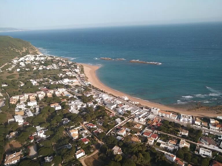
Los Caños de Meca is a small beach village in the municipality of Barbate (Cádiz), right beside Cape Trafalgar, about 8 km west of Barbate town and 14 km south of Vejer de la Frontera. Its beaches run for about 3 km, from the open sand and dunes of the cape to the cliffs of the Breña natural park, where freshwater springs, the caños that give the place its name, run down the rock to the sea. It suits people who want a laid-back beach with walks and history; skip it if you need a promenade, resort hotels or easy parking in August.
Quick facts
- Names: Los Caños de Meca, often just Caños de Meca or Los Caños; with neighbouring Zahora, on the other side of the cape, it is often treated as one place, Caños de Meca–Zahora.
- Where: Barbate municipality, province of Cádiz, at the foot of Monte de Meca; 8 km west of Barbate, 8 km south-east of Conil and 14 km south of Vejer (Spanish Wikipedia).
- Coordinates: 36.1866, -6.0268 (main beach, by the village).
- Beach: the sand mapped as Playa de los Caños de Meca runs for about 2.9 km east to west (OpenStreetMap); some sections are naturist.
- Population: 295 in 2015 (Spanish Wikipedia).
- Protected areas: the cliffs and pine forest are part of the Breña y Marismas del Barbate natural park (created 1989, 5,077 ha); the cape is protected as the Tómbolo de Trafalgar natural monument.
- Entry: free.
Access and parking
By car: the village lies on the A-2233 road (OpenStreetMap), between Barbate and Conil; Spanish Wikipedia gives 8 km to each.
Parking: OpenStreetMap shows a free car park about 700 m east of the main beach, near the bus stop on Avenida Trafalgar, and paid car parks for customers of local businesses about 330–370 m north of the beach. Spaces are few for the number of summer visitors, so arrive early in July and August.
By bus: OpenStreetMap marks a stop called “Av. Trafalgar (Los Caños de Meca)”, served by the regional coach company Transportes Generales Comes. We could not confirm the current timetable.
What to expect
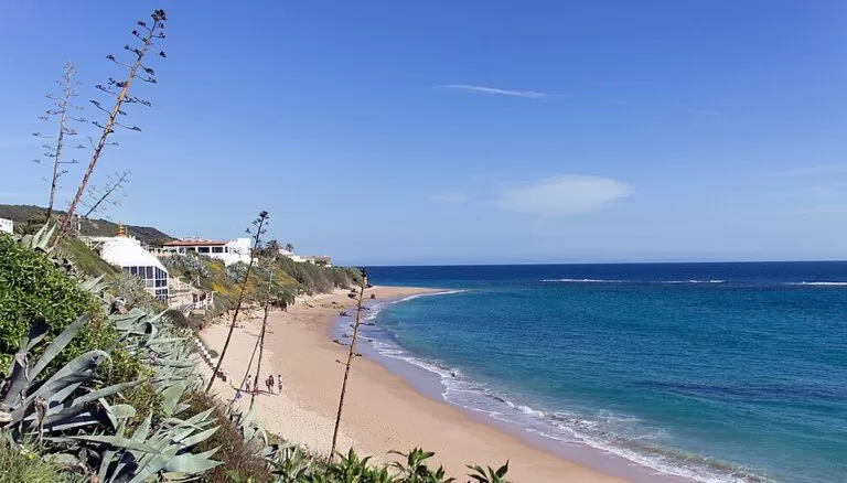
Spanish Wikipedia describes three kinds of beach. Towards Cape Trafalgar the beaches are open and flat, with fine sand and dunes broken by reefs. In front of the village the ground starts to rise and the beaches are smaller, sheltered by rock walls. Beyond that, under the cliffs of the natural park, there are small coves you can reach only at low tide, and only as far as the cove called Cala Verde.
The caños. Along the cliffs east of the village, fresh water seeps and pours out of the rock face. The Breña park’s cliff is made of calcarenite with layers of sandy marl that water cannot pass through, so the springs come out at different heights. Their flow changes a great deal with the season and rainfall. The biggest, the Caño Grande, lies near the end of the cliffs and is hard to reach, only at low tide (Spanish Wikipedia).
The name. A text from 1590 describes a famous spring here, “the waters of Meca”, visited by Moorish pilgrims. That spring is the most likely origin of the name.
Trafalgar. The Battle of Trafalgar was fought off Los Caños de Meca in 1805 (Andalusia tourism). The Trafalgar lighthouse stands on the cape, under 1 km west of the main beach, and OpenStreetMap marks Roman baths and Roman salting tanks near the cape, as well as a megalithic tomb.
The village. In the 1960s Los Caños became a meeting place for hippies drawn by the landscape (Spanish Wikipedia). It is still small and low-rise, with houses spread among the pines.
Practical details
- The natural park: the Breña y Marismas del Barbate park covers 5,077 ha, 1,152 of them at sea. Its cliff reaches 100 m above the sea at its highest point, where the 16th-century Torre del Tajo watchtower stands (Spanish Wikipedia).
- Birds: the cliffs hold colonies of herring gulls and cattle egrets, as well as little egrets, rock doves and jackdaws.
- Naturism: some of the beaches are naturist (Spanish Wikipedia); follow the signs on site.
- Services: we could not confirm lifeguard cover or official beach facilities; bring water and shade.
Accessibility and safety
The cliff coves are reachable only at low tide, and the tide can cut you off on the way back: check tide times and turn round early. Do not sit right under the cliff, because the rock breaks off in large blocks. The main beach by the village is the easiest access; we could not confirm a step-free route to the sand. Check wind and sea conditions before you swim.
Best time to visit
June and September give warm weather with fewer people than July and August, when parking is hardest. For the caños and the cliff coves, go at low tide; how much water the springs carry depends on the season and on recent rain.
Nearby alternatives
- Barbate, 9.4 km away: the fishing town at the other end of the Breña cliffs, known for its tuna.
- Vejer de la Frontera, 9.4 km away: the town inland, to the north.
- Conil de la Frontera, 11.5 km away: the beach town to the north-west.
- Playa de Bolonia, 26.3 km away: a beach further south-east, towards Tarifa.
- Chiclana de la Frontera, 28 km away: a town further north on the Cádiz coast.
Distances are in a straight line from the main beach.
FAQ
Why is it called Los Caños de Meca?
“Caños” are the spouts of fresh water that run out of the cliffs onto the beach. “Meca” probably comes from a famous spring recorded in 1590 as “the waters of Meca”, visited by Moorish pilgrims.
Is there parking at Los Caños de Meca?
Yes, but not much. OpenStreetMap shows a free car park about 700 m east of the main beach and paid customer car parks nearby. In July and August, arrive early.
Can you swim at Los Caños de Meca?
Yes. The beaches by the village are partly sheltered by rock walls. Check wind and sea conditions on the day, and remember that the cliff coves are only reachable at low tide.
Is Los Caños de Meca a nudist beach?
Some of its beaches are naturist, according to Spanish Wikipedia. Follow the signs on site to see which stretch is which.
How far is Cape Trafalgar from Los Caños de Meca?
The Trafalgar lighthouse is under 1 km west of the main beach, so you can walk there along the coast.
Sources and freshness
Checked 6 November 2026 · 4 sources Show
Checked 6 November 2026. Official: Andalusia tourism on Barbate (the beaches, the springs, the Battle of Trafalgar). Background: Spanish Wikipedia on Los Caños de Meca (location, beaches, caños, name, history) and La Breña y Marismas del Barbate natural park (size, cliff, Torre del Tajo, birds). Location, beach length, parking, bus stop, archaeological sites and distances: OpenStreetMap contributors.
This place is part of our Costa de la Luz, Spain: beaches, towns, sherry and map — see every town, beach and cove we have mapped on that coast.
How this page is made. CostaMap is written with an AI editorial system run by Ebizapple. This page is based on the sources listed above. Last updated 6 November 2026. Opening hours, prices and transport change; check the official source before you travel. How we work · Partner links and ads