
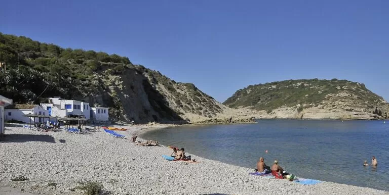
Cala del Portitxol, also called Cala Barraca or La Barraca, is a pebble and boulder cove in the south-east of Xàbia (Jávea), between the headlands of Cap Prim and Cap Negre. The Illa del Portitxol sits about 300 m offshore, and a row of white fishermen’s houses lines the beach. In summer the town limits car access and charges for parking: in 2026, 9 euros a day for one of 59 spaces. It suits snorkellers, swimmers and walkers who arrive early. Skip it if you want soft sand, a bus to the beach or an easy afternoon arrival in August.
Quick facts
- Names: Cala Barraca o Portitxol on the town’s tourism site; Platja de la Barraca on OpenStreetMap.
- Where: Portitxol Bay, between Cap Prim (north) and Cap Negre (south), Xàbia (Alicante), Marina Alta. Reached along the Cabo de la Nao road and the Carrer de la Barraca.
- Coordinates: 38.7529, 0.2240.
- Length: 900 m (Xàbia tourist office).
- Surface: gravel, boulders and pebbles. No sand.
- Average occupancy: high, according to the tourist office.
- Protection: since May 1999 the Valencian government has protected the beaches as a flora microreserve, one of two in the bay (the other is Cap Prim).
- Services listed: restaurant, bar, toilets, lifeguards, buoy markers, hammocks and sunshades.
- Summer parking 2026: 9 euros per vehicle per day, 59 spaces, no booking.
Access and parking
By car: the tourist office says you reach the cove by car from the Cabo de la Nao road. The last part runs down the Carrer de la Barraca through the Mar Blau estate (OpenStreetMap).
Summer rules, 2026. Xàbia controls access to its two busiest coves, Granadella and Barraca-Portitxol. These are the 2026 rules from the town’s coves access page (checked November 2026):
- Regulated access: every day from 2 June to 13 September, then weekends and bank holidays from 14 September to 12 October.
- Paid parking: every day from 2 June to 6 September, then weekends and bank holidays from 7 to 27 September.
- Hours 9:00 to 19:00. Price 9 euros per vehicle per day. You cannot book.
- 59 spaces in the Calle de la Barraca. There are two ticket machines at each cove.
- Signs on the way in show how many spaces are free. They stand at the Consum roundabout, at the Barraca street junction and at the Trovador restaurant.
- Motorbikes and vehicles for people with reduced mobility park free, but only in their marked area.
- Cars parked badly or without a ticket are fined and may be towed.
The same page says a barrier closes the last stretch of road to all vehicles except reduced-mobility vehicles, ambulances and authorised activity companies. It names that stretch as the Av. del Tío Catalá, which OpenStreetMap shows on the Granadella side. We could not confirm exactly where the barrier stands on the Barraca road, so follow the signs on the day.
Other parking: OpenStreetMap shows a small car park by the beach end of the Carrer de la Barraca, about 90 m from the pebbles. It also shows a free car park on the Carretera del Portitxol near the Creu del Portitxol viewpoint, about 640 m away in a straight line.
On foot: the tourist office says you can walk down from the Mirador de la Cruz del Portitxol (Creu del Portitxol), about 600 m from the beach in a straight line. Two signed local paths start at that viewpoint. The SL CV-98 goes down to Cala Barraca and the SL CV-97 goes out to Cap Prim (Xàbia tourism).
Without a car: the town states plainly that no public transport runs to La Barraca. The summer tourist train only serves Granadella.
What to expect
A rustic cove in a bay ringed by cliffs covered with Mediterranean vegetation. The northern cliffs are marl and clay, softer and lower than the limestone found elsewhere on Xàbia’s coast. They are grey and yellow, with fallen blocks along their base. At the southern end, Cap Negre is limestone with vertical walls, caves and underwater cracks (Xàbia tourism).
The Illa del Portitxol fills the view from the beach. The regional tourism board recommends it for scuba diving and notes its botanical and archaeological interest. The cove is a snorkelling spot. The town points to the brown algae (Cystoseira) that grow among the boulders as a sign of clean water. The white houses on the shore are the cove’s best-known sight (Comunitat Valenciana).

Practical details
- Food: OpenStreetMap lists Restaurante La Barraca and Cala Clemence on the Carrer de la Barraca, both within about 150 m of the beach. We did not check their opening hours or prices.
- On the beach: the tourist office lists hammocks and sunshades, canoeing and buoy markers. Bring water shoes for the pebbles.
- Entry: the beach is free. Only parking is charged in summer.
- Protected flora: the beaches are a plant microreserve. Stay on paths on the slopes and leave plants alone.
Accessibility and safety
The beach is all pebbles and boulders, and the walk from the viewpoint is a hillside path. We could not confirm any step-free route onto the beach. Reduced-mobility vehicles may pass the summer barrier and use their own parking area. The regional board lists lifeguards, but we could not confirm the 2026 season or hours. The Red Cross sea-conditions report is linked from the town’s beach page; check it before you swim out towards the island.
Best time to visit
Early morning, or outside the paid season. Both the town and the regional board call occupancy high and advise arriving early. With only 59 paid spaces in summer, late arrivals may find nowhere to park. The 2026 controls ended on 12 October; outside the season, pick a calm day for snorkelling.
Nearby alternatives
- Cap de la Nau (Cabo de la Nao), 2.3 km away: the cape viewpoint south of the bay.
- Cala Granadella (Jávea), 3.6 km away: the other controlled cove, with a summer tourist train from La Guàrdia.
- Cap de Sant Antoni (Jávea), 6.1 km away: the northern cape, a protected reserve.
- Jávea (Xàbia) town guide, 6.5 km away: the old town, the port and the Arenal beach.
- Cala del Moraig (El Poble Nou de Benitatxell), 6.9 km away: another cove, further south in Benitatxell.
Distances are in a straight line from the cove.
FAQ
Are Cala Barraca and Cala del Portitxol the same place?
Yes. Xàbia’s tourist office lists it as Cala Barraca o Portitxol. Portitxol is also the name of the bay and of the island in front of the cove.
Can I drive to Cala Barraca in summer?
Yes, but access is controlled. In 2026 access is regulated daily from 2 June to 13 September. Parking costs 9 euros a day from 9:00 to 19:00 from 2 June to 6 September, with 59 spaces and no booking. Signs on the approach show how many spaces are free.
Is there a bus to Cala Barraca?
No. The town says no public transport serves La Barraca. Come by car, taxi, bike or on foot from the Creu del Portitxol viewpoint.
Is it a sandy beach?
No. It is gravel, pebbles and boulders, 900 m long. Water shoes help.
Is it good for snorkelling?
Yes. Both the town and the regional tourism board recommend it, with rocky bottoms around the bay and the Illa del Portitxol about 300 m out.
Sources and freshness
Checked 6 November 2026 · 5 sources Show
Checked 6 November 2026. Official: Xàbia tourism (town council) on Cala Barraca o Portitxol (length, surface, occupancy, services, access), coves access information 2026 (access dates, parking, price, spaces, public transport) and Portitxol Bay (geology, microreserves, paths). Regional: Turisme Comunitat Valenciana (island, diving, services). Location, parking, restaurants, viewpoint and distances: OpenStreetMap contributors (ODbL). Photos: Wikimedia Commons, licences as credited.
This place is part of our Costa Blanca, Spain: towns, beaches and where to stay — see every town, beach and cove we have mapped on that coast.
How this page is made. CostaMap is written with an AI editorial system run by Ebizapple. This page is based on the sources listed above. Last updated 6 November 2026. Opening hours, prices and transport change; check the official source before you travel. How we work · Partner links and ads