
Flysch Route: Zumaia to Deba coastal walk
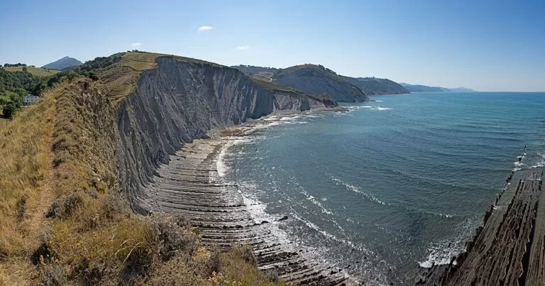
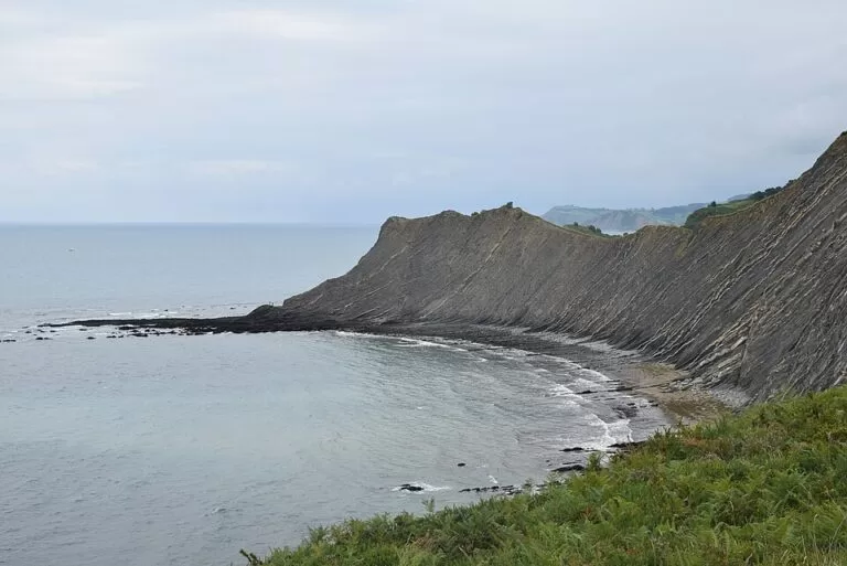
Hiking trailThe Flysch Route is the 13.5 km coastal walk from Zumaia to Deba in Gipuzkoa, along the cliffs of layered rock (flysch) of the Basque Coast UNESCO Geopark. It starts by the San Telmo hermitage above Itzurun beach in Zumaia, follows the waymarked GR 121, and ends in Deba; both towns have Euskotren stations, so you can walk one way. The Basque tourism board’s leaflet gives 13.5 km, 649 m of climbing and 4 h 45 min of walking. It suits fit walkers who like big views and geology. Skip it if you want an easy, flat stroll: the official leaflet calls it a beautiful but demanding stage with constant ups and downs.
Quick facts
- Names: Flysch Route or Flysch Trail (in Spanish Ruta del Flysch, in Basque Flysch ibilbidea). Officially this is the Zumaia–Deba stage of the Sendero Litoral, the Basque section of the European coastal path E9, which here follows the GR 121 “Sendero Talaia”.
- Where: between Zumaia and Deba, on the coast of Gipuzkoa (Basque Country).
- Start coordinates: 43.2990, -2.2612 (San Telmo hermitage, Zumaia, from OpenStreetMap).
- Distance: 13.5 km one way (official leaflet).
- Height gain: 649 m (official leaflet).
- Walking time: 4 h 45 min, without stops (official leaflet).
- Difficulty (MIDE): 1-2-2-3: some risk from the terrain, paths that need you to follow the waymarks, mule-track surfaces, and 3 to 6 hours of walking.
- Waymarking: red and white GR 121 marks.
- Entry: free.
Access and parking
By train: Zumaia and Deba both have stations on the Euskotren network (OpenStreetMap). Zumaia station is about 1.1 km in a straight line from the San Telmo hermitage. A simple plan is to walk Zumaia to Deba, the direction of the official description, and take the train back. Check Euskotren for current times.
Parking in Zumaia: on OpenStreetMap, most street parking in the streets around San Telmo is marked for permit holders only. The nearest public spaces mapped are paid on-street spaces about 450–500 m from the hermitage. We could not confirm prices or summer rules.
Starting in Deba: you can also walk it the other way, from Deba to Zumaia. The official leaflet describes it from Zumaia.
What to expect
The route follows the official leaflet’s description (Sendero Litoral, stage 5, edition 2025):
- Km 0, Zumaia: follow San Telmo street up behind the Itzurun cliffs to the San Telmo hermitage, first recorded in 1540. Here the asphalt ends and a narrow path follows the rock layers.
- Km 1.2, Algorri viewpoint: after the first views the path turns inland with a steep climb to the Agirre farmhouses, joins the Camino de Santiago and crosses fields to the Elorriaga picnic area.
- Km 4.9, Elorriaga: a side path leads to the Baratzazarrak viewpoint. Leave the yellow Camino arrows before Elorriaga and stay on the GR.
- Km 7.8, Sakoneta beach: the path comes back to the coast at the Portutxiki balcony and Sakoneta. This is the section with the best views of the cliffs and the flysch, with several viewpoints.
- Km 11.7, Santa Katalina: after an old railway tunnel you cross the N-634 on a footbridge and climb to the Santa Katalina hermitage and lookout, rebuilt in neo-Gothic style in the 19th century.
- Km 13.5, Deba: the path goes down past the wooden porch of the San Roke hermitage and an old paved road into the town.
The coast of Mutriku, Deba and Zumaia has been part of the UNESCO Global Geoparks network since 2015. At Itzurun beach in Zumaia, two “golden spikes” (stratotypes) mark world reference points for two periods of geological time, the Selandian and the Thanetian.
Practical details
The official leaflet’s recommendations:
- Walk with someone, and tell others where you are going and when you will be back.
- Plan the stage to suit your fitness, and pace yourself: the ups and downs add up.
- Wear suitable shoes and clothes for the forecast.
- Carry water, food, a first-aid kit, a charged phone, money and ID.
- Check the tide table: the flysch is best seen at low tide, so time your walk to pass Sakoneta beach (km 7.8) near low water.
Tourist offices (from the leaflet): Zumaia 943 14 33 96, Deba 943 19 24 52.
If you would rather see the cliffs from the sea, the Basque tourism board lists a guided boat trip from Zumaia to Mutriku and back, about 3 h 30 min, in spring and summer (Tourism Euskadi).
Accessibility and safety
This walk is not suitable for wheelchairs or pushchairs: it uses narrow paths and mule tracks with steep climbs and descents. The leaflet warns that the terrain is not free of risk. Keep back from cliff edges, and if you go down to the rock platforms at Sakoneta, watch the tide so you are not cut off.
Best time to visit
The leaflet names no best season. Pick a dry forecast and time the walk so that you reach Sakoneta near low tide. Start early enough to finish the 4 h 45 min of walking, plus stops, in daylight.
Nearby alternatives
- Zumaia Flysch, 0.1 km away: our guide to the flysch cliffs and Itzurun beach at the start of the walk.
- Getaria, 4.7 km away: the fishing village east of Zumaia.
- Zarautz, 8.2 km away: the long surf beach further east.
- San Sebastián, 22 km away: the city and its bay.
- Bilbao, 55 km away: the city on the Nervión.
Distances are in a straight line from the San Telmo hermitage.
FAQ
How long is the Flysch Route from Zumaia to Deba?
13.5 km one way, with 649 m of climbing and about 4 h 45 min of walking, according to the official Basque leaflet.
How do I get back to Zumaia from Deba?
By train: both towns have Euskotren stations. Check current times before you set off.
Is there parking at the start in Zumaia?
Limited. Most street parking near the San Telmo hermitage is permit-only on OpenStreetMap; the nearest public spaces mapped are paid, about 450–500 m away. Arriving by train is simpler.
When is the best time to see the flysch?
At low tide. The leaflet recommends checking the tide table so you pass Sakoneta beach, at km 7.8, at low water.
Is the Flysch Route hard?
It is demanding. The official leaflet calls it beautiful but tough, with constant climbs and descents, and grades the effort 3 on the MIDE scale (3 to 6 hours of walking).
Sources and freshness
Checked 6 November 2026 · 3 sources Show
Checked 6 November 2026. Official: Basque Government tourism, Sendero Litoral leaflet, stage 5 Zumaia–Deba (edition 2025: distance, climbing, time, MIDE grade, route, tides, Geopark, tourist offices) and the Flysch boat route. The Geopark and Debabarrena tourism websites could not be reached from our research tools. Stations, parking, coordinates and distances: OpenStreetMap contributors (ODbL). Photos: Wikimedia Commons, licences as credited.
How this page is made. CostaMap is written with an AI editorial system run by Ebizapple. This page is based on the sources listed above. Last updated 6 November 2026. Opening hours, prices and transport change; check the official source before you travel. How we work · Partner links and ads