
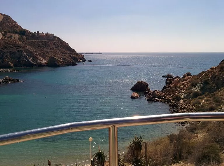
Cala Cortina is the nearest beach to Cartagena city: a 210 m cove of sand and gravel on the east side of the harbour mouth, about 4 km from the centre by road through the Santa Lucía district and a short tunnel. You can drive, walk or, in July and August, take the city’s summer beach bus. The cove has toilets, a children’s play area, sunbeds, a restaurant and a small islet a few metres offshore. It suits families and anyone staying in Cartagena who wants a swim without a long trip; skip it if you want space on a summer weekend, because it is one of the city’s most popular beaches.
Quick facts
- Name: Cala Cortina (Spanish cala means cove).
- Where: Santa Lucía district, Cartagena (Region of Murcia), on the coast road towards Escombreras, east of the harbour mouth.
- Coordinates: 37.5811, -0.9747.
- Size: 210 m long and 20 m wide (spain.info).
- Surface: golden sand and gravel, with rocks at both ends.
- Facilities: toilets, footwash, litter bins, cleaning service and children’s play area (spain.info); a promenade, sunbeds and parasols and a restaurant (Spanish Wikipedia).
- Occupancy: rated high by spain.info.
- Entry: free.
Access and parking
By car: from the city, follow the road round the port through Santa Lucía and through a tunnel to the cove (Spanish Wikipedia). Spain.info gives the distance as 4 km from Cartagena and names the Cartagena to Escombreras road as the nearest main road (spain.info). OpenStreetMap tags the approach road and the tunnel with a 3.5 m height limit and a 5.5 tonne weight limit, so large motorhomes and coaches cannot get through.
Parking: the viewpoint above the cove doubles as a car park (Spanish Wikipedia). OpenStreetMap shows two car parks 90–100 m from the sand, two disabled spaces beside the beach toilets, and a small car park for restaurant customers. None is tagged with a fee or capacity, and we could not confirm either. Spain.info rates occupancy as high, so expect them to fill early in summer.
By bus: line 12 of Cartagena’s urban buses, the “Bus Playa”, runs only in July and August, and since summer 2025 has had a direct route between the city and Cala Cortina. In busy years it can start in late June and run into September (Spanish Wikipedia on line 12). The stop, called Cala Cortina, is about 100 m from the sand. We could not confirm the 2026 timetable; check with the operator, ALSA (TUCARSA), before you go.
On foot: spain.info says a footpath leads directly to the beach, with views of the natural harbour and its cliffs. Note that OpenStreetMap marks the road tunnel itself as closed to pedestrians and cyclists, so follow the signed path rather than the tunnel. Information boards at the cove mark the Sendero Azul del Puerto de Cartagena, a walking route round the port.
By bike: OpenStreetMap shows bike stands for four bikes by the beach.
What to expect
A small, well-equipped city beach in a rocky setting. The water is clear and usually calm, though spain.info classes swimming conditions as moderate waves, so it is not always flat. A small natural islet sits a few metres off the beach, and people fish and dive from the rocks at both ends (Spanish Wikipedia). Snorkelling is best near those rocks on calm days.
Cala Cortina was turned from a rough cove into a serviced beach in stages: first works in the early 1990s, then an improvement programme for access and services that began in April 1998. In 2019 readers of Condé Nast Traveler voted it the second-best beach in Spain.
The headland above is full of military history. OpenStreetMap marks several old coastal batteries around the cove, including the Batería de Santa Ana, and viewpoints over the harbour mouth. The Castillo de San Julián stands on the hill 0.8 km to the east. Some land nearby is still military and closed to the public, so keep to marked paths.
Practical details
- OpenStreetMap shows a free drinking-water fountain at the top of the beach where you can refill a bottle.
- The beach toilet block is tagged as wheelchair accessible and unisex.
- The restaurant on the beach is listed on OpenStreetMap as Restaurante Mares Bravas. We could not confirm its opening hours or season.
- Sunbeds and parasols are available in summer (Spanish Wikipedia). We could not confirm 2026 prices.
- Bring water shoes if you plan to swim or snorkel from the rocks.
Accessibility and safety
Cala Cortina is one of the easier natural coves to reach: there are disabled parking spaces and an accessible toilet next to the sand, and spain.info rates foot access as easy. Steps lead down in places, and we could not confirm a step-free route onto the sand itself or an amphibious bathing chair. We could not confirm lifeguard dates for 2026. The tunnel is closed to walkers and cyclists, so do not walk through it.
Best time to visit
June and September, when the beach is usually less crowded than in July and August. On summer weekends arrive early for parking, or take the beach bus. Calm mornings are best for snorkelling near the islet and the rocks.
Nearby alternatives
- Castillo de San Julián, 0.8 km away: the fort on the hill above the harbour mouth.
- National Museum of Subaquatic Archaeology, 1.9 km away: Spain’s national underwater archaeology museum, on the Cartagena waterfront.
- Roman Theatre of Cartagena, 2.2 km away: the city’s best-known Roman site.
- Cartagena town guide: our guide to the city.
- Calblanque, 24.3 km away: the protected coast east of the city.
- Cabo de Palos, 24.5 km away: the village on the cape east of Cartagena.
Distances are in a straight line from the cove.
FAQ
How do I get to Cala Cortina from Cartagena?
By car or on foot round the port through Santa Lucía, about 4 km, or by the line 12 “Bus Playa” in July and August. The road passes through a short tunnel with a 3.5 m height limit.
Is there parking at Cala Cortina?
Yes. The viewpoint above the cove is used as a car park, and OpenStreetMap shows two car parks about 100 m from the sand plus two disabled spaces by the toilets. Arrive early in summer.
Is there a bus to Cala Cortina?
Yes, in summer. Line 12, the Bus Playa, runs in July and August with a direct route to Cala Cortina, sometimes from late June into September.
Can you swim at Cala Cortina?
Yes. The water is clear and usually calm, but spain.info classes conditions as moderate waves, so check the sea before you go in.
Is Cala Cortina good for children?
Yes. It has a play area, toilets, a footwash and a restaurant, and it is close to the city. It gets crowded in high season.
Sources and freshness
Checked 6 November 2026 · 4 sources Show
Checked 6 November 2026. Official: spain.info, Cala Cortina (Turespaña: size, surface, distance, access, services, occupancy). Background: Spanish Wikipedia on Cala Cortina (access, facilities, islet, history, Condé Nast vote) and line 12 (TUCARSA) (summer beach bus). Location, car parks, bus stop, tunnel limits, toilets and distances: OpenStreetMap contributors (ODbL). The Cartagena town hall, Cartagena tourism and Murcia regional tourism websites could not be reached when we checked. Photos: Wikimedia Commons, licences as credited.
How this page is made. CostaMap is written with an AI editorial system run by Ebizapple. This page is based on the sources listed above. Last updated 6 November 2026. Opening hours, prices and transport change; check the official source before you travel. How we work · Partner links and ads