
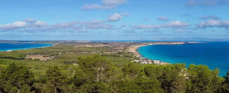
Formentera is the smallest and most southerly of the Balearic Islands, just south of Ibiza: about 83 km² and some 20 km from end to end. It has no airport, so everyone arrives by ferry, most from Ibiza town to the port of La Savina, a crossing of about 30 minutes with sailings all year. The draw is the beaches, above all Ses Illetes and Llevant on the Es Trucadors sandspit, plus the cliffs at La Mola and Cap de Barbaria and a network of flat, signed bike and walking routes. It suits beach lovers, cyclists and families who like a quiet pace; skip it if you want nightlife, big resorts or cheap summer prices.
Quick facts
- Names: Formentera in Catalan, Spanish and English; the Latin name was Frumentaria, “the wheat island”.
- Where: Balearic Islands, south of Ibiza. One municipality; the main town is Sant Francesc, and the ferry port is La Savina.
- Coordinates: 38.7062, 1.4334 (centre of the island).
- Size: about 83 km², roughly 20 km from end to end (Formentera tourist board).
- Highest point: Sa Talaïassa, 192 m, on the La Mola plateau at the east end.
- Protection: the north of the island, including Ses Illetes and Llevant, lies in the Ses Salines d’Eivissa i Formentera natural park.
- Tourist offices: Sant Francesc, La Savina and Es Pujols.
Access and getting around
By ferry: ferries leave the port of Eivissa (Ibiza town) and reach La Savina in about 30 minutes, with frequent sailings all year (Formentera tourist board). Most visitors fly to Ibiza airport first. In the season there is also a direct connection with the Spanish mainland. We did not check 2026 fares or timetables, which vary by company and season.
By car: in high season, vehicle access to the island is regulated to protect the environment, says the tourist board. We could not confirm the 2026 rules; check before you bring or hire a car.
By bike and on foot: the island is flat and distances are short. The tourist board lists 32 signed “green routes”, many suitable for bikes. Examples:
- La Savina – Ses Illetes: 3.3 km.
- La Savina – Sant Francesc – Es Pujols: 5.6 km.
- La Savina – Cala Saona: 5.5 km.
- Sant Francesc – La Mola: 9 km.
- Camí de sa Pujada (the “Roman path” up to La Mola): 4 km.
By bus: the public bus covers the longer trips, such as the climb to La Mola (tourist board). For the natural park, the Balearic government lists bus line 3 from La Savina.
What to expect
Formentera is low and long: the La Mola plateau at the east end, dry Cap de Barbaria in the south-west, and the Es Trucadors peninsula pointing north towards Ibiza.
Beaches (all from the tourist board’s beach pages):
- Ses Illetes: over 450 m of white sand on the west side of Es Trucadors, in the natural park, with shallow, calm water, boardwalks over the dunes, set parking areas and several restaurants.
- Llevant: 1,450 m of sand on the east side of the same peninsula, with almost no buildings; in places it is only 50 m from Ses Illetes.
- Migjorn: 5 km of beaches along the south coast, sheltered from the prevailing summer winds, with hotels and beach bars.
- Cala Saona: a 140 m sandy cove between the cliffs of the west coast, with parking at the end of the road and some of the island’s best sunsets.
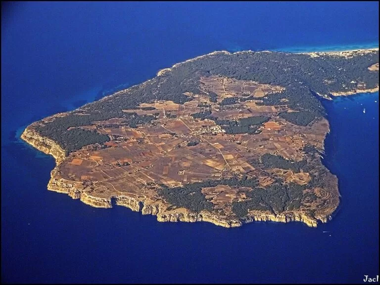
Cliffs and lighthouses: the Far de la Mola stands on a cliff 120 m above the sea, next to a monument to Jules Verne. Since 2026 it holds a permanent exhibition of 56 works by artists linked to the island. The Cap de Barbaria lighthouse sits on a 100 m vertical cliff at the island’s southern tip, the point of the Balearics closest to Africa; it is a sunset spot with views to Es Vedrà, and nearby are the Cova Foradada and the Torre des Garroveret watchtower.
History: the megalithic tomb of Ca na Costa dates from about 2000–1600 BC. The island was almost empty from the 14th to the 17th century because of plague and pirate raids, and was resettled from 1697 (tourist board).
Nature: about 85% of the Ses Salines natural park is sea, mostly Posidonia seagrass meadows that UNESCO listed as World Heritage in 1999. Some 210 bird species have been counted in the park, and the Estany Pudent lagoon holds one of Europe’s largest gatherings of black-necked grebes (Balearic government).
Practical details
- Far de la Mola exhibition: €4.50; €2.50 for pensioners and students; free for residents, under-18s and unemployed people. From 15 October to 30 November it opens Tuesday to Sunday, 9:00–14:00, and it closes from 1 December to 11 February (checked November 2026).
- Can Marroig: the natural park’s interpretation centre on Formentera. Drive the signed dirt track from the La Savina – Sant Francesc road to the car park of the picnic area, then continue on foot or by bike.
- Viewpoint: just before the top of the road up to La Mola, after Es Caló, there is a viewpoint by a restaurant with easy parking, looking over both coasts.
- Emergencies: 112; Hospital de Formentera, tel. 971 32 12 12.
Accessibility and safety
The island is flat outside La Mola, which makes cycling and walking easy, but summer sun is strong and shade on the beaches is limited. We could not confirm step-free access at specific beaches or on the ferries; ask the ferry company and the tourist office. The cliffs at La Mola and Cap de Barbaria have sheer drops: stay back from the edge, and take great care at the Cova Foradada, which the tourist board says you enter through a hole in the rock.
Best time to visit
For swimming, May to October. The tourist board says May, June and September give the best balance of good weather and fewer people. Summer (June to September) is hot and dry, with highs of 28–31 °C and the biggest crowds. The sea is coldest in winter at 15–16 °C and warmest at the end of summer at 26–27 °C. Spring suits walking and cycling. In winter some businesses cut back, and the Far de la Mola is closed from December to mid-February.
Nearby alternatives
- Ses Illetes, 5.8 km from the centre of the island: Formentera’s best-known beach.
- Dalt Vila, 22 km away: the walled old town above Ibiza port, where the ferries leave.
- Cala d’Hort, 27 km away on Ibiza: the beach facing Es Vedrà.
- Cala Comte, 34 km away: shallow sandy coves on Ibiza’s west coast.
- Es Vedrà, 27 km away off Ibiza: the rock island you see at sunset from Cap de Barbaria.
- S’Espalmador, 8.9 km away: the small island just off the northern tip of Es Trucadors.
Distances are in a straight line from the centre of Formentera.
FAQ
How do I get to Formentera?
By boat only: there is no airport. Ferries run from Ibiza town to La Savina in about 30 minutes, all year.
Do you need a car on Formentera?
No. The island is about 20 km long and mostly flat, with 32 signed green routes for walking and cycling and a public bus. In high season vehicle access to the island is regulated.
What is the best beach on Formentera?
Ses Illetes is the best known: shallow, turquoise water and white sand inside the natural park. Llevant, on the other side of the same peninsula, is quieter; Migjorn and Cala Saona are good alternatives.
When is the best time to visit Formentera?
May to October for swimming; May, June and September for good weather with fewer people, says the tourist board.
Can you do Formentera as a day trip from Ibiza?
Yes. The crossing takes about 30 minutes and ferries are frequent; from La Savina, cycle or take the bus to the beaches.
Sources and freshness
Checked 6 November 2026 · 14 sources Show
Checked 6 November 2026. Official: Formentera tourist board (Consell Insular de Formentera): where it is (size, ferry, geography, climate, best time), transport, green routes, history, Ses Illetes, Llevant, Migjorn, Cala Saona, Far de la Mola (hours, prices), Cap de Barbaria, viewpoints and health and safety. Balearic government, Ses Salines natural park (park, birds, Can Marroig, bus). Location and distances: OpenStreetMap contributors (ODbL). Photos: Wikimedia Commons, licences as credited.
How this page is made. CostaMap is written with an AI editorial system run by Ebizapple. This page is based on the sources listed above. Last updated 6 November 2026. Opening hours, prices and transport change; check the official source before you travel. How we work · Partner links and ads