
Mirador de la Creu del Portitxol (Jávea)
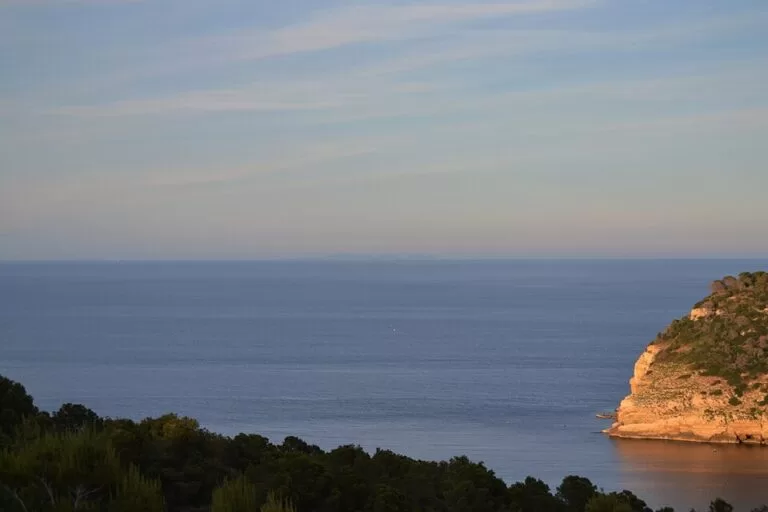
ViewpointThe Mirador de la Creu del Portitxol is the viewpoint by a stone cross above Portitxol Bay in Xàbia (Jávea), looking out over the Illa del Portitxol and down to Cala Barraca. It sits 87 m above the sea, with two small free parking areas beside it, and is the start of the signposted SL-CV 97 path down to the cove (765 m, about 11 minutes). It suits anyone who wants the classic Portitxol view without the summer parking charge at the cove; skip it if you want a long walk, as the viewpoint itself is a short stop.
Quick facts
- Names: Creu del Portitxol (Valencian, “Portitxol Cross”); in Spanish Mirador de la Cruz del Portitxol. One of the 15 viewpoints on Xàbia’s “Ruta de los Miradores” (Xàbia tourist office).
- Where: above Portitxol Bay, off the Carretera del Portitxol (CV-742), Xàbia, Marina Alta (Alicante).
- Coordinates: 38.7565, 0.2190.
- Height: 87 m above sea level (SL-CV 97 leaflet, Xàbia tourist office).
- What you see: the Illa del Portitxol, an islet about 300 m across; Cala Barraca below; Cap Prim to the north and Cap Negre to the south.
- Path to the cove: SL-CV 97, 765 m down to Cala Barraca, 1,530 m there and back, about 45 minutes, low difficulty.
- Entry and parking: free (OpenStreetMap marks the two parking areas as free).
Access and parking
By car: the viewpoint lies a short way off the Carretera del Portitxol (CV-742), reached through residential streets (OpenStreetMap). The tourist office describes Cala Barraca below it as reached by car from the Cabo de la Nao road. The Xàbia tourist office map pin for the viewpoint is at 38.75649, 0.21898, which matches the OpenStreetMap point by the cross.
Parking: OpenStreetMap shows two small free parking areas beside the viewpoint, about 40 m and 100 m from the cross. This matters in summer: in 2026 the town charged 9 euros a day for the 59 spaces at Cala Barraca from 2 June to 6 September daily and on weekends until 27 September, from 9:00 to 19:00 (Xàbia tourist office, checked November 2026). The cross is the walkers’ way in: the tourist office says the cove can be reached “on foot from the scenic viewpoint” (Xàbia tourist office).
Without a car: the tourist office states that no public transport serves La Barraca, and we found no bus route to the viewpoint either. Plan on a car, a bike or a taxi.
What to expect
A stone cross on a stepped base, with a low wall and pines around the lookout, as shown in the tourist office’s path leaflet. In front of you is the Illa del Portitxol. The tourist office describes it as “the barge run aground just a few meters away”: an islet about 300 m across that was once inhabited, where burial sites have been found (Xàbia tourist office). The path leaflet adds that archaeological remains from the 7th–6th centuries BC have been found in the waters here, though most finds, including amphorae for wine and oil, are Roman.
The cross stands in a spot that was a natural mooring in ancient times. Portitxol means “little port”, and in the past it was a haven for small trading boats sailing the Mediterranean. Below, Cala Barraca takes its name from the fishermen’s huts (barracas) that once had thatched roofs; they have been altered but still stand.
The bay itself is unusual for Xàbia. Its northern part is mostly marlstone and clay rather than the limestone of the rest of the coast, so the cliffs are lower and grey-yellow, with fallen blocks along the shore. To the south, Cap Negre rises in vertical limestone walls. Because of the plants here, the Valencian government created two flora micro-reserves in May 1999, at Cap Prim and at the Portitxol or Barraca beaches (Xàbia tourist office).
The path down to Cala Barraca (SL-CV 97)
The signposted SL-CV 97 path starts at the cross. The Xàbia tourist office leaflet (published 2008) describes it like this (SL-CV 97 leaflet, PDF):
- Start at the Creu del Portitxol lookout (87 m) and take the footpath from the cross. Where paths cross, keep right. The path runs through evergreen buckthorn, cat’s claw, carob trees and pines.
- After a small pine wood, at 510 m (about 7 minutes, 45 m above sea level), the path forks: Els Pallers to the left, Cala Barraca to the right. Go right, down a few steps and along a fence.
- After several flights of steps you reach the cove at 765 m (about 11 minutes).
- Return the same way: 1,530 m and 45 minutes in all, with 87 m to climb back up. Difficulty: low.
The leaflet’s advice: avoid the midday sun, and the emergency number is 112. OpenStreetMap shows a route information board and a guidepost by the cross.
Accessibility and safety
The lookout is next to the parking areas. We could not confirm step-free access to the cross itself. The path down to the cove has several flights of steps and an 87 m climb back, so it is not suitable for wheelchairs or pushchairs. Take water, and follow the leaflet’s advice to avoid the midday sun.
Best time to visit
The tourist office rates average occupancy at Cala Barraca as high, so the parking areas at the cross also fill in summer. In 2026 regulated access to the cove ran daily from 2 June to 13 September and at weekends until 12 October; outside those dates there is less pressure on parking. For the walk down, follow the leaflet and avoid the middle of the day in summer.
Nearby alternatives
- Cala del Portitxol (Cala Barraca), 0.6 km away: the pebble cove at the end of the SL-CV 97 path.
- Illa del Portitxol, 0.9 km away: our guide to the island you see from the cross.
- Cap de la Nau, 2.8 km away: another viewpoint, at the cape to the south-east.
- Cala Granadella, 3.7 km away: Xàbia’s other regulated cove, with a summer tourist train from La Guàrdia car park.
- Cap de Sant Antoni, 5.5 km away: the viewpoint at the northern end of Xàbia’s bay.
Distances are in a straight line from the cross.
FAQ
Where is the Creu del Portitxol in Xàbia?
Above Portitxol Bay in Xàbia, a short way off the Carretera del Portitxol (CV-742). Coordinates: 38.7565, 0.2190.
Is there parking at the Creu del Portitxol?
Yes. OpenStreetMap shows two small free parking areas beside the cross, about 40 m and 100 m away.
How do I walk from the Creu del Portitxol to Cala Barraca?
Follow the signposted SL-CV 97 path from the cross. It is 765 m down to the cove, about 11 minutes, with steps at the end; allow 45 minutes for the round trip.
Do you have to pay to park for Cala Barraca?
At the cove itself, in the 2026 season, yes: 9 euros a day for 59 spaces on Calle de la Barraca. The parking at the cross is marked as free on OpenStreetMap.
What is the island you see from the cross?
The Illa del Portitxol, an islet about 300 m across that was once inhabited and has archaeological remains.
Sources and freshness
Checked 6 November 2026 · 7 sources Show
Checked 6 November 2026. Official, Xàbia tourist office: Creu del Portitxol (description, map pin), scenic viewpoints route, Cala Barraca, Portitxol Bay, cove access 2026 (parking, dates, price, public transport) and the SL-CV 97 Cala Barraca leaflet (2008; height, path, history). Location, parking, signposts and distances: OpenStreetMap contributors (ODbL). Photos: Wikimedia Commons, licences as credited.
This place is part of our Costa Blanca, Spain: towns, beaches and where to stay — see every town, beach and cove we have mapped on that coast.
How this page is made. CostaMap is written with an AI editorial system run by Ebizapple. This page is based on the sources listed above. Last updated 6 November 2026. Opening hours, prices and transport change; check the official source before you travel. How we work · Partner links and ads