
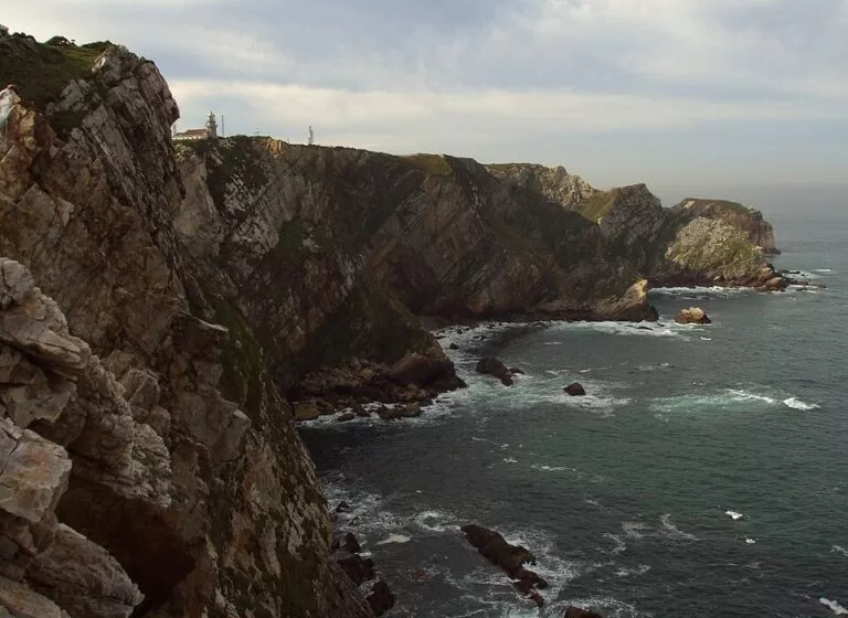
Cabo de Peñas (Cabu Peñes in Asturian) is the northernmost point of Asturias: a headland in the municipality of Gozón, between Gijón and Avilés, where cliffs up to 100 m high drop into the Bay of Biscay. You drive the AS-328 to the end, park for free beside the lighthouse and walk out on a wooden boardwalk to several viewpoints; the lighthouse houses a small maritime museum. It suits anyone touring the Asturian coast, birdwatchers and families; skip it on a day of thick fog if you came for the view.
Quick facts
- Names: Cabo de Peñas or Cabo Peñas (Spanish), Cabu Peñes or Peñes (Asturian), Cape Peñas. The lighthouse is the Faro de Cabo de Peñas (Faru de Peñes).
- Where: end of the AS-328 (Carretera Avilés – Cabo Peñas), Gozón, Asturias. About 5.7 km north-west of Luanco.
- Coordinates: 43.6557, -5.8485 (lighthouse).
- Cliffs: up to 100 m; the cape is a flat coastal shelf (rasa costera) about 100 m above the sea.
- Protection: Cabo Peñas Protected Landscape, 1,926 ha, and part of Natura 2000 as a Special Area of Conservation and Special Protection Area for Birds.
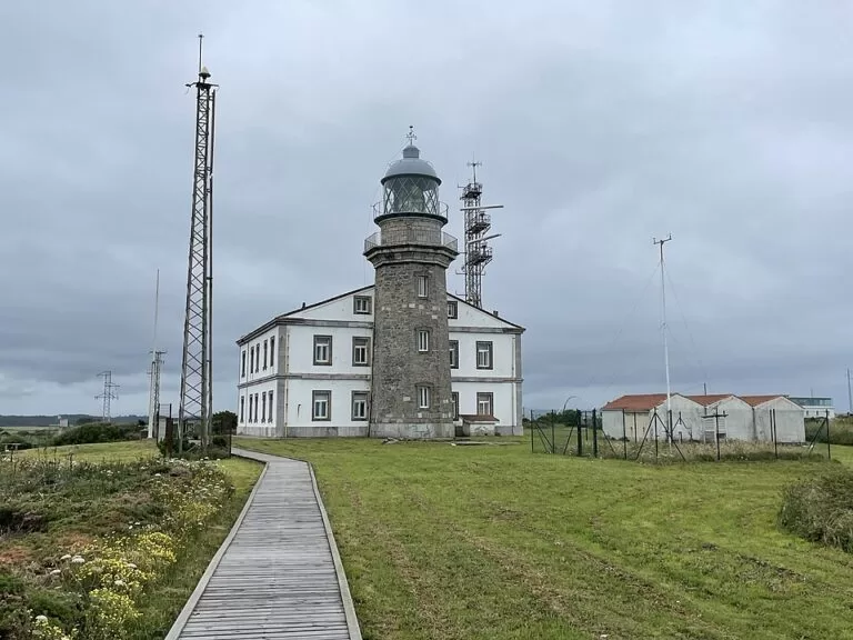
- Lighthouse: a first watchtower with a small light from 1852; the present tower from 1929; fog sirens added in 1971; a resident keeper until 2021.
- Entry to the viewpoints: free. Parking is free (OpenStreetMap).
Access and parking
By car: the AS-328 runs from the Avilés side to the cape and ends at the lighthouse. Asturias tourism’s lighthouse route reaches it past the beaches of Xagó and Verdicio, then continues to Luanco and Candás (Turismo Asturias, lighthouse route stage 3).
Parking: OpenStreetMap shows two free surface car parks, one about 110 m south of the lighthouse and one about 150 m east of it, by the boardwalk.
By bus: OpenStreetMap places a stop called Peñes, in the Asturias public transport consortium (CTA) network, about 130 m from the lighthouse. We could not confirm which line serves it or how often, so check the CTA timetable before relying on it.
On foot: a self-guided trail with five stops starts at the information point of the protected landscape and loops round the cape past the lighthouse (Turismo Asturias, “Peñas self-guided trail”).
What to expect
A wide, green clifftop with the stone lighthouse tower and its white keeper’s house in the middle, a wooden boardwalk that protects the vegetation, and viewpoints along the cliff edge. Turismo Asturias calls Peñes one of the most rugged places in Asturias and an old acquaintance of sailors, as it marks the north of the Iberian Peninsula; from here you see east and west along the coast, with cliffs and islets breaking up the shoreline (Turismo Asturias, best viewpoints).
Offshore lie small islands and rocky islets, among them La Erbosa, the second largest island in Asturias, and El Sabín. The self-guided trail leaflet explains that the flat top of the cape was shallow seabed about 125,000 years ago, before the last glaciation, later raised about 100 m to form the coastal shelf and the cliffs.
Birds and sea life: the islands hold colonies of shag, yellow-legged gull and European storm petrel, and peregrine falcons breed on the cliffs. In autumn the cape is the first land many migrating birds reach after crossing the Bay of Biscay from Ireland or Brittany, and in spring and autumn hundreds of gannets, razorbills and guillemots pass close to the coast. On calm days, look out for common, bottlenose and striped dolphins or a pilot whale (Peñas self-guided trail leaflet). Asturias tourism points to Punta de la Vaca as a good seabird observation point.
Vegetation: wind and salt spray keep the scrub low. Gorse grows in dense, cushion-shaped clumps with heathers and salt-tolerant plants such as sea angelica.
Museum, centre and opening
The lighthouse ground floor houses a museum on watchtowers, shipwrecks and storms, the sea and marine life, and the municipality of Gozón (Turismo Asturias). The Turismo Asturias page on the protected landscape gives these hours for the Cabo Peñas Interpretation Centre, checked November 2026:
- Thursday to Sunday: 10:00–14:00 and 15:00–18:30.
We found no ticket price on the official pages. OpenStreetMap also maps a visitor and marine interpretation centre with a café and public toilets about 230 m south of the lighthouse, marked as free. The clifftop, boardwalk and viewpoints are open ground with no listed hours.
Accessibility and safety
The boardwalk makes the clifftop easy to walk, and OpenStreetMap tags the viewpoint east of the lighthouse and the lighthouse museum as wheelchair accessible; we could not check this on site. Away from the boardwalk the cliffs are up to 100 m high: keep children close and stay back from the edge, especially in strong wind. In the protected landscape, the leaflet asks you not to drop litter, light fires, disturb plants or animals, fly drones or let dogs off the lead.
Best time to visit
Any clear day. For birdwatching, the leaflet points to the spring and autumn passage for gannets, razorbills and guillemots, and to autumn and winter for flocks of larks, linnets and pipits arriving from the north. If you want to see the museum, go from Thursday to Sunday. The leaflet notes the fog sirens help sailors especially on foggy days, so check the forecast if the view is the point.
Nearby alternatives
- Isla de la Deva, 16.5 km away: the island off Castrillón, to the west.
- Gijón, 19.4 km away: the city guide, east along the coast.
- Cudillero, 26 km away: a fishing village further west.
- Lastres, 49.2 km away: a fishing village further east.
- Mirador del Fitu, 58.1 km away: another Asturian viewpoint, inland in the east.
Distances are in a straight line from the lighthouse. Closer by are the beaches of Verdicio, about 4 km south-west, and Xagó, and the town of Luanco with its maritime museum.
FAQ
How do I get to Cabo de Peñas?
Drive the AS-328 to its end at the lighthouse, in Gozón between Gijón and Avilés. OpenStreetMap shows a bus stop called Peñes about 130 m from the lighthouse.
Is there parking at Cabo de Peñas?
Yes. OpenStreetMap shows two free car parks, about 110 m and 150 m from the lighthouse.
Can you visit the Cabo de Peñas lighthouse?
Its ground floor houses a maritime museum. Turismo Asturias lists the interpretation centre as open Thursday to Sunday, 10:00–14:00 and 15:00–18:30 (checked November 2026).
Is Cabo de Peñas the northernmost point of Asturias?
Yes. Turismo Asturias describes it as the northernmost point of Asturias and one of the points that mark the north of the Iberian Peninsula.
Can you see dolphins or seabirds at Cabo de Peñas?
Seabirds, yes: shags, gulls and storm petrels nest on the islands and peregrines on the cliffs. On calm days dolphins are sometimes seen offshore.
Sources and freshness
Checked 6 November 2026 · 4 sources Show
Checked 6 November 2026. Official: Turismo Asturias on the Cabo Peñas Protected Landscape (cliffs, boardwalk, islands, interpretation centre hours) and its “Peñas self-guided trail” leaflet (area, protection, geology, lighthouse history, birds, cetaceans, plants, rules), lighthouse route stage 3 (route, museum, Punta de la Vaca) and best viewpoints. Location, road, parking, bus stop, visitor centre, café, toilets and distances: OpenStreetMap contributors (ODbL). Photos: Wikimedia Commons, licences as credited.
How this page is made. CostaMap is written with an AI editorial system run by Ebizapple. This page is based on the sources listed above. Last updated 6 November 2026. Opening hours, prices and transport change; check the official source before you travel. How we work · Partner links and ads