
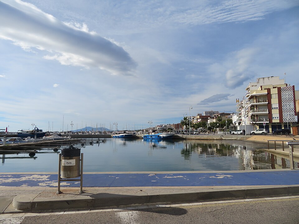
L’Ampolla is a fishing village and small resort on the northern edge of the Ebro Delta, in the Baix Ebre district of southern Catalonia, reached from the AP-7 motorway (exit 39), the N-340 or by train on the R16 line. The tourist portal of the Catalan government calls it the gateway to the Delta: it sits at the inner end of the Gulf of Sant Jordi, with rocky coves north of the port and long, shallow sand beaches to the south. From the village you can walk to the Bassa de les Olles, a 54-hectare lagoon of the Ebro Delta Natural Park. It suits families, birdwatchers, walkers and anyone who wants a quiet base for the delta; skip it if you want nightlife or big resort amenities.
Quick facts
- Names: L’Ampolla in Catalan (official); La Ampolla or Ampolla in Spanish. The name means “the bottle”, and the regional portal says it comes from the shape the river once had where it reached the sea here.
- Where: Baix Ebre district, Tarragona province, Catalonia. The coast runs from Cap Roig in the north to the Arenal beach in the south.
- Coordinates: 40.8122, 0.7070 (village centre, OpenStreetMap).
- Population: 3,785 (municipal register, 2025, as quoted by Wikipedia).
- Municipality since: 1990, when it split from El Perelló. A first decree of separation in 1937 was cancelled after the Spanish Civil War.
- From La Ràpita: about 24 km in a straight line, on the other side of the delta.
Getting there and around
By car: the AP-7 motorway has an exit for L’Ampolla (exit 39), and the N-340 coast road runs through the municipality. A local road links it with Deltebre in the delta (Spanish Wikipedia). Deltebre lies about 10 km south in a straight line, L’Ametlla de Mar about 11 km north-east and Amposta about 16 km south-west.
By train: L’Ampolla has a station on the R16 regional line, which follows the coast between Tarragona and Tortosa. Catalunya.com lists L’Ampolla, Camarles and Amposta as the train stations for the natural park.
By bus: buses run to Tortosa and L’Ametlla de Mar. The beach pages on catalunya.com name the Perelló–Tortosa line run by Autocars Carrera. Check current times with the operator.
On the spot: the centre is small enough to walk, and a bike works well for the seafront and the flat delta roads. The tourist office is on Ronda del Mar, 12, opposite the port.
Beaches and coves
North of the port: low cliffs and small coves. South of it: the delta and long, flat sand. Sizes are from catalunya.com.
- Platja de l’Arenal: the longest beach on this stretch of coast, almost 2.5 km long and about 70 m wide, fine golden sand and calm, shallow water. The page lists lifeguards, showers, portable toilets, facilities for people with reduced mobility, parking and a bar-restaurant.
- Cala de les Avellanes: about 150 m by 30 m, fine sand and a shallow bottom, just north of the port. It has ramps for reduced mobility and is busy in summer.
- Platja de Cap Roig: 190 m by 40 m of fine sand below pines and carob trees, with lifeguards, showers, toilets and a beach bar.
- Cala del Baconer: 200 m by 70 m of black and white pebbles below a cliff path, with showers. The GR 92 coastal path enters the municipality here.
- Platja dels Capellans: a small cove, 50 m by 30 m, of pale pebbles. No services apart from signs.
- Platja de l’Arquitecte: 130 m by 15 m of fine sand and small pebbles next to the marina, without services.
The Bassa de les Olles and the delta
The Bassa de les Olles is the smallest lagoon in the Ebro Delta, about 54 ha, between the Arenal beach and El Goleró, where it drains into the Fangar bay. The natural park describes it as a refuge for flamingos, mallards, great egrets, kingfishers and black-winged stilts, and as one of the old mouths of the Ebro left behind when the river moved.
The park’s walking route 10 starts at the Olles information point near the Arenal beach. It is a circular, signposted walk of 3.3 km, graded very easy, flat, about one hour, with yellow paint marks and posts. It passes a north, a central and a south hide and a raised concrete-and-wood viewpoint that takes ten people at a time. Free parking with 40 places sits next to the information point. The park’s map lists the route as partly adapted for people with reduced mobility. Bring binoculars.
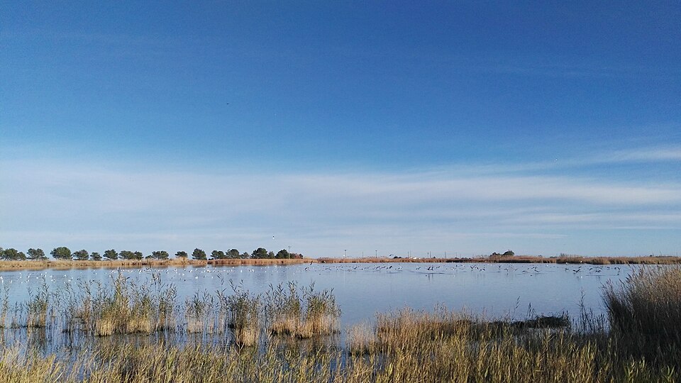
Inland, rice fields cover the south of the municipality. Walking stage 30 of the GR 92 leaves the port, follows the Arenal for a short way and then the Canal Nou de Camarles through rice fields to Camarles, L’Aldea and Amposta, 16.3 km in all. Stage 29 goes north along the coast to L’Ametlla de Mar, 15.3 km. The park map also lists boat trips on the bays leaving from La Ràpita and L’Ampolla.
The port, food and festivals
The fishing port still works: the regional portal says you can watch the daily fish auction there. The marina next to it is run by the Club Nàutic L’Ampolla, with 433 berths and courses in sailing and diving. Local dishes named by catalunya.com include fideuada, eel, rice dishes, fish stews and mussels.
- Delta Oyster Day (May): about 2,500 kg of oysters handed out to visitors, according to the regional portal.
- Festa Major: for Sant Joan, around 24 June.
- Mare de Déu del Carme (16 July): four days of festivities with bull events, including the bou embolat, fireworks and, on the last night, a procession of lit boats round the bay.
- Harvest festival (23 September): shows the old way of harvesting and processing rice.
Accessibility and safety
The Arenal and Avellanes beaches have ramps or facilities for reduced mobility, and the Olles circuit is partly adapted; the coves north of the port are reached by paths and steps and are mostly pebble. Lifeguards are listed for the Arenal and Cap Roig, but we could not confirm the 2026 season dates. The lagoon path is flat and open, with little shade, so bring water and a hat in summer.
Best time to visit
Summer is the beach season and the busiest time. For walking and birdwatching, spring and autumn are quieter and cooler; the regional portal points to the Olles lagoon for the delta’s migratory birds. Winters are mild, and most rain falls in autumn.
Nearby alternatives
- Ebro Delta, about 10 km: our main guide to the natural park, its lagoons and rice fields.
- Deltebre, about 10 km: the park’s ecomuseum and boat trips to the river mouth.
- Sant Jaume d’Enveja, about 12 km: the rice-growing village on the south bank, across the Lo Passador bridge.
- L’Ametlla de Mar, about 11 km: the next fishing town north, with rocky coves.
- La Ràpita, about 24 km: the larger town on the south side of the delta.
- Punta de la Banya and the Trabucador: the sand bar and spit at the southern tip of the delta.
Distances are in a straight line from the village centre. For the whole coast from L’Hospitalet de l’Infant to Alcanar, see our Ebro Delta and southern Costa Dorada guide.
FAQ
How do I get to L’Ampolla?
By car, take exit 39 of the AP-7 or the N-340. By train, L’Ampolla has a station on the R16 line between Tarragona and Tortosa. Buses run to Tortosa and L’Ametlla de Mar.
What are the best beaches in L’Ampolla?
For children and shallow water, the Arenal (almost 2.5 km of sand) and the small Cala de les Avellanes by the port. For small coves among rocks, Cap Roig, Baconer and Capellans north of the village.
Is L’Ampolla in the Ebro Delta?
It sits at the northern edge of it. Part of the municipality, including the Bassa de les Olles lagoon, lies within the Ebro Delta Natural Park.
Is there parking at the Bassa de les Olles?
Yes. The natural park lists a free car park with 40 places next to the Olles information point, where the 3.3 km circular walk starts.
Sources and freshness
Checked 10 November 2026 · 15 sources Show
Checked 10 November 2026. Official: Catalan tourism portal on L’Ampolla (history, port, food, festivals, transport, climate), its beach pages for l’Arenal, Cala Avellanes, Cap Roig, Baconer, Capellans and l’Arquitecte (sizes, services, access), the tourist office, GR 92 stage 30 and the Ebro Delta Natural Park. Ebro Delta Natural Park (Generalitat de Catalunya): Bassa de les Olles walking route and park map and guide. Background: Wikipedia in English (population, GR 92 stages) and Spanish (roads, history). The town hall’s own website could not be reached when we checked. Location and distances: OpenStreetMap contributors (ODbL). Photos: Wikimedia Commons, licences as credited.
This place is part of our Costa Dorada map and travel guide: Roman Tarragona, Salou and the Ebro Delta — see every town, beach and cove we have mapped on that coast.
How this page is made. CostaMap is written with an AI editorial system run by Ebizapple. This page is based on the sources listed above. Last updated 10 November 2026. Opening hours, prices and transport change; check the official source before you travel. How we work · Partner links and ads