
Portbou to Llançà walk (GR 92, Costa Brava)
Hiking trailThe Portbou to Llançà walk is stage 1 of the GR 92 coastal trail, the first stretch of the Costa Brava south of the French border: 9.81 km from Portbou over the last ridges of the Albera range to Colera and on past the beaches of Garbet, Canyelles and Grifeu to the harbour beach of Llançà. The Catalan tourist board gives 2 h 50 min, 484 m of climbing and 484 m of descent, rated for beginners and walkable all year. Both ends have a railway station, so getting back is simple. It suits walkers who want a half-day coastal stage with views; skip it on a day of strong tramuntana wind, which the official sheet says blows hard here.

Quick facts
- Names: GR 92 stage 1, Portbou–Llançà (GR 92 etapa 1, de Portbou a Llançà); the stretch from Colera to Llançà is often called the camí de ronda Colera–Llançà.
- Where: the northern Costa Brava between Portbou, Colera and Llançà (Alt Empordà, Girona), just south of the French border.
- Start coordinates: 42.4248, 3.1580 (Portbou station, from OpenStreetMap). The stage ends at the Platja del Port in Llançà, 42.3719, 3.1591.
- Distance: 9.81 km one way (catalunya.com).
- Height: +484 m / −484 m.
- Time: 2 h 50 min.
- Difficulty: beginners, on foot, according to the tourist board’s route sheet; the sheet also calls the terrain rough and the climb hard.
- Waymarking: yes, GR 92.
- Season: all year round.
- Entry: free.
Access and parking
By train: OpenStreetMap shows Portbou station at the start and Llançà station about 1 km inland from the end of the stage. Renfe’s R11 line (Barcelona-Sants–Portbou) stops at both, so you can leave a car at either end or come by train. Portbou is also served by French regional trains. We did not check timetables.
Parking in Portbou: OpenStreetMap maps several paid surface car parks near the seafront, including the municipal Aparcament la Riera, a few hundred metres from the station.
Parking in Llançà: OpenStreetMap shows a free car park and a free municipal car park (Aparcament municipal) near the Platja del Port, plus a paid car park by the beach.
Tourist offices: the route sheet lists the tourist offices of Portbou and the Port de Llançà as contacts; OpenStreetMap places both near the seafront.
What to expect
The official stage description starts in Portbou, a town known for its historic railway station, where you can visit the church of Santa Maria and the memorial to the philosopher Walter Benjamin at the gates of the cemetery. From there you look over the town and the bay of Portbou.
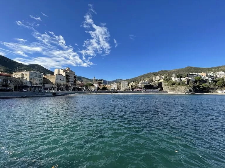
The first part is the hard one. The sheet calls the terrain rough, says the tramuntana wind blows hard and describes a tough climb across the last foothills of the Albera range and the Pyrenees, where they drop into the Mediterranean. The reward is wide views over this first stretch of the Costa Brava. After the descent to Colera, a quiet family resort, the route gets easier and passes a string of beaches, starting with the Platja de Garbet.
The path then crosses Cap de Ras and, on one of several sections of camí de ronda, reaches the Platja de Canyelles. The rest of the stage runs through built-up areas, such as the one at the Platja de Grifeu, to the Platja del Port in Llançà, where it ends.
Practical details
- What to bring: the route sheet advises suitable footwear, water and snacks, sun protection (above all in summer) and a torch in case it gets dark.
- Navigation: follow the GR 92 waymarks and carry a map; the sheet warns that your phone may fail where there is no signal.
- Swimming: the second half passes the beaches of Garbet, Canyelles and Grifeu, so bring swimwear. We found no information on lifeguards.
- Toilets: OpenStreetMap shows free public toilets by the beach in Portbou and by the tourist office at the Port de Llançà.
- Direction: the sheet describes the walk from Portbou to Llançà, which puts the hard climb at the start. Walking it the other way is possible on the same waymarks.
- Next stage: the tourist board describes stage 2, from Llançà harbour to Cadaqués.
Accessibility and safety
The tourist board rates the stage for beginners, but its own description warns of rough ground, a hard climb and strong tramuntana wind on the first section between Portbou and Colera. Check the forecast and avoid days of strong north wind on the exposed ridges. Carry water and sun protection, as the sheet advises. We could not confirm step-free access to any part of the route, so do not plan on it with a wheelchair or pushchair.
Best time to visit
The route sheet lists the stage as walkable all year round. Pick a calm day without strong tramuntana, and in summer start early so the climb out of Portbou is done before the heat, leaving the beaches for the second half.
Nearby alternatives
- Cadaqués to Roses walk (GR 92 stage 3), 18 km away (start in Cadaqués): a longer, wilder stage of the same trail on the Cap de Creus peninsula.
- Cap de Creus, 17.5 km away: the natural park on the peninsula to the south.
- Cadaqués, 18 km away: the whitewashed town on the far side of the cape.
- Cadaqués to Cap de Creus coastal walk, 18 km away: a shorter walk to the lighthouse at the tip of the cape.
- Ciutadella de Roses, 17.6 km away: the fortified citadel in Roses.
Distances are in a straight line from Portbou station.
FAQ
How long is the walk from Portbou to Llançà?
The GR 92 stage is 9.81 km one way, with 484 m of climbing. The Catalan tourist board gives 2 h 50 min of walking.
Can I take the train back from Llançà to Portbou?
Yes. OpenStreetMap shows Renfe’s R11 line stopping at both Llançà and Portbou. Llançà station is about 1 km inland from the end of the walk. Check the timetable first.
Is the Portbou to Llançà walk difficult?
It is graded for beginners, but the first part from Portbou to Colera has rough ground and a hard climb, and the tramuntana wind can blow strongly. The second half along the beaches is easier.
Can you swim along the way?
Yes. After Colera the route passes the beaches of Garbet, Canyelles and Grifeu and ends on the Platja del Port in Llançà.
Where can I park for the walk?
OpenStreetMap shows paid car parks near the seafront in Portbou and free car parks near the Platja del Port in Llançà. Many walkers can also simply arrive by train.
Sources and freshness
Checked 6 November 2026 · 2 sources Show
Checked 6 November 2026. Official: Catalan Tourist Board (catalunya.com) GR 92 stage 1, Portbou to Llançà (distance, time, height, difficulty, season, waymarking, route description, tips). Location, stations, train lines, car parks, toilets and distances: OpenStreetMap contributors (ODbL). Photos: Wikimedia Commons, licences as credited.
How this page is made. CostaMap is written with an AI editorial system run by Ebizapple. This page is based on the sources listed above. Last updated 6 November 2026. Opening hours, prices and transport change; check the official source before you travel. How we work · Partner links and ads