
Salinas de San Pedro del Pinatar (salt flats and regional park)
Natural parkThe Salinas de San Pedro del Pinatar are working salt flats and a protected wetland at the northern tip of the Mar Menor, between the lagoon and the Mediterranean, run as the Salinas y Arenales de San Pedro del Pinatar Regional Park. You reach it from the AP-7 (exit 774) or the N-332 by following Avenida del Puerto towards Lo Pagán and the port, then the signs from the Los Flamencos roundabout, where the park’s visitor centre stands. The regional tourist board gives the park 856 hectares, including 6 km of Mediterranean coast, and calls it the oldest of Murcia’s regional parks (Región de Murcia tourism). It suits birdwatchers, walkers, cyclists and anyone who wants a natural beach near a resort town; skip it if you need shade or a lively beach bar scene.
Quick facts
- Name: Parque Regional Salinas y Arenales de San Pedro del Pinatar in Spanish; in English often “San Pedro del Pinatar salt flats” or simply “Las Salinas”.
- Where: between the Mar Menor and the Mediterranean, in San Pedro del Pinatar and San Javier, Region of Murcia.
- Coordinates: 37.8133, -0.7645 (OpenStreetMap, centre of the protected area). Visitor centre: 37.8350, -0.7784.
- Size: 856 hectares, with 6 km of Mediterranean coast (Región de Murcia tourism).
- Salt: salt has been made here since Roman times; the tourist board gives a current output of 75,000 to 100,000 tonnes of sea salt a year.
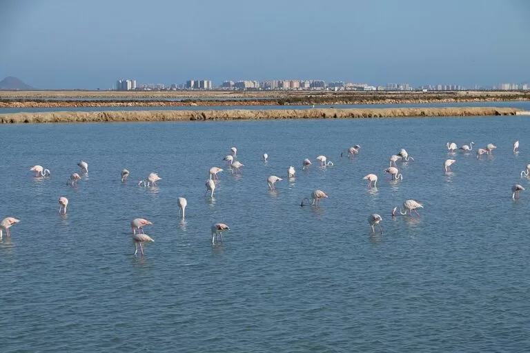
- Birds: more than one hundred species use the park, with the flamingo the best known (Región de Murcia tourism, San Pedro del Pinatar).
Access and parking
By car: leave the AP-7 at exit 774, or come along the N-332 from Cartagena, and take Avenida del Puerto towards the sea. At the Los Flamencos roundabout follow the signs for the regional park (Región de Murcia tourism, Barraca Quemada). The visitor centre at the roundabout has its own car park. For the beaches, drive on to the car park beside the port of San Pedro: Las Salinas beach, the first of the La Llana beaches, is the most visited because it is next to it, and Barraca Quemada follows just after.
We could not confirm how full the car parks get in August; arrive early in summer.
What to expect
Expect a flat, open landscape of shallow salt ponds, white salt heaps, low dunes with pines and long grey-sand beaches. The park recommends a short walk at dawn among the salt ponds, followed by a visit to the visitor centre (Región de Murcia tourism).
Birds. Flamingos, avocets and black-winged stilts can be seen all year. Black-necked grebes, great cormorants and sandpipers spend the winter here, and common and little terns arrive in spring to nest on the salt flats. The park has several bird hides along its paths.
Plants and other wildlife. Tamarisk and glasswort grow in the salt marsh, Aleppo pine and dune juniper on the older dunes. The banks of dead Posidonia seagrass on the shore are a sign of clean water, not litter. The ponds also hold the fartet, a small native killifish, and brine shrimp (Artemia).
Salt and fishing. The salt works are still in use, so many ponds are off limits. At Punta de Algas, where the Mar Menor meets the Mediterranean, fishermen still use the encañizadas, a fish trap of Arab origin made of a maze of canes and nets that catches fish moving between the two seas.
Beaches. The Mediterranean side is natural beach with dunes, protected inside the park (lengths from the tourist board’s beach pages):
- Las Salinas (La Llana) – 1,200 m of fine grey sand by the port car park; the busiest.
- Barraca Quemada (La Llana) – 700 m; a cluster of palm trees gives the only shade on the La Llana beaches.
- Punta de Algas (La Llana) – 1,260 m at the southern tip, facing the encañizadas.
- Torre Derribada – 2,210 m on the north side, with a car park, beach bars and a picnic area.
- El Mojón – 465 m on the northern edge of the park, next to the houses of El Mojón.
Walks and the visitor centre
The park has three signed paths with bird hides, information boards and two picnic areas. The best documented is the SL-MU 9 Sendero de Coterillo: 3.8 km, graded moderate by the tourist board, from the Coterillo car park with white-and-green local-path marks. It passes the Coterillo pond, the only one in the wetland not used for salt, where hides look over herons, egrets, avocets, stilts and flamingos; then runs between the salt ponds and wind-bent pines to the Torre del Coto, and returns along Torre Derribada beach on boardwalks (Región de Murcia tourism, SL-MU 9).
The Las Salinas visitor centre, on Avenida de Las Salinas by the Los Flamencos roundabout, has rooms on the Mar Menor and the park, films with English subtitles (8 and 23 minutes), free binocular loan, toilets and parking. Guided walks for the public can be requested on 968 178 139 or infosanpedro@carm.es (Región de Murcia tourism, visitor centre).
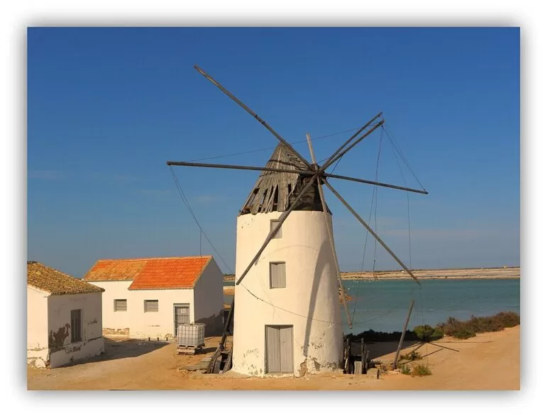
The La Mota walk. On the Mar Menor side, a dirt track along Playa de la Mota links the Quintín and La Calcetera windmills, with the salt ponds and the mud baths on one side and the lagoon on the other (Región de Murcia tourism, La Mota).
Practical details
- Visitor centre hours (checked November 2026, Región de Murcia tourism): 15 June to 15 September, Tuesday to Sunday 8:30–15:00, with Friday and Saturday also 16:00–17:30. 16 September to 14 June, Tuesday to Saturday 9:00–14:00 and 15:00–17:30, Sunday and holidays 9:00–14:00 and 14:30–15:30. Closed on Mondays.
- Price: no fee is listed for the park or the visitor centre.
- Dogs and drones: we could not confirm the park’s rules; ask at the visitor centre.
Accessibility and safety
The paths are flat but mostly sand or packed earth. Las Salinas beach has seven reserved parking spaces linked to an accessible route, and Torre Derribada has dune walkways with ramps of about 9% (tourist board accessibility notes). There is very little shade anywhere: in summer go early or late, carry water and wear a hat. Stay on the marked paths and out of the working salt ponds.
Best time to visit
Birds are present all year. Autumn and winter add the wintering waders and are the most comfortable months for walking; spring brings nesting terns; summer is hot beach season. Dawn and the last hour before sunset give the best colours on the ponds.
Nearby alternatives
- Lo Pagán mud baths – the outdoor mud pools beside the salt ponds, about 1 km west.
- San Pedro del Pinatar – the fish market and the Lo Pagán promenade, about 2 km.
- Isla Grosa – the island off La Manga, about 11 km.
- Los Alcázares – Mar Menor beaches and the old spa hotel, about 11 km.
- Isla Perdiguera – an island in the Mar Menor, about 13 km.
- Pink Lake of Torrevieja – another salt lake with flamingos, about 21 km north.
Distances are in a straight line. See also our Mar Menor north area guide.
FAQ
Can you see flamingos at San Pedro del Pinatar?
Yes. The tourist board lists the flamingo among the birds that can be seen in the park all year, together with avocets and black-winged stilts. The hides on the Coterillo path and the salt ponds by La Mota are good places to look.
Is there parking at the Salinas de San Pedro?
Yes. There is parking at the visitor centre, by the port for the La Llana beaches, at Torre Derribada beach and at the Coterillo trailhead.
Can you swim at the Salinas de San Pedro del Pinatar?
Yes, on the park’s natural Mediterranean beaches, which have few services and almost no shade. For calm, shallow water, swim on the Mar Menor side at La Mota or Villananitos.
Is the park free to visit?
The tourist board lists no entry fee for the park or the visitor centre.
Sources and freshness
Checked 6 November 2026 · 13 sources Show
Checked 6 November 2026. Región de Murcia tourism (Instituto de Turismo de la Región de Murcia): Parque Regional Salinas y Arenales de San Pedro (Spanish) and the English page, the Las Salinas visitor centre, the SL-MU 9 Sendero de Coterillo, San Pedro del Pinatar, and the beach pages for Las Salinas, Barraca Quemada, Punta de Algas, Torre Derribada, El Mojón and La Mota. Spain.info on San Pedro del Pinatar. Location and distances: OpenStreetMap contributors (ODbL). The regional environment site (murcianatural.carm.es), which hosts the park’s map and brochures, could not be reached when we checked, so the lengths of the other two paths and the rules on dogs and drones are not given.
This place is part of our Costa Cálida — the honest guide to Spain's warm coast — see every town, beach and cove we have mapped on that coast.
How this page is made. CostaMap is written with an AI editorial system run by Ebizapple. This page is based on the sources listed above. Last updated 9 November 2026. Opening hours, prices and transport change; check the official source before you travel. How we work · Partner links and ads