
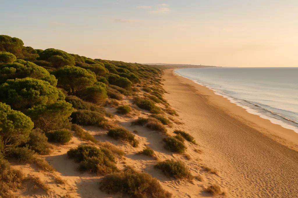
 AI-generated illustration by Ebizapple
Guardamar: Pine Dunes and Wild Beaches on the Costa Blanca
Guardamar del Segura is a beach town on the southern Costa Blanca, about 32 km (straight line) south of Alicante and 23 km from Alicante-Elche airport, at the mouth of the river Segura. Its draw is 11 km of sand backed by an 800-hectare pine forest planted from 1897 to hold back moving dunes, with a Phoenician port and a 10th-century Islamic monastery hidden in the trees. It suits beach-and-walking holidays and families; skip it if you want nightlife or a big museum scene.
Guardamar at a glance
- Where: Vega Baja del Segura (Baix Segura) district, province of Alicante, between Santa Pola (about 14 km north) and Torrevieja (about 13 km south).
- Population: 18,564 (INE 2025).
- Beaches: 11 km of coast. From north to south: El Rebollo, Els Vivers, Babilonia, Centro, La Roqueta, El Moncayo, El Camp and Les Ortigues.
- Pine forest: La Pinada, about 800 hectares, split into Parque Alfonso XIII and Parque Reina Sofía next to the town centre.
- Archaeology: La Fonteta (Phoenician port, 8th–6th century BC) and the Rábita Califal (Islamic monastery founded in 944) in the dunes about 1.4 km north of the centre.
- Language: the southernmost Valencian-speaking town; Valencian is co-official with Spanish.
- Nearest airport: Alicante-Elche, 23 km straight line.
Before you plan
No official source we checked reports any major site as closed. The Rábita and La Fonteta are open-air archaeological sites inside the pine forest; opening times are limited (OpenStreetMap lists Wednesday to Sunday, 9:00–14:00, checked November 2026), so confirm with the tourist office (Plaça de la Constitució 7, tel. 965 724 488, Monday to Saturday 9:00–14:30, closed Sundays) before you go.
Things to do in Guardamar
A visit here is about the coast, the pine forest and a cluster of archaeological sites. Most of what matters lies within 2–3 km of the town centre, so you can do it on foot or by bike.
| Attraction | What it is | Price/entry | Best for |
|---|---|---|---|
| La Fonteta | Phoenician port town at the river mouth: defensive wall, rows of houses and a street | Open-air site; check hours with the tourist office | History and archaeology |
| Rábita Califal | 10th-century Islamic monastery with 23 prayer cells, almost entirely preserved | Open-air site next to La Fonteta | Medieval and Islamic history |
| Castle hill | Ruined castle and Gothic walls above the old town, with information panels and viewpoints | Open site | Short climb, views over the Segura |
| Archaeological Museum | Finds from local digs, including the Dama de Guardamar (about 6th century BC) | OSM lists Mon–Sat 10:00–15:00 | Rainy days, context before the sites |
| Casa Museo Ingeniero Mira | House of the engineer who fixed the dunes; photos and equipment; also the tourist office | Same hours as the tourist office | Understanding the pine forest |
| La Pinada (Parque Alfonso XIII, Parque Reina Sofía) | Planted pine forest between the town and the beaches | Free | Shade, picnics, walks with children |
| Segura river mouth and Marina de las Dunas | River mouth with the Guardamar lighthouse and the Marina de las Dunas sports harbour | Free to walk | Photography, short walks |
La Fonteta and the Rábita
Both sites sit in the dunes on the right bank of the Segura, about 1 km north of the town and 1.4 km from the centre. La Fonteta was a Phoenician port dated to the 8th–6th centuries BC. The Rábita Califal was founded in 944 under Abd al-Rahman III as a coastal religious outpost; excavation began in December 1984. The regional tourist board describes it as almost entirely preserved, with 23 prayer cells. Along with the ribat of Sousse in Tunisia, it is among the oldest surviving rábitas of the western Islamic world. Both are protected Sites of Cultural Interest. The town runs guided “Sand Memories” tours that combine the castle, Parque Alfonso XIII, the Rábita and La Fonteta.
The dune forest and the shoreline
The pine forest is not natural. Pines here were cut in the 18th century to build warships, and by 1896 wind-blown sand from the Segura and the sea was burying the north of the town and its farmland. A royal order of 2 December 1897 approved a dune defence and replanting project. Forestry engineer Francisco Mira y Botella first built fences of reed and brushwood until a 4 m barrier dune formed, then planted it. Around 700 hectares were planted with some 600,000 pines, 40,000 palms and 5,000 eucalyptus. The work finished in 1929, so it took about three decades. Paths run through the trees from the town to Babilonia and Els Vivers beaches.
Castle hill and the river mouth
The upper, Moorish part of the castle was almost entirely destroyed in the 1829 earthquake. The lower walled area, where the medieval town stood until then, survives with Gothic walls altered in the 16th century. After the quake the town was rebuilt below on a grid of straight streets with low houses and wide patios, designed with earthquakes in mind. To the north, the Segura reaches the sea about 2 km from the centre. The Marina de las Dunas sports harbour is 2.3 km away and the Guardamar lighthouse about 2.9 km, both straight line. The San Antonio mill (about 1915) stands by the last weir before the river mouth.
Best beaches in the area
The beaches are long, sandy and backed by dunes or pines. Those near the centre are the busiest; the southern ones are calmer and sit next to the Moncayo dunes.
| Beach | Character | Facilities / Notes |
|---|---|---|
| Centro | Main town beach, 2,600 m | Blue Flag since 1987 according to Wikipedia; public car parks a few streets inland |
| La Roqueta | 1,180 m, just south of the centre | Blue Flag since 1987 according to Wikipedia |
| El Moncayo | 1,460 m, with dunes and a viewpoint (Mirador El Moncayo) | Blue Flag listed; car parks behind the beach on OSM |
| Babilonia and Els Vivers | North of the centre, backed by the pine forest | Closest to La Fonteta and the Rábita |
| El Rebollo | 1,360 m long, about 50 m wide, north of the river mouth | Mostly naturist |
| El Camp and Les Ortigues | Southernmost beaches, running on into Torrevieja | Quieter, fewer services |
Guardamar with kids
The pine parks next to the centre (Parque Alfonso XIII and Parque Reina Sofía) give shade a few minutes’ walk from Centro beach, which helps with small children in summer. The Fiesta del Árbol on 31 January is a tree-planting day in the forest; it has run since 1902 and was first meant for schoolchildren. Older children usually enjoy the castle panels and the Dama de Guardamar in the museum. The open-air archaeological sites have little shade at midday, so go in the morning.
How to get to Guardamar and get around
Alicante-Elche airport is 23 km away in a straight line. There is no railway station in Guardamar. The nearest stations on the Cercanías C-1 line (Alicante–Elche–Murcia) are Callosa de Segura (19.5 km) and Elche/Elx-Parc (20.5 km). The bus station (Estació d’Autobusos) is on the north side of the centre. OpenStreetMap shows bus routes from Guardamar to Torrevieja and to Orihuela, local line 1 (Guardamar Playas–Puerto) and line 2 to the urbanisations, plus long-distance coaches (Bilman Bus VAC-213, northern Spain–La Manga). Check timetables with the operators or the tourist office before you travel. In town, the centre, the pine parks, Centro beach and the castle are all within about 1 km of each other.
Parking
OpenStreetMap maps several public car parks: Parking La Redona (surface, about 140 spaces, free, near the bus station; its OSM opening hours exclude Wednesdays), the free Parking Público by Plaça Dama de Guardamar, the Ingepark car park in the centre and the El Mercat car park near the beach, both pay. There are further car parks behind El Moncayo beach. In July and August the beach streets fill early.
Where to stay in the area
Places to stay are concentrated in a few areas:
- Town centre: shops, bars, the tourist office and museums, and a short walk to Centro beach and the castle.
- Beachfront between Centro and El Moncayo: best for families who want the sand and the pine parks on the doorstep.
- Near the river mouth and marina: quieter, with walks to La Fonteta and the lighthouse.
Best time to visit Guardamar
Summer is beach season. Spring, autumn and winter suit walks in the pine forest, the archaeological sites and birdwatching at the nearby salt lagoons. The town’s main dates are the Fiesta del Árbol (31 January), Moros y Cristianos (the last two weeks of July) and the patron saint’s day (7 October).
| Season | Months | What to expect |
|---|---|---|
| Winter / shoulder season | October–May | Quieter beaches, good for walks, the castle and the archaeological sites; Fiesta del Árbol on 31 January; spring is good for birds at the Santa Pola salt flats. |
| Summer | June–September | Peak beach season; Moros y Cristianos in late July; car parks near the beaches fill early. |
History of the town
There were Phoenicians at the river mouth from the 8th century BC (La Fonteta and the walled site of Cabezo Pequeño del Estaño). The Iberian site of Cabezo Lucero is where the Dama de Guardamar was found. Muslim rulers fortified the place and founded the rábita in 944. Around 1244 the future Alfonso X took the area for Castile and founded the Christian town at the castle in about 1277. The Torrellas ruling of 1304 moved it to the Crown of Aragon and the Kingdom of Valencia. The 1829 earthquake destroyed the medieval town, and the present grid was built below the hill. The name changed from Guardamar to Guardamar del Segura in 1916. Tourism took off from the 1950s. The US Navy radio mast north of town (1962, 380 m) is the tallest structure in the European Union.
Practical info
- Tourist office: Plaça de la Constitució 7 (Casa Museo Ingeniero Mira), tel. 965 724 488, guardamar@touristinfo.net. Monday to Saturday 9:00–14:30, closed Sundays, 25 December and 1 and 6 January (regional tourist portal, checked November 2026).
- Local food: the ñora, a small dried pepper used in rice dishes, and Guardamar langoustines.
- Nearby wetlands: the Salinas de Santa Pola natural park (2,470 ha, north) and the La Mata and Torrevieja lagoons natural park, partly inside Guardamar’s own municipality, about 7 km south. Flamingos, herons and waders can be seen there.
- The town was the Valencian Region’s Capital of Culture in 2023.
Worth it for: long sandy beaches with pine shade, easy walks and real archaeology within a short walk of the town. Less so if: you want nightlife, a big resort promenade or a historic old town; the old town was destroyed in 1829 and the present centre is a 19th-century grid.
How we assess this guide
This is desk research, checked on 6 November 2026, not a site visit. History, beaches and population come from Wikipedia (English and Spanish). Sites, tours and tourist office details come from the Comunitat Valenciana tourist portal. Stations, car parks, bus routes and opening tags come from OpenStreetMap, and distances are straight-line figures worked out from OSM coordinates. Opening times change, so confirm them with the tourist office.
Frequently asked questions
How far is Guardamar from Alicante airport?
About 23 km in a straight line from Alicante-Elche airport, and about 32 km from Alicante city centre. Driving distances are longer.
Is there a train station in Guardamar?
No. The nearest stations are Callosa de Segura (19.5 km) and Elche/Elx-Parc (20.5 km), on the Cercanías C-1 Alicante–Murcia line. From Guardamar, local buses run to Torrevieja and Orihuela.
Is parking a problem?
Outside summer, rarely. OSM maps a free 140-space surface car park (La Redona) near the bus station, plus pay car parks in the centre (Ingepark, El Mercat) and car parks behind El Moncayo beach. In July and August, arrive early.
Which beach is best?
Centro and La Roqueta are the easiest, closest to cafés and car parks. El Moncayo has dunes and a viewpoint. Babilonia and Els Vivers are backed by the pine forest and close to the archaeological sites. El Rebollo, north of the river, is mostly naturist.
Can you visit the Rábita and La Fonteta?
Yes. They are open-air sites in the pine forest about 1.4 km north of the centre. OSM lists Wednesday to Sunday, 9:00–14:00 (checked November 2026), and the town runs guided “Sand Memories” tours. Confirm times with the tourist office.
Is the pine forest natural?
No. It was planted between 1897 and 1929 under engineer Francisco Mira to stop moving dunes burying the town. About 600,000 pines, 40,000 palms and 5,000 eucalyptus went in.
When is the Fiesta del Árbol?
Every 31 January. People plant trees in the pine forest, a tradition that dates from 1902 and is now backed by the town council.
Where can I see flamingos near Guardamar?
The Salinas de Santa Pola natural park to the north, and the La Mata and Torrevieja lagoons about 7 km south. The regional tourist board lists flamingos, herons and ducks at Santa Pola, and spring is a good season for terns and gulls.
Plan the wider trip
Sources and freshness
Checked 6 November 2026 · 8 sources Show
- Checked 6 November 2026. Wikipedia: Guardamar del Segura (English)
- Wikipedia: Guardamar del Segura (Spanish)
- Wikipedia: Rábita Califal de las Dunas de Guardamar
- Wikipedia: Cercanías Murcia/Alicante
- Wikipedia: Salinas de Santa Pola
- Wikipedia: Lagunas de La Mata y Torrevieja
- Comunitat Valenciana tourist portal: Guardamar del Segura, Tourist Info Guardamar, Sand Memories guided tour, Santa Pola salt flats and Guardamar dunes. Stations, bus routes, car parks, beaches and opening tags: OpenStreetMap, © OpenStreetMap contributors (ODbL)
- distances are straight-line figures worked out from OSM coordinates. The town’s own websites (guardamardelsegura.es, guardamarturismo.com) could not be reached from our research network
Nearby on the Costa Blanca
How this page is made. CostaMap is written with an AI editorial system run by Ebizapple. This page is based on the sources listed above. Last updated 6 November 2026. Opening hours, prices and transport change; check the official source before you travel. How we work · Partner links and ads