
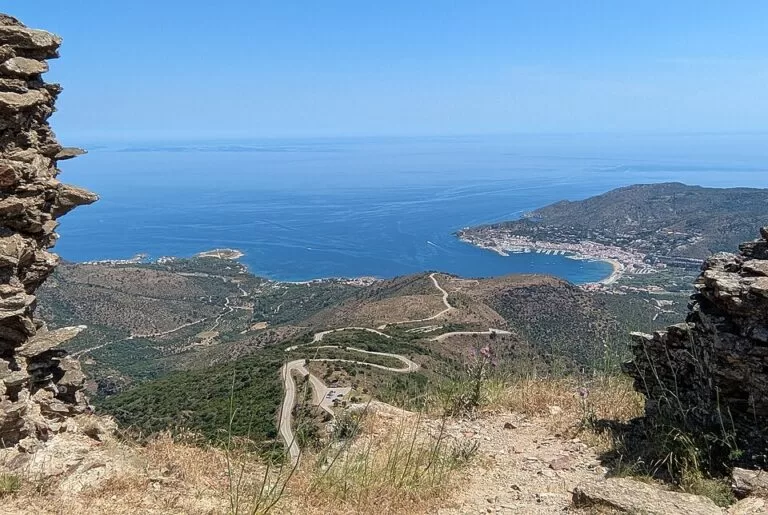
El Port de la Selva is a whitewashed fishing village on the north coast of the Cap de Creus peninsula, at the northern end of the Costa Brava, below the monastery of Sant Pere de Rodes. You reach it on the road from Llançà, or over the hills from Cadaqués, 13 km away; Moventis Sarfa buses run from Figueres. It suits families who want a sheltered town beach, walkers on the GR 92 and divers; skip it if you want nightlife or long sandy beaches.
Quick facts
- Names: El Port de la Selva (Catalan, the official name), often shortened to Port de la Selva; in Spanish, Puerto de la Selva.
- Where: Alt Empordà (Girona), on the north-west coast of the Cap de Creus peninsula, near the French border. Much of the municipality lies inside the Cap de Creus Natural Park.
- Coordinates: 42.3373, 3.2047 (village centre, OpenStreetMap).
- Population: about 780 in the village itself (OpenStreetMap).
- Beaches: the municipality has seven, of which the town beach has the Blue Flag (catalunya.com).
- Harbour: a fishing port and a marina with 328 berths for boats up to 13 m, run by the Club Nàutic Port de la Selva.
- Distances: 13 km by road to Cadaqués (Cadaqués tourist office).
Access and parking
By car: the Cadaqués tourist office describes the route from the AP-7 motorway (exit 4, Figueres–Roses, or exit 3 from France) towards Llançà and El Port de la Selva. A local road continues over the hills from the entrance of El Port de la Selva to Cadaqués, 13 km and about 20 minutes (visitcadaques.org).
Parking: the tourist board says there is a car park right next to the town beach. OpenStreetMap maps several small car parks along the seafront and near the harbour, and a free one by the viewpoint at the western entrance to the village, about 1 km from the centre. Check the signs for fees.
By bus: OpenStreetMap shows Moventis Sarfa line 30 between Figueres and El Port de la Selva, with stops at the village entrance (Mirador) and near the harbour. Figueres has the nearest main-line railway station. We did not check timetables.
On foot: stage 2 of the GR 92 coastal path runs from Llançà harbour along the shore to El Port de la Selva, and then climbs into the Cap de Creus Natural Park to reach Cadaqués on the far side of the Muntanya Negra (catalunya.com).
What to expect
The tourist board describes a white fishing village at the last foothills of the Rodes mountains, with the 18th-century church of Santa Maria de les Neus rising over the roofs and its large round window facing the sea. The name comes from the dense forests that once covered the area (catalunya.com).
It is still a working fishing port. The tourist board’s GR 92 page calls it one of the Cap de Creus villages with the strongest fishing tradition and its fishing harbour one of the most important on the Costa Brava. Anchovy, tuna and sardine are the traditional catch, and the anchovies of El Port are well known.
The village grew late. The first record is from 974, when Count Gausfred of Empúries-Rosselló gave the place to the monastery of Sant Pere de Rodes. For centuries it depended on La Selva de Mar, inland, and people kept fishing huts by the sea but did not settle until the pirate threat ended, between the second half of the 17th century and the 18th.
Beaches and coves
- Platja del Port de la Selva (El Poble or La Ribera): the town beach, 350 m long and about 40 m wide, with coarse grey sand and a very gentle slope that the tourist board calls safe for children. Showers, lifeguards, kayak hire, bars on the promenade and ramps for wheelchair users. The bay is often windy, which makes it good for windsurfing and dinghy sailing (catalunya.com).
- De Sota: a small sandy beach between the harbour breakwater and the Timba quay, in front of the town hall, much of it covered with fishing boats (catalunya.com).
- Cala Tamariua: about 1 km from the village on a paved path behind the harbour. Around 80 m of coarse sand, facing north between rock walls; no services except a small summer beach bar. The water is clear and the rocky bottom is good for snorkelling. Nudism is common (catalunya.com).
- Taballera: a wild cove reached on a 6 km footpath through the natural park. 135 m of coarse sand and flat stones; the bottom drops steeply after the first few metres. No services, few people, many boats at anchor in summer (catalunya.com).
- The other beaches are L’Erola, El Pas and Port de la Vall.
Things to do
- Sant Pere de Rodes: drive or walk up to the Romanesque monastery, the church of Santa Helena and the castle of Sant Salvador above the bay.
- Diving and boats: the tourist board lists several diving centres, boat hire and boat trips, with the marina as the hub. The Club Nàutic runs sailing, catamaran and windsurfing courses (catalunya.com).
- Cycling and climbing: more than 30 km of signposted forest tracks for cycling, plus climbing and abseiling. Paragliding flights run from the castle of Sant Salvador down to the beach.
- Walking: the path to Taballera passes the cove of Talabre, the ruined hermitage of Sant Baldiri and Mount Moro, a 148 m hill with a view over this side of the cape.
Accessibility and safety
The town beach has ramps and a car park next to it, according to the tourist board. The coves outside the village are reached only on foot or by boat, on rocky paths without shade. Strong winds often blow in the bay, the tourist board warns, above all the tramuntana; on a windy day leave the boat trip for later. Taballera shelves steeply, so keep an eye on weak swimmers.
Best time to visit
July and August are the busiest months and parking is hardest then. Spring and autumn suit walking the GR 92 and visiting Sant Pere de Rodes.
Nearby alternatives
- Monastery of Sant Pere de Rodes (3.6 km): the Romanesque abbey on the mountain above the village.
- Portbou to Llançà walk (about 5.4 km to its end at Llançà harbour): GR 92 stage 1, the stage before the one through El Port.
- Cadaqués (8 km): the best-known village of the Cap de Creus.
- Salvador Dalí House-Museum (8.3 km): Dalí’s house at Portlligat.
- Cap de Creus (9.4 km): the lighthouse at the tip of the peninsula.
- Ciutadella de Roses (8.3 km): the fortress and Greek remains of Roses.
FAQ
How do I get to El Port de la Selva?
By car from the AP-7 via Llançà, or on the 13 km hill road from Cadaqués. Without a car, take the train to Figueres, then the Moventis Sarfa line 30 bus.
Is there parking in El Port de la Selva?
Yes: next to the town beach, along the seafront and harbour, and a free one at the western entrance. In high summer they fill early.
Is the beach at El Port de la Selva good for children?
The town beach slopes very gently, has lifeguards and showers, and the tourist board calls it safe for children. The sand is coarse and grey, so bring water shoes if you prefer.
Can you walk from El Port de la Selva to Cadaqués?
Yes, on the second half of GR 92 stage 2, which climbs from El Port into the Cap de Creus Natural Park and crosses the Muntanya Negra to Cadaqués. It is a steep, exposed mountain walk.
Sources and freshness
Checked 7 November 2026 · 9 sources Show
Checked 7 November 2026. Catalan Tourist Board (catalunya.com): El Port de la Selva, the beaches of El Port de la Selva, De Sota, Cala Tamariua and Taballera, the marina and GR 92 stage 2. Road access: Cadaqués tourist office. Village centre, population, car parks, bus line and distances: OpenStreetMap. The town hall’s website could not be reached; parking fees, bus times and opening dates are not confirmed.
How this page is made. CostaMap is written with an AI editorial system run by Ebizapple. This page is based on the sources listed above. Last updated 6 November 2026. Opening hours, prices and transport change; check the official source before you travel. How we work · Partner links and ads