
Peñón del Santo (Almuñécar)
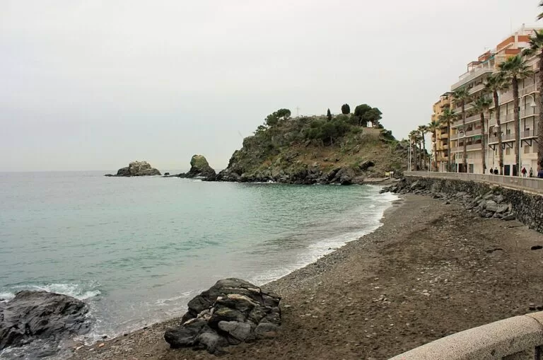
ViewpointThe Peñón del Santo is the rocky headland in the middle of Almuñécar’s seafront, on the Costa Tropical in Granada province: a rock about 30 m high that splits the town beach into Puerta del Mar to the east and San Cristóbal to the west, with a cross and a viewpoint on top. Ramps and gardens lead up from the promenade, a few minutes’ walk below the Castle of San Miguel, and entry is free. With two smaller rocks offshore it forms the Peñones de San Cristóbal Natural Monument. It suits anyone in town for a short walk and a view; it is not a half-day sight.
Quick facts
- Names: Peñón del Santo (“rock of the saint”); the group is the Monumento Natural Peñones de San Cristóbal, at the Punta de San Cristóbal.
- Where: Paseo de las Flores, 18690 Almuñécar (Granada), between Playa Puerta del Mar and Playa San Cristóbal (Andalucía.org).
- Coordinates: 36.7284, -3.6943 (summit, OpenStreetMap).
- Height: about 30 m, the largest of the three rocks (Andalucía.org); OpenStreetMap gives 28 m for the summit.
- The three rocks: Peñón del Santo on the beach, Peñón de Enmedio in the sea in front of it, and Peñón de Fuera furthest out.
- Protection: Natural Monument of Andalusia.
- Entry: free, open space; we found no opening hours.
Getting there and parking
On foot: the rock is at the end of the seafront promenade, about 300 m from the Castle of San Miguel and about 280 m from the tourist office in the Palacete de La Najarra (OpenStreetMap). From either beach you walk straight to the foot of the ramps.
By bus: OpenStreetMap shows a town bus stop called Peñón del Santo about 100 m north of the rock, on Plaza San Cristóbal. Almuñécar’s intercity bus station, on Avenida del Rey Juan Carlos I at the entrance to town, is about 1 km away.
By car: there is no parking at the rock. OpenStreetMap shows the underground Parking El Altillo, run by the town hall and charging a fee, about 500 m to the east near Puerta del Mar. Our Castle of San Miguel guide has more on parking in the old town.
What to expect
Andalucía’s tourism site calls the Peñones a natural viewpoint and a landmark of the western Granada coast, and points out that rocky outcrops like these are unusual on the Mediterranean shore. They are made of hard, dark rock that runs out into the sea “as if trying to part its waters” (Andalucía.org).
- The climb: ramps and gardens take you to the highest point, where the Cruz del Santo stands next to a viewpoint over the sea, the town and the mountains behind (Andalucía.org).
- Birds: seabirds such as the black-headed gull use the rocks.
- Under water: the submerged walls of the rocks hold colonies of orange coral (Astroides), anemones and rock fish, and shelter young fish of open-sea species (Andalucía.org).
- Abd al-Rahman I: OpenStreetMap marks a memorial to the Umayyad prince just north of the rock. Andalucía’s tourism site says he landed at Almuñécar in 755, fleeing the massacre of his family in Damascus, and founded the independent emirate of Córdoba the following year (Andalucía.org).
The two beaches. San Cristóbal, to the west, is about 1 km long with a promenade and tall buildings behind it; Puerta del Mar, to the east, is a long town beach with a good range of services. Both list lifeguards, adapted toilets and amphibious chairs (Andalucía.org, Andalucía.org). OpenStreetMap shows public toilets and showers by the rock.
What else is close
- El Majuelo: a botanical park with 182 plant species from tropical regions (Andalucía.org) around the remains of a Roman fish-salting factory that worked from the late 5th century BC to the 4th century AD (Andalucía.org), about 350 m north.
- The Castle of San Miguel: on the hill above, 300 m away.
- The aquarium: the Acuario de Almuñécar, about 500 m from San Cristóbal beach, with 3,000 animals of 270 species; the regional listing gives €12 for adults and €9 for children and over-65s, undated (Andalucía.org).
- The tourist office: in a 19th-century neo-Arab villa with a garden of cypresses and palms (Andalucía.org).
Accessibility and safety
The way up is by ramps, which helps, but the slopes are steep for wheelchairs and we could not confirm step-free access to the very top. Keep behind the railings at the viewpoint and do not climb on the rocks at the water’s edge, especially when waves break. The offshore rocks are part of a protected natural monument: do not land on them or disturb the birds.
Best time to visit
Any time of year, as part of a walk through town. Late afternoon light is good for looking west along San Cristóbal beach, and in summer the morning is cooler for the climb. Combine it with the castle and El Majuelo for a half day.
Nearby alternatives
- Castle of San Miguel, 0.3 km away: the castle on the hill above the old town.
- Marina del Este, 2.9 km away: the marina at the Punta de la Mona, by La Herradura.
- La Herradura, 3.9 km away: the beach village in the next bay west.
- Playa de Cantarriján, 7.4 km away: the naturist beach under Cerro Gordo.
- Castillo de Salobreña, 9.5 km away: the Nasrid castle above Salobreña.
- Maro–Cerro Gordo Cliffs, 9.9 km away: the protected cliffs to the west.
Distances are in a straight line from the summit. More on this stretch in our Almuñécar and La Herradura guide and the Almuñécar town guide.
FAQ
What is the Peñón del Santo in Almuñécar?
A rock about 30 m high on the seafront that divides the town beach into Puerta del Mar and San Cristóbal. With two smaller rocks offshore it forms the Peñones de San Cristóbal Natural Monument.
Can you walk up the Peñón del Santo?
Yes. Ramps and gardens lead to the top, where there is a cross and a viewpoint. Entry is free.
Is there parking near the Peñón del Santo?
Not at the rock. The nearest public car park on OpenStreetMap is the underground Parking El Altillo, run by the town hall, about 500 m east.
Which beaches are next to the Peñón del Santo?
San Cristóbal on the west side and Puerta del Mar on the east side, both urban beaches with lifeguards and adapted services.
Sources and freshness
Checked 9 November 2026 · 10 sources Show
Checked 9 November 2026. Official: Andalucía’s tourism site on the Peñones de San Cristóbal, Almuñécar, San Cristóbal beach, Puerta del Mar beach, the El Majuelo factory, El Majuelo park, the aquarium and the tourist office; spain.info on Almuñécar. Location, height, bus stop, toilets, car park and distances: OpenStreetMap contributors (ODbL). Almuñécar’s own tourism website and Turgranada could not be reached from here. Photo: Wikimedia Commons, licence as credited.
How this page is made. CostaMap is written with an AI editorial system run by Ebizapple. This page is based on the sources listed above. Last updated 9 November 2026. Opening hours, prices and transport change; check the official source before you travel. How we work · Partner links and ads