
Charca de Suárez Nature Reserve (Motril)
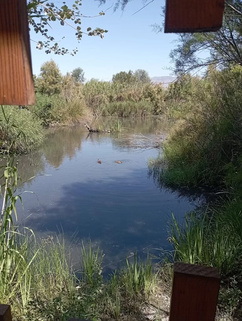
Natural parkCharca de Suárez is a small wetland nature reserve in Motril, on the Costa Tropical, set just behind Playa de Poniente about 3 km south-west of the town centre in a straight line. Andalusia’s official tourism site calls it the most important wetland on the Granada coast and one of the best places in Europe to watch birds: a little over 13 hectares of permanent lagoons, reed beds and old sugar-cane plots, with bird hides along the paths. It suits birdwatchers, families with patient children and anyone staying on Playa de Poniente or Playa Granada; skip it if you want a long walk or open countryside, because the whole reserve is a short loop between houses and fields.
Quick facts
- Names: Reserva Natural Concertada Charca de Suárez, also written Charca Suárez. Reserva natural concertada is an Andalusian protection category for areas protected by agreement with their owner.
- Where: Playa de Poniente, Motril (Granada), in the plain of the Guadalfeo river, between the beach road and the fields of the Vega.
- Coordinates: 36.7248, -3.5421 (centre of the reserve on OpenStreetMap).
- Size: a little over 13 hectares (Andalucía.org).
- What lives here: waterbirds all year, with squacco heron, flamingo and spoonbill among the wintering birds; amphibians breed here, and the reserve also shelters the chameleon.
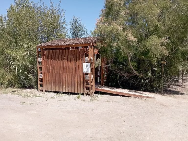
- Hides: OpenStreetMap maps seven bird hides; the named ones are called after the reserve’s animals, such as Garza Real (grey heron), Rascón (water rail), Calamón Común (western swamphen) and Galápago Leproso (Spanish pond turtle).
- Visits: from March to May, the breeding season, visits are limited to guided routes of an hour and a half (Andalucía.org).
- Run by: the reserve’s contact address on OpenStreetMap is a Motril town hall e-mail (motril.es).
Access and parking
By car: drive from Motril towards Playa de Poniente and follow the beach road west; the reserve lies inland of the promenade, a few hundred metres from the sea. OpenStreetMap shows long rows of street-side parking on the residential streets on its east side, about 250–400 m from the centre of the reserve, and small surface car parks to the south towards the beach. Several of the mapped car parks are marked private or for customers only, so use the public street spaces.
By bus: OpenStreetMap has a bus stop called “Charca de Suárez” on the Camino del Pelaíllo, at the southern edge of the reserve. Motril’s bus station is in the town (Andalucía.org lists it at Camino Nuevo de San Antonio); we could not check which urban line serves the stop or how often.
On foot or by bike: the reserve is about 0.7 km from the Poniente–El Cable stretch of beach and 0.8 km from the Playa de Poniente campsite. The campsite’s own description on Andalucía.org mentions a cycle lane that runs from the beach into town.
What to expect
The reserve is a patch of wetland that survived in the middle of Motril’s coastal plain. Groundwater rises to the surface at several points and forms lagoons that never dry out, topped up with irrigation water carried by old channels (acequias). Water from the Guadalfeo and the snowmelt of the Sierra Nevada, and an average yearly temperature above 17 °C, keep it green all year (Andalucía.org).
Andalucía.org says that in a single afternoon you can see more than ten different species of wild waterbirds. Coots, white wagtails and little grebes are there all year. In winter look for the squacco heron, flamingos and the spoonbill, which is common in Andalusia but rare in Granada province. The reserve matters for wintering, breeding and migration, and for amphibians, which is why one of the hides is named after the Mediterranean tree frog.
The plants change with the depth of the water: bur-reed and iris in the shallows, then rushes, meadows of grasses and legumes, and a few plots of the traditional crops of this coast, including sugar cane. Expect a flat walk on paths between the lagoons and the hides, with information boards along the way (OpenStreetMap maps several nature, plant and wildlife boards near the southern entrance).
Opening times and visits
We could not open the reserve’s own pages on the Motril town hall site, so check times before you go. The opening hours tagged on the reserve in OpenStreetMap (checked November 2026; not confirmed with the reserve) are:
- Weekend mornings all year: Saturday and Sunday 09:00–13:00.
- Afternoons, Wednesday to Sunday: 18:00–20:00 from June to September, 17:00–19:00 in October and February, and 16:00–18:00 from November to January.
- Closed on public holidays.
OpenStreetMap gives no hours for March to May. That fits the official rule: in the breeding season, from March to May, visits are restricted to guided itineraries of an hour and a half (Andalucía.org). We could not confirm whether entry is free, whether the guided routes must be booked, or how many people are allowed at once.
Accessibility and safety
The paths are flat, but we could not confirm step-free access to every hide or the surface of the paths. OpenStreetMap shows public toilets, some marked wheelchair accessible, along the beach road south and east of the reserve rather than inside it. Keep to the paths and keep quiet near the hides: this is a breeding site, and the guided-only rule from March to May exists to protect it. There is little shade on the beach side in summer; go early or late.
Best time to visit
Winter brings the flamingos, spoonbills and squacco herons that Andalucía.org highlights, and the cooler days make the waiting in a hide easier. Spring is the breeding season, with guided visits only. In summer the afternoon slot opens later, which is the better time to come after a day on the beach. For birds, the first and last hours of light are best, as the Salobreña birdwatching route also recommends.
Nearby alternatives
- Motril town guide, 2.9 km away: the town, its port and Playa de Poniente.
- Castillo de Salobreña, 4.7 km away: the Nasrid castle above the white town, with views over the plain where the reserve lies.
- Salobreña town guide, 4.7 km away. Salobreña also has a signed 14 km birdwatching itinerary in four stages: the cliffs of La Caleta, the mouth of the Guadalfeo, the valley of Salobreña and Lobres, and the Tajo del Gambullón (Andalucía.org).
- Torrenueva Costa, 5.6 km away: the small beach town to the east, with a 10 km cliff and viewpoint trail.
- Calahonda, 11.4 km away: the beach and diving village beyond Carchuna.
- Castle of San Miguel in Almuñécar, 13.4 km away.
Distances are in a straight line from the reserve.
FAQ
Where is the Charca de Suárez?
In Motril, behind Playa de Poniente, about 0.7 km from the beach and 3 km from the town centre in a straight line. Coordinates: 36.7248, -3.5421.
What birds can you see at Charca de Suárez?
Coots, white wagtails and little grebes all year; in winter also squacco herons, flamingos and spoonbills. Andalucía.org says more than ten species of waterbirds can be seen in one afternoon.
When is the Charca de Suárez open?
OpenStreetMap lists weekend mornings 09:00–13:00 and afternoons from Wednesday to Sunday, with times that change by month; public holidays closed. From March to May only guided visits are allowed. Check with Motril town hall before you go.
Is there parking at Charca de Suárez?
Yes, on the street. OpenStreetMap shows street-side parking on the residential streets east of the reserve, 250–400 m from its centre, and a bus stop named after the reserve on the Camino del Pelaíllo.
Can you visit with children?
Yes: it is a short, flat walk between hides. Children need to stay quiet in the hides for the birds to show.
Sources and freshness
Checked 9 November 2026 · 5 sources Show
Checked 9 November 2026. Official: Andalucía.org (Junta de Andalucía tourism) on the Charca de Suárez reserve (size, water, birds, plants, breeding-season rule), the Salobreña birdwatching itinerary, the Playa de Poniente campsite and the Motril bus station. Opening hours, hides, parking, toilets, bus stop and distances: OpenStreetMap contributors (ODbL). The Motril town hall site could not be reached when we checked, so entry price, booking and bus lines are not confirmed. Photos: Wikimedia Commons, by Thoughtfortheday (CC BY 4.0).
This place is part of our Costa Tropical, Spain: map, towns, beaches and where to stay — see every town, beach and cove we have mapped on that coast.
How this page is made. CostaMap is written with an AI editorial system run by Ebizapple. This page is based on the sources listed above. Last updated 9 November 2026. Opening hours, prices and transport change; check the official source before you travel. How we work · Partner links and ads