
Expect a mix of quiet inland streets, rugged mountains and a handful of small coastal resorts that dress up for visitors. This part of Mallorca is less about grand tourist infrastructure and more about a handful of distinctive sights—a hilltop church and castle, a string of coastal villages, and a protected islet just offshore—that reward a calm, observant visit rather than a fast-paced itinerary.
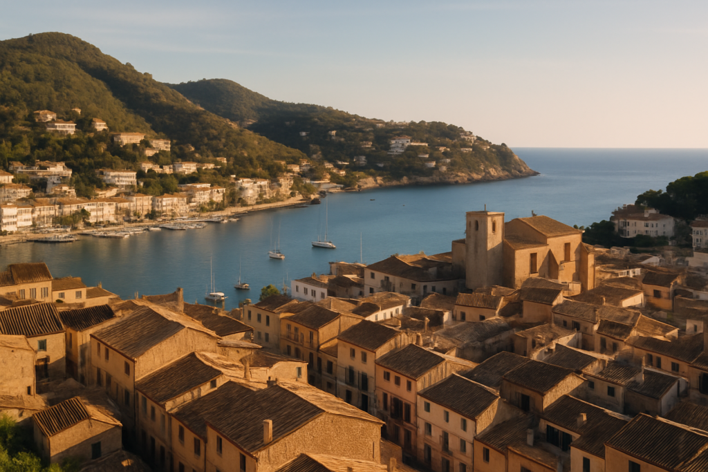
Andratx at a glance
- Located on the western tip of Mallorca in the Sierra de Tramontana.
- Municipality includes Port d’Andratx, Sant Elm, S’Arracó, Sa Coma and Camp de Mar.
- Sa Dragonera islet off the coast is a declared Natural Park (1995).
- Main economic activity today is tourism; agriculture and fishing are largely small-scale or recreational.
- Town grew inland historically because of pirate raids; important 16th‑century coastal watchtowers survive nearby.
- Highest point in the municipality reaches 927 metres above sea level.
- Southern valleys are relatively densely populated; the north is mountainous and sparsely inhabited.
Before you plan
Key historic sites and the natural park status of Sa Dragonera remain part of the area’s offer. There are no verified closures in the source material we used; if you plan to visit a specific attraction or service, check the venue’s current status before you travel because local management and opening arrangements can change.
Things to do in the area
This stretch of Mallorca suits low-key exploration: a hilltop church, a small castle, coastal villages with marinas, and a protected islet perfect for nature-minded day trips. Below is a compact comparison of the main sights backed by verified sources so you can prioritise.
| Attraction | What it is | Price/entry | Best for |
|---|---|---|---|
| Church of Santa Maria de Andrach | Historic parish church in the town | – | architecture & history |
| Castell de Son Mas | Local castle/fortified building | – | short cultural visit |
| Sa Dragonera | Islet protected as a Natural Park | – | birdwatching, nature walks |
| 16th‑century coastal observation towers | System of defensive lookout towers along the coast | – | history & coastal views |
| Port d’Andratx | Exclusive harbour resort a few miles south | – | marinas, restaurants, people-watching |
Historic centre and the church
The core town clusters inland because of a long history of pirate raids on the coastline. The town’s main church, Santa Maria de Andrach, is a focal point for visitors interested in the local built heritage and the feel of narrow streets and town squares. Nearby civic architecture and small monuments give a compact introduction to the area’s history without long walks.
Castell de Son Mas and defensive traces
Not far from the centre, Castell de Son Mas is one of the municipality’s notable monuments. Its presence is a reminder of the area’s strategic role through different eras. Complementing the castle, a regional network of observation towers erected in the 16th century still shapes the coastal silhouette; 12 of them remain within this municipality and neighbouring Calvià, making the coastline legible to anyone interested in military history and coastal defences.
Sa Dragonera Natural Park
The small islet known as Sa Dragonera was declared a Natural Park in 1995. Birdlife, rocky coves and the sense of isolation make it a worthwhile half-day trip for hikers and nature-watchers. Being a protected area, it’s valued for conservation rather than development—expect a preserved landscape rather than tourist facilities.
Best beaches in the area
There are several small coves and resort beaches scattered around the municipal coastline—Camp de Mar and Port d’Andratx are notable coastal settlements—but detailed blue‑flag status and facilities for specific beaches are not listed in our sources. If a traditional sandy beach day is a priority, check local beach information for facilities and seasonal services before you arrive.
Andratx with kids
Families who enjoy calm coastal villages, short nature walks, and manageable cultural stops will find suitable options here. Sa Dragonera’s protected landscape offers a nature focus, while the harbour at Port d’Andratx provides an easy, scenic environment for short strolls and boat-watching. The inland town centre’s compactness makes it straightforward for families to move between cafés and sights without long transfers.
How to get to the town and get around
The municipality comprises a mix of inland and coastal settlements spread along the western tip of the island and into the lower slopes of the Tramuntana range. That layout means you’ll be moving between hilltop lanes, narrow village streets and the shoreline when you explore; plan logistics accordingly.
Where to stay in Andratx
Accommodation is concentrated in a few distinct places; each suits a different visitor type.
- Port d’Andratx — the harbour resort: best for dining, marinas and a polished coastal atmosphere.
- Andratx town (inland) — quiet base: good for exploring historic streets and using the town as a hub for drives into the interior.
- Sant Elm — small coastal village: suits visitors focused on nature trips and access to offshore islands.
- Camp de Mar and Sa Coma — small resort pockets: fit for travellers who want a coastal resort feel without a large town’s bustle.
Best time to visit
The sources here don’t list local climate data or festivals, so base your timing on the kind of trip you want rather than a presumed peak season. If you value quieter lanes and natural walks, shoulder seasons tend to reduce crowds across Mallorca; if you require full coastal services and lively harbours, summer months will have the highest activity levels.
History of the town
The settlement was occupied by the Romans in the 2nd century BC under the name Andrachium, establishing an ancient lineage. The town later developed inland as a defensive measure against Barbary pirate raids, which shaped settlement patterns and local architecture. Coastal defence continued to be important into the Early Modern period: a string of observation towers was erected in the 16th century, and many of those towers survive in the landscape today. The islet of Sa Dragonera gained legal protection in 1995, reflecting more recent conservation priorities.
Practical info
- Economy and services: Tourism is the municipality’s main economic activity today, and visitor services are concentrated in the coastal resorts and the harbour area.
- Local livelihoods: Agriculture and fishing persist but are largely small-scale or for private/recreational use rather than large commercial operations.
- Topography: The municipal landscape ranges from densely inhabited southern valleys to mountainous, sparsely populated highlands; the highest point reaches 927 metres, so expect steep terrain if you venture inland.
- Settlement pattern: Because the historic town developed inland to avoid coastal raids, the historic centre sits away from the shoreline; coastal villages and the harbour are separate and reached by short drives or local connections.
- Conservation: Sa Dragonera is a declared Natural Park; visitors should respect park rules and the conservation status of the islet.
Worth it for: travellers who favour quiet historic towns, coastal villages with marinas, scenic natural areas and manageable walks. Less so if: you want a high-density beach resort or a place with extensive theme-park style attractions—this area is more subdued and nature/culture oriented.
How we assess this guide
We compiled this guide by cross-referencing verified geographic, historical and administrative facts about the municipality and its principal settlements. We flag protected sites and historic structures and note when items are conserved or date-marked. We do not invent operational details (opening times, current prices or seasonal schedules); check venues directly for up‑to‑date logistics before travelling.
Frequently asked questions
How do I get from the main transport hubs to Andratx?
Specific transfer times and services are not included in our sources. The municipality sits on the island’s western tip; the best approach is to check current public transport and private transfer options from the island’s main airport and ports when you book.
Is Andratx expensive to visit?
Tourism is the main economic activity, and one of the coastal settlements—Port d’Andratx—is described as an exclusive resort. That suggests there are higher-end options and pricing, especially around the harbour, though a range of accommodation and dining choices typically exists in such areas. For exact costs, check local listings and seasonal rates.
Which beach is the best here?
The municipality includes several coastal settlements with beaches and coves, notably in Camp de Mar and around the harbour areas. Our sources do not provide a ranked list of beaches or facility details, so for family-friendly amenities or blue‑flag status, consult local beach information before choosing.
How many days should I spend exploring the area?
It depends on your interests. A short stay of two or three days allows time for the historic centre, a stroll around Port d’Andratx and a nature visit to Sa Dragonera. Extend your trip if you plan to hike into the Tramuntana foothills or use the town as a base for exploring more of western Mallorca.
Is this area good for families?
Yes—families who prefer calm harbours, nature excursions and compact town centres will find suitable activities. Sa Dragonera offers nature-focused outings and the harbour villages provide easy walks; however, if you require large-scale children’s entertainment facilities, those are not emphasised in our source material.
Can I get around without a car?
Our sources do not list the public transport network. The municipality comprises several dispersed settlements, so having a vehicle gives more flexibility, particularly for reaching coastal villages, highland viewpoints and Sa Dragonera departure points. If you prefer not to drive, check local bus and boat timetables in advance.
Are there parking facilities in the town and at the harbour?
Specific parking details are not provided in the referenced material. As with many island towns, expect limited central parking in historic centres and more options at coastal resorts; verify parking arrangements for any hotel or harbour you plan to use.
What are good rainy-day options?
Historic buildings such as the local church and the small castle provide short, weather-proof cultural stops. Cafés and small museums in the towns often offer sheltered alternatives. For detailed indoor attractions or current events, check local tourist information.
When is the best time to visit for calm weather and quieter lanes?
While specific climatic data and festival dates are not in our sources, shoulder seasons around spring and autumn typically yield fewer crowds in Mediterranean destinations. If you prioritise quiet lanes and natural walks, those periods are usually the best bets; confirm weather expectations with a dedicated climate source before booking.
What’s special about Sa Dragonera?
Sa Dragonera is a protected islet that became a Natural Park in 1995. Its conservation status makes it important for wildlife and unspoiled coastal landscapes rather than for built tourist infrastructure.
Why is the town inland instead of on the coast?
The settlement developed inland historically as a defensive response to raids by Barbary pirates, which made coastal living precarious for long periods. That inland siting shaped the town’s layout and preserved the coastline for separate harbour settlements.
Are there historic watchtowers to see?
Yes. A system of observation towers was erected in the 16th century across Mallorca; of those, 12 survive within this municipality and neighbouring Calvià. They form part of the coastal historic landscape and are of interest to people studying military or maritime history.
Is the local economy agricultural or tourism-based?
Tourism is the main economic activity today. Agriculture and fishing still exist but are mainly on a small scale for private use or recreation rather than as dominant commercial industries.
Does the area have high terrain worth hiking?
The municipality reaches a high point of 927 metres above sea level and includes mountainous northern areas that are largely uninhabited. Those upland zones offer terrain for walkers and hikers who prefer more rugged landscapes.
How international is the local community?
Historical demographic data indicate that about 15% of the population in 2001 was foreign, with a significant number of EU nationals among them. This suggests a degree of international residency, particularly common in coastal and resort areas.
Plan the wider trip
- Palma de Mallorca city guide
- Manacor guide
- Valldemossa guide
- Sóller guide
- Ibiza old town guide
- Mahón (Menorca) guide
Andratx on the map
This place is part of our Balearic Islands Guide: Mallorca, Menorca, Ibiza & Formentera — see every town, beach and cove we have mapped on that coast.
How this page is maintained. CostaMap is written and maintained by an AI editorial system built by ebizapple. Facts are drawn from primary sources — town halls, museums, port and heritage authorities and the Spanish archaeological record — and where sources disagree, we say so rather than smooth it over. Photographs marked as ours are taken on location. This page was last reviewed on 30 July 2026. Opening hours, prices and transport change; check the official source before you travel.