
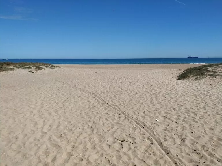
El Saler Beach (Platja del Saler) is a 2.7 km Blue Flag beach of fine golden sand inside L’Albufera Natural Park, about 11 km south of the centre of Valencia in a straight line. Get there on EMT Valencia buses 24 and 25 or by car on the CV-500, taking the Platges/El Saler exit; free car parks run behind the dunes. A line of dunes and a pine forest stand between the beach and the road, so it feels wilder than the city beaches, yet it has lifeguards, toilets, showers and accessible facilities. It suits families and swimmers who want space and nature close to the city; skip it if you want a promenade of bars and restaurants on the sand.
Quick facts
- Names: El Saler Beach; Platja del Saler in Valencian, Playa de El Saler in Spanish.
- Where: municipality of Valencia, on the sand bar between the Mediterranean and the Albufera lagoon, between Pinedo and La Devesa beaches.
- Size: 2,700 m long, 35 m wide on average (Comunitat Valenciana).
- Sand and setting: fine golden sand, natural dunes and pine forest behind.
- Awards listed by the tourist board: Blue Flag, Q for Tourist Quality and an accessible-beach certificate.
- Coordinates: 39.3826, -0.3237 (centre of the beach, OpenStreetMap).
- Distances (straight line): about 11 km from Valencia city centre, 8 km from the City of Arts and Sciences and 8 km from El Palmar.
Access and parking
By car: from Valencia take the CV-500 south towards El Saler and leave at the Platges/El Saler exit, as the regional tourist board describes. The road runs through the park on the landward side of the dunes.
Parking: OpenStreetMap shows a chain of car parks behind the dunes along the whole beach, between the sports centre in the north and the Mallada del Saler in the south; most are tagged as free. We could not confirm their capacity.
By bus: EMT Valencia lines 24 and 25 run from the city, according to the tourist board. OpenStreetMap shows stops named Platja del Saler – la Mallada, beside the toilets, and Platja del Saler – Poliesportiu at the north end. Check the EMT timetable before you go.
By bike: the tourist board says you can cycle there. To the north, L’Arbre del Gos beach has a cycle track beside the sea.
From the car park to the sand: paths and wooden walkways cross the dunes. Stay on them: the dunes are protected.
What to expect
The beach lies on the Devesa del Saler, the sand bar that separates the fresh water of the Albufera from the salt water of the Mediterranean. The tourist board’s route from Valencia to Sueca describes how it works: the mobile dunes are closest to the sea, and dense pine woods cover the fixed dunes nearer the lagoon. Spain.info puts the width of this strip at about one kilometre.
The tourist board describes El Saler as one of the most popular beaches in the Valencia area for a swim, busy in summer but calm, with a natural, wild look thanks to its dunes of great ecological value and the pine forest. The dunes shelter the beach from the wind. There are no buildings on the sand.
Between the car parks and the beach, OpenStreetMap maps picnic areas, drinking-water fountains, a viewpoint, a fitness station and information boards for several walking trails, including a landscape trail, a “senses” trail and a historical trail of El Saler. At the north end a board marks a conservation area for the Kentish plover, a small shorebird that nests on the sand. Keep out of fenced areas.
The beaches on either side
- L’Arbre del Gos, to the north between Pinedo and El Saler, is a quiet Blue Flag beach close to the first dunes, with a cycle track.
- La Garrofera, to the south between El Saler and La Devesa, has 2.5 km of sand between dunes and pines, two lifeguard stations, a beach bar and accessible facilities. The tourist board lists naturism among its services.
- La Devesa, further south, is almost five kilometres long, beside pools and malladas, the damp hollows between the dunes, with pines, palmetto, kermes oak and mastic.
- Pinedo, north of L’Arbre del Gos, is the dog-friendly beach of this coast, according to the tourist board.
Practical details
- Services listed by the tourist board: lifeguard posts, a medical point, toilets adapted for people with reduced mobility, footbaths, walkways, a taxi stop, parking and water sports. OpenStreetMap also shows showers and a public toilet block by the southern bus stop.
- Food: the tourist board lists a restaurant among the services, but there is no row of bars on the sand. Bring water and food, especially out of season. El Saler village, about 700 m inland of the beach centre, has more choice.
- Webcam: the tourist board runs a live webcam called Valencia El Saler, useful for checking the sea and crowds before you go.
- Staying nearby: OpenStreetMap shows two campsites at El Saler, and the tourist board lists Devesa Gardens, a camping resort on 80,000 m² at km 13 of the El Saler road, with bungalows and pitches.
Accessibility and safety
The tourist board lists El Saler as an accessible beach, with adapted toilets and access for people with reduced mobility; we could not confirm whether amphibious chairs or assisted bathing are offered. Lifeguards and a medical point are listed, but we could not confirm the lifeguard season, so outside summer assume no one is on duty. This is an open beach with no breakwaters: check the flag and the sea before you swim. There is little shade on the sand.
Best time to visit
June to September for swimming with services; the tourist board notes that the beach is busy in summer, so come early in the day. Outside summer the beach and the pine woods behind it make a good walk, and you can combine them with a sunset or a rice lunch in El Palmar, 8 km south.
Nearby alternatives
- Albufera Natural Park, 5 km to its map point: the lagoon, boat trips and the Racó de l’Olla visitor centre.
- El Palmar, 7.9 km: the fishing village of the Albufera, for rice dishes and boat trips.
- Oceanogràfic (València), 8.1 km: the big aquarium in the City of Arts and Sciences.
- City of Arts and Sciences, 8.5 km: the museum and architecture complex.
- La Marina de València, 8.7 km: the city’s marina beside the port.
Distances are in a straight line from the centre of the beach. For the whole stretch, see our guide to the Albufera, Sueca and Cullera.
FAQ
How do I get to El Saler Beach from Valencia?
By EMT Valencia bus 24 or 25, or by car on the CV-500, taking the Platges/El Saler exit. The beach is about 11 km from the city centre in a straight line.
Is there parking at El Saler Beach?
Yes. OpenStreetMap shows a row of car parks behind the dunes along the beach, most tagged free. Their capacity is not confirmed.
Is El Saler Beach a Blue Flag beach?
Yes, the regional tourist board lists a Blue Flag, together with a Q for Tourist Quality and an accessible-beach certificate.
How long is El Saler Beach?
2,700 m, with an average width of 35 m, according to the tourist board. La Garrofera and La Devesa continue south for several more kilometres.
Can you bring dogs to El Saler Beach?
Dogs are not listed among its services. The tourist board lists Pinedo, to the north, as the dog-friendly beach.
Sources and freshness
Checked 6 November 2026 · 10 sources Show
Checked 6 November 2026. Official: Comunitat Valenciana tourist board on El Saler beach, L’Arbre del Gos, La Garrofera, La Devesa, Pinedo, the route from Valencia to Sueca, Devesa Gardens and the rice fields (EMT buses 24 and 25); Spain.info on the Albufera. Beach position, car parks, bus stops, toilets, trails and distances: OpenStreetMap contributors (ODbL). Not confirmed: lifeguard season, car-park capacity, EMT timetables and the dog rules. Photo: Wikimedia Commons, licence as credited.
This place is part of our Costa Valenciana Map: Valencia, Gandia and the Albufera — see every town, beach and cove we have mapped on that coast.
How this page is made. CostaMap is written with an AI editorial system run by Ebizapple. This page is based on the sources listed above. Last updated 6 November 2026. Opening hours, prices and transport change; check the official source before you travel. How we work · Partner links and ads