
Playa de Valdevaqueros (Tarifa)
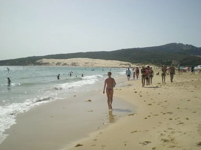
BeachPlaya de Valdevaqueros is the big kitesurfing and windsurfing bay about 10 km north-west of Tarifa (Cádiz), reached from the N-340 and backed at its western end by the large Valdevaqueros sand dune. Spain’s official tourism portal lists it at 4,050 m long and 120 m wide, with toilets, showers and water-sports rental, and Tarifa town buses stop by the campsites behind it. It is a natural beach with campsites and beach bars rather than a resort. It suits kitesurfers, windsurfers and people who like long walks on wide sand; skip it on a strong wind day if you want a calm swim or a quiet towel spot.
Quick facts
- Names: Playa de Valdevaqueros, often just Valdevaqueros (Spanish playa is beach). The dune is the Duna de Valdevaqueros.
- Where: municipality of Tarifa (Cádiz), on the Strait of Gibraltar, between Punta Paloma to the west and the Los Lances side of Tarifa to the east.
- Coordinates: 36.0681, -5.7004 (western end, by the dune).
- Size: 4,050 m long and 120 m wide (spain.info). The sand mapped on OpenStreetMap runs for about 4 km.
- Surface: golden sand.
- Water: moderate waves and windy (spain.info).
- Facilities: water-sports rental, toilets, showers, litter bins, cleaning, telephone, a sports area, a surf practice zone and a diving zone (spain.info).
- Distance to Tarifa: about 10 km in a straight line from the dune end.
- Entry: free.
Access and parking
By car: spain.info names the N-340 as the nearest road, and lists easy access on foot and by car. From Tarifa you drive north-west along the N-340 towards Cádiz; the beach lies between the road and the sea.
Parking: OpenStreetMap maps a free surface car park about 500 m from the dune end, and further car parks behind the middle of the bay, one of them a paid car park (Parking Bilbo Tarifa). We could not confirm capacity or summer prices. In peak season, arrive early.
By bus: OpenStreetMap shows stops of the Transporte Urbano de Tarifa, run by Tarifa town hall, behind the beach: Camping Jardín de las Dunas (about 700 m from the dune), Camping Paloma and Tangana – Bibo. We could not confirm the 2026 timetable or season, so check with Tarifa town hall before you rely on it.
What to expect
spain.info describes Valdevaqueros as a huge, clean beach with blue water, ideal for windsurfing. OpenStreetMap tags the beach for kitesurfing, and on a windy day the bay is full of sails and kites. Its official listing puts occupancy at high: this is one of the busiest beaches in the Tarifa area in summer.
The western end is dominated by the Duna de Valdevaqueros, a large sand dune that OpenStreetMap marks with a viewpoint. From the top you look out over the bay and the Strait of Gibraltar. Climbing the dune in soft sand is tiring, so take water and shoes that can cope with hot sand.
Behind the bay there are no apartment blocks on the beach front. OpenStreetMap shows campsites (El Jardín de las Dunas, Camping Paloma and Camping Valdevaqueros), several beach bars and restaurants, drinking water and a toilet block. The N-340 coast road runs behind the dunes.
The wind is the main thing to plan around. A strong wind that is perfect for kitesurfing makes sunbathing hard: blowing sand stings, umbrellas fly and the water can be choppy. On those days families often move to more sheltered spots.
Practical details
- Water sports: spain.info lists water-sports rental and a surf practice zone. If you are new to kitesurfing, take lessons rather than learning alone in a crowded bay.
- Diving: spain.info also lists a diving zone.
- Food: beach bars and restaurants are mapped behind the sand; we could not confirm 2026 opening dates.
- Nearest marina: Algeciras, 30 km away (spain.info).
- Shade: there is almost none on the sand. Bring a hat and plenty of water.
Accessibility and safety
Keep clear of kite lines and launch areas: kites can drag people and lines can cut. Swimmers should stay out of busy kite zones and follow the beach flags and signs. We could not confirm the 2026 lifeguard service or step-free access to the sand; access from the car parks crosses loose sand and dunes. Do not climb or slide on fenced parts of the dune.
Best time to visit
For kitesurfing and windsurfing, the wind matters more than the month: check a wind forecast before you go. For a beach day without strong wind, pick a calm day and come early in the morning. July and August are the busiest months, when parking and the campsites fill. Spring and autumn are quieter and still mild.
Nearby alternatives
- Tarifa, 10.4 km away: the town at the southern tip of Spain, with the Los Lances beach.
- Playa de Bolonia, 5.9 km away: the next big beach to the west, past Punta Paloma.
- Baelo Claudia, 7.1 km away: the Roman town ruins behind Bolonia beach.
- Playa de Zahara de los Atunes, 15.3 km away: a village beach further up the coast.
- Barbate, 24.2 km away: the fishing town known for tuna.
Distances are in a straight line from the western end of the beach.
FAQ
How far is Valdevaqueros from Tarifa?
About 10 km north-west in a straight line, reached along the N-340. Tarifa town buses stop behind the beach; check the timetable first.
Is there parking at Valdevaqueros beach?
Yes. OpenStreetMap maps a free car park about 500 m from the dune and more car parks behind the bay, one of them paid. They fill early in summer.
Can you swim at Valdevaqueros?
Yes, but it is often windy with moderate waves (spain.info), and kites and windsurfers share the water. Swim away from kite areas and follow the flags.
Is Valdevaqueros good for kitesurfing?
Yes. It is one of the main kite and windsurf beaches around Tarifa, with a surf practice zone and water-sports rental listed by spain.info.
Can you climb the Valdevaqueros dune?
The dune is at the western end of the beach, and OpenStreetMap marks a viewpoint on it. Keep to open paths and out of fenced areas.
Sources and freshness
Checked 6 November 2026 · 2 sources Show
Checked 6 November 2026. Official: spain.info, Playa de Valdevaqueros (size, sand, waves, services, road, occupancy, marina). Location, dune viewpoint, parking, bus stops, campsites and distances: OpenStreetMap contributors (ODbL). The Tarifa town hall website (tarifa.es) could not be reached from our research tools, so the bus timetable and lifeguard service could not be checked. Photos: Wikimedia Commons, licences as credited.
This place is part of our Costa de la Luz, Spain: beaches, towns, sherry and map — see every town, beach and cove we have mapped on that coast.
How this page is made. CostaMap is written with an AI editorial system run by Ebizapple. This page is based on the sources listed above. Last updated 6 November 2026. Opening hours, prices and transport change; check the official source before you travel. How we work · Partner links and ads