
Expect a low-key Costa Cálida destination where the coastline and a long history — from Paleolithic shelters to a 19th‑century mining boom — are the main draws. This is not a glossy resort strip; it’s a scattering of small towns and rugged coastline that rewards people willing to slow down, read signposts at archaeological sites and accept that infrastructure is functional rather than glam. If you want loud nightlife and guaranteed white‑sand perfection, look elsewhere; if you like bays, quiet harbors and a sense of layered history, you’ll find much to explore.
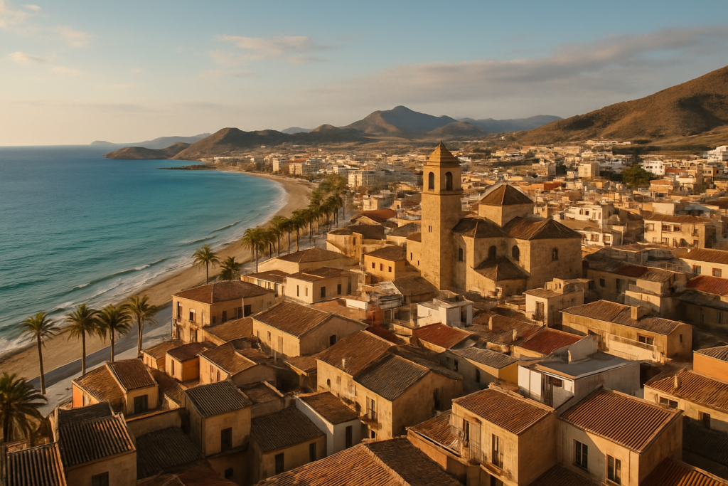
Mazarrón at a glance
- Good road access via the N-332, A7 and AP-7; regional bus services connect to nearby cities.
- Municipality made up of 13 towns and villages, including Puerto de Mazarrón and Bolnuevo.
- Sits on the Mediterranean coast with a mixed shoreline of bays and small ports.
- Main landform is the Sierra de Las Moreras running through the territory.
- Contains notable geographic features such as the Rambla de Las Moreras.
- Area: 318.7 km²; population recorded as 31,562 (2019).
- Bordered by Cartagena and Fuente Álamo (east), Alhama de Murcia and Totana (north), and Lorca (west).
Things to do in Mazarrón
The town and surrounding villages are best explored in a loose loop: a mix of archaeological excursions, short coastal walks, visits to small harbors and a look at the mining legacy that shaped the 19th century. Nothing here requires a tight schedule — plan a few half‑day trips and a couple of slower days to soak up the coast.
| Attraction | What it is | Price/entry | Best for |
|---|---|---|---|
| Permera Cave | Paleolithic archaeological site | – | history buffs, archaeology |
| Los Tollos ravine | Prehistoric ravine with archaeological relevance | – | hikers, archaeology |
| Sierra de Las Moreras | Principal mountain range in the municipality | – | walks, landscape views |
| Puerto de Mazarrón | Main harbour town within the municipality | – | sea views, seafood, boat activity |
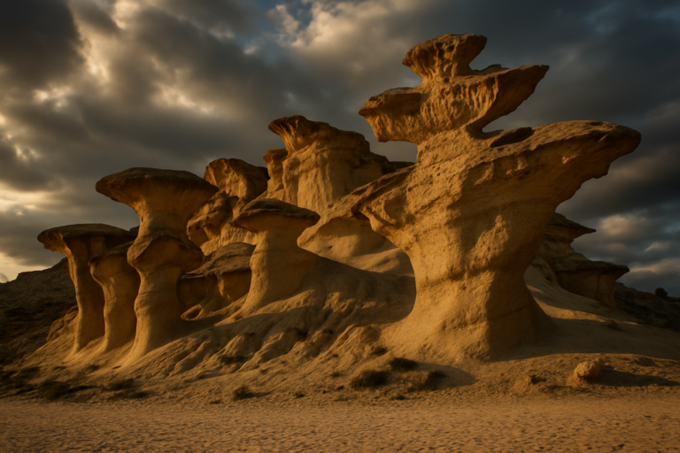
| Bolnuevo | Coastal village known locally for geological formations and beaches | – | relaxing coastal walks |
Mining heritage and industrial archaeology
The 19th century brought a mining boom that peaked in the 1840s; mining shaped settlement patterns and the local economy for decades. While industrial scale extraction has long since declined, traces remain in the landscape and in local place names. Interpreting this history will deepen your visit — look for remnants and local references rather than large museums devoted solely to mining.
Paleolithic sites and prehistory
There are genuine prehistoric remains in the area, including the Permera Cave and sites in the Los Tollos ravine. These places underline a much older human presence than coastal tourism implies; they’re of interest to anyone curious about deep time in southeastern Spain. Access and interpretation varies, so plan on modest, site‑level infrastructure rather than visitor centers unless you confirm otherwise in advance.
The coast and small harbour towns
Puerto de Mazarrón is the municipality’s main seaside centre, functioning as a working harbour and local service hub. Bolnuevo is a compact coastal village with shoreline features that attract visitors seeking quieter bays and rock formations. Expect a relaxed pace in these settlements, with local seafood and simple marina atmospheres.
Where to stay in the area
- Puerto de Mazarrón — best if you want the convenience of a harbour, local services and a central base for coastal walks.
- Bolnuevo — suits travellers after a small‑village feel and proximity to quieter shoreline spots.
- Inland villages and hamlets — choose these if you prefer rural tranquillity, proximity to hiking in the Sierra, or a homebase for exploring archaeological sites.
How to get to Mazarrón and get around
Road access is the most straightforward option: the municipality is served by major routes that run along the Costa Cálida. There are also bus services linking the area to neighbouring cities and towns; local buses are the realistic public‑transport option if you prefer not to drive. Within the municipality, taxis and local buses serve the populated centres, while reaching remote archaeological sites or mountain trails is easiest by car.
Best time to visit Mazarrón
The coast is naturally busiest in the warm months, when people come for seaside days and coastal dining. Shoulder seasons (spring and autumn) tend to offer milder conditions and fewer crowds, making them a practical choice for combining archaeological visits, walks in the sierra and short boat excursions. Winter remains mild compared with inland Spain, but expect a quieter town and reduced seasonal services.
History of Mazarrón
The area has a long human presence, evidenced by Paleolithic sites such as Permera Cave and remains in the Los Tollos ravine. In the 19th century, the municipality experienced a mining boom that reached its height in the 1840s; mining dominated local life and economy for much of that century. During the 20th century the economic base shifted away from mining toward agriculture, construction and tourism as new livelihoods took hold.
Practical info
- Health services: the municipality is part of Health Area II and has primary care centers in both the main town and the harbour (Puerto de Mazarrón).
- Economy: agriculture and fishing remain important, with about 21.9% of the territory used for crops; the coast maintains active small‑scale fishing alongside tourism.
- Landscape notes: the Rambla de Las Moreras is a notable local geographic feature that shapes drainage and some walking routes.
- Bordering municipalities affect day‑trip options: Cartagena, Fuente Álamo, Alhama de Murcia, Totana and Lorca are the closest neighbouring areas.
Worth it for: people who want a low‑key Mediterranean coast with archaeological interest, coastal villages and a visible mining past. Less so if: you want resort nightlife, guaranteed ultra‑fine beaches or a heavily curated visitor infrastructure.
How we assess this guide
This guide synthesises municipal, geographic and health‑service facts from verified records and regional sources. We cross‑checked place names, historic summaries and administrative details; we flag major changes where source data indicates closures or redevelopment. This is not original field reporting — use it as a factual planning baseline and check local timetables and site opening details before you travel.
Nearby on the Costa Cálida
Towns near Mazarrón
- Fuente Álamo de Murcia — 19 km north-east, the San Agustín church
- Totana — 25 km north-west, a gateway to the forested Sierra Espuna mountains
- Cartagena — 29 km east
- Alhama de Murcia — 30 km north, an old thermal-spa town with a hilltop castle and gateway
- Águilas — 32 km south-west
- Lorca — 35 km west, an inland Murcia town crowned by the Fortress
Places to visit within reach
- Gredas de Bolnuevo — 5 km, The Gredas de Bolnuevo are pale sandstone formations eroded by wind
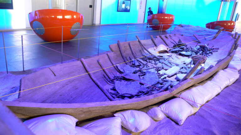
- Phoenician Shipwrecks of Mazarrón — 6 km, The Mazarrón shipwrecks yielded the earliest true anchor ever found
- Puerto de Mazarrón — 6 km, Puerto de Mazarrón is a working fishing town with sandy bays
- Cartagena Cathedral — 29 km, Cartagena Cathedral lost its own religious authority to Murcia
For the wider picture, see the Costa Cálida guide, which lists every town on this coast.
Frequently asked questions
How do I get to the area from other parts of Spain?
The simplest overland routes are by road: the N-332, A7 and AP-7 provide access along the coast and to inland connections. Regional bus services also link the municipality with nearby cities and towns.
Is it easy to travel around without a car?
Public buses serve the main towns and there are local taxi services; however, reaching scattered archaeological sites and remote coastal coves is far more convenient with a car. For a car‑free visit, stick to the main harbour town and nearby villages that are connected by bus.
Which seaside area or village has the most services?
The main harbour town functions as the service hub: it’s where you’ll find the concentration of shops, restaurants and transport links. Smaller villages have a quieter selection of amenities.
Are there beaches worth visiting?
The municipality fronts the Mediterranean and offers a variety of bays and small beaches. The coastline is mixed — from sheltered coves to more open stretches — so choose sites based on whether you want seclusion, a working harbour atmosphere or easy access to town facilities.
How many days should I plan to see the highlights?
For a relaxed visit that includes a coastal day, a short archaeological excursion and a sierra walk, plan on two to four days. Add more if you want to use the area as a base for exploring neighbouring municipalities.
Is Mazarrón expensive for eating out and services?
The area is typical of small Mediterranean coastal towns: you’ll find local seafood and simple eateries alongside basic tourist services. It’s not positioned as a high‑end resort strip, so options range from informal local restaurants to mid‑range establishments rather than luxury dining clusters.
Are there archaeological sites to visit when it’s rainy?
There are Paleolithic sites in the territory, but onsite facilities vary; some places are outdoor or semi‑sheltered and may be less comfortable in heavy rain. Check access and visitor provisions in advance if weather is a concern.
What sort of walking and hiking is available?
Short coastal walks, trails in the Sierra de Las Moreras and routes around ravines such as Los Tollos offer options for varied abilities. Trails tend to be straightforward but can be exposed; bring water and sun protection in warm months.
Is the area family‑friendly?
Yes — families who like quiet beaches, short walks and simple village life will find suitable options. There are fewer purpose‑built amusement attractions, so plan family days around the coast, gentle hikes and archaeological visits.
Where are the nearest larger cities for a day trip?
The municipality borders Cartagena and several inland towns; these neighbouring areas provide options for museums, larger shopping centres and rail connections. Use local buses or drive to reach them from the harbour town.
Can I combine this trip with other parts of the Costa Cálida?
Yes — the road network and bus links make it straightforward to link visits to other coastal destinations and inland towns in the region. It works well as part of a multi‑stop coastal itinerary.
Is there visible mining history to see?
Mining activity peaked in the 19th century and left traces in the landscape and local memory. Visitors can observe industrial archaeology in scattered sites and learn about the historical shift from mining to agriculture, construction and tourism during the 20th century.
What healthcare services are available for visitors?
The municipality is included in Health Area II and has primary care centres located in the main town and the harbour town, providing basic healthcare access for residents and visitors.
Are there distinctive natural features worth photographing?
Yes: coastal rock formations, the Rambla de Las Moreras and the ridgelines of the Sierra de Las Moreras create varied landscapes for photography, from shoreline textures to rugged inland panoramas.
Is it crowded in peak season?
The town and coastal villages see increased visitors in the warm months, but the area tends to remain quieter than large resort centres — expect more local traffic and seasonal services rather than overwhelming crowds.
Plan the wider trip
Mazarrón on the map
Places worth knowing near Mazarrón

How this page is maintained. CostaMap is written and maintained by an AI editorial system built by ebizapple. Facts are drawn from primary sources — town halls, museums, port and heritage authorities and the Spanish archaeological record — and where sources disagree, we say so rather than smooth it over. Photographs marked as ours are taken on location. This page was last reviewed on 11 August 2026. Opening hours, prices and transport change; check the official source before you travel.