
El Palmar (Albufera, Valencia)
VillageEl Palmar is a small fishing village on an island of rice fields inside L’Albufera Natural Park, about 18 km south of the centre of Valencia in a straight line. You reach it by car on the CV-500 coast road or on the city’s EMT buses 24 and 25, and come for three things: a boat trip on the lagoon, a rice dish or eel stew at lunch, and the sunset from the jetty. Comunitat Valenciana, the regional tourist board, calls it the home of paella. It suits food lovers, birdwatchers and anyone who wants a half day out of the city; skip it if you want a beach, which is 5 km away at El Perelló or 8 km away at El Saler.
Quick facts
- Names: El Palmar (Spanish and Valencian), often searched as El Palmar Albufera or El Palmar Valencia. Do not confuse it with Playa El Palmar in Cádiz.
- What: a fishing village of the city of Valencia, inside L’Albufera Natural Park.
- Population: 759 (2025), as recorded in OpenStreetMap.
- Coordinates: 39.3116, -0.3177 (village centre, OpenStreetMap).
- Getting there: CV-500 by car; EMT Valencia buses 24 and 25 from the city.
- Known for: paella, all i pebre (eel and potato stew), boat trips on the lake and sunsets from the jetty.
- Park information: Racó de l’Olla interpretation centre, Carretera del Palmar, phone 96 386 80 50.
Access and parking
By car: from Valencia follow the CV-500 south through El Saler. The road crosses the park. The village sits on a side road west of the CV-500. Straight-line distances: about 18 km from the city centre, 8 km from El Saler beach and 5 km from El Perelló.
Parking: OpenStreetMap shows several small car parks around the village. Some are tagged as free, one at the north end is tagged as paid, and some restaurants have their own. We could not confirm their size or charges.
By bus: the regional tourist board says EMT Valencia lines 24 and 25 take you into the heart of the park, to Pinedo, El Saler and El Palmar. Stops in the village include “el Palmar” in the centre and “Albufera – Pl. de la Sequiota” by the church (OpenStreetMap). Check the EMT timetable before you go.
By bike: the park is flat. The tourist board calls it an easy ride with no hills.
What to expect
El Palmar is small: a few streets along the canals, the parish church of the Niño Jesús del Huerto, a row of restaurants and the jetties where the boats tie up. It is surrounded by rice fields and water on every side.
Barracas
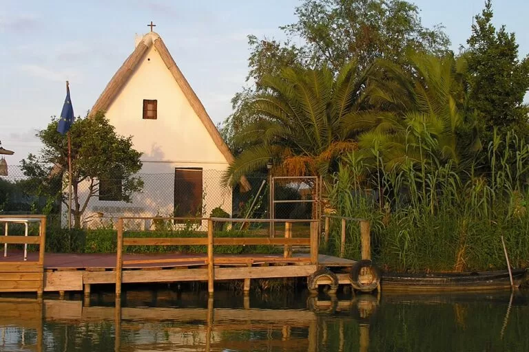
The tourist board recommends starting with the barracas, traditional houses built of wattle and daub. Spain.info describes the barraca as the typical dwelling of this part of Valencia, with a steep gabled roof of reeds and mud. OpenStreetMap marks one in the centre of the village, the Barraca de les Arandes.
Boat trips
Traditional boats, and lateen-sail boats, take visitors out through the canals onto the lake. The main jetty, the Embarcador del Palmar, is on the west side of the village (OpenStreetMap). Most trips are short; for the details, see our Albufera Natural Park guide. One example of a longer outing listed by the tourist board: a two-hour visit run by Albufera Valencia, with an hour in the rice fields learning about fishing, hunting and rice from a local fisherman and an hour by boat on the lake, for €13 per person, minimum eight people, all year, times on request (checked November 2026, Comunitat Valenciana).
Food
Lunch is the main event. The tourist board calls El Palmar the home of paella and also points to all i pebre, a stew of eel and potato, and espardenyà, a lesser-known, century-old dish similar to all i pebre. The rice grown here comes under the Arroz de Valencia Designation of Origin; the best-known varieties are bomba, senia and albufera. OpenStreetMap lists more than a dozen restaurants in the village, most of them on the main street. We do not recommend individual restaurants.
Sunset and birds
The tourist board suggests keeping the jetty for the end of the day, to watch the sunset over the water. The park has more than 350 bird species according to the tourist board (Spain.info gives nearly 300 identified species), and in the rice fields you may see greater flamingos, purple herons and glossy ibises. Bring binoculars.
Practical details
- Facilities: OpenStreetMap shows a pharmacy, a small district council office, drinking-water fountains, a playground and bike racks in the village.
- Tourist information: for the park, the Racó de l’Olla interpretation centre on the Carretera del Palmar (96 386 80 50, raco_olla@gva.es).
- Festival: the Romeria del Santíssim Crist de la Salut, a festival of Provincial Tourist Interest, carries the statue of Christ out onto the lake to bless the waters for good fishing and crops. The tourist board lists the next one for 4 August 2027.
Accessibility and safety
The village streets are flat, but boarding the boats means stepping down from a jetty into a low boat; we could not confirm adapted boats. There is little shade in the rice fields, so bring sun protection if you walk or cycle, and take care on the CV-500, the main road through the park.
Best time to visit
The rice fields change through the year, according to the tourist board: the fields are worked in January and February, flooded for sowing in May, deep green in summer and golden before the September harvest. In November and December they are flooded again, the perellonà, and become a sheet of water. Late afternoon is the best time of day for the sunset.
Nearby alternatives
- Albufera Natural Park, 2.9 km to its map point: the lagoon, the Devesa and the Racó de l’Olla visitor centre.
- El Saler Beach, 7.9 km: Blue Flag sand backed by dunes and pine woods.
- Aquopolis Cullera, 15 km: a summer water park.
- Oceanogràfic (València), 15.9 km: the big aquarium in the city.
- Cullera, 17.6 km: castle hill, lighthouse and town beaches.
Distances are in a straight line from the village centre. For the whole stretch of coast, see our guide to the Albufera, Sueca and Cullera.
FAQ
How do I get to El Palmar from Valencia?
By car on the CV-500 south through El Saler, about 18 km in a straight line from the centre, or on EMT Valencia bus 24 or 25, which the tourist board says reach El Palmar.
Is El Palmar the birthplace of paella?
The regional tourist board calls El Palmar the home of paella, and Spain.info says paella valenciana originates in the Albufera, using rice grown there.
Do you need to book a boat trip in El Palmar?
Our Albufera guide covers the short trips from the jetties, which do not need booking according to the sources we used there. Longer guided outings, such as the two-hour fishing and rice tour listed by the tourist board, must be booked and need a minimum group size.
Is there parking in El Palmar?
Yes. OpenStreetMap shows several small car parks, some tagged free and one paid; we could not confirm their size.
What is the best time to visit El Palmar?
Late afternoon for the sunset from the jetty. For the landscape, May to September for green and golden rice fields, or November and December when the fields are flooded.
Sources and freshness
Checked 6 November 2026 · 7 sources Show
Checked 6 November 2026. Official: Comunitat Valenciana tourist board on El Palmar, L’Albufera Natural Park, the rice fields (seasons, birds, rice varieties, EMT buses 24 and 25), the boat trip and El Palmar visit and the Romeria of the Cristo de la Salud; Spain.info on the Albufera (barracas, birds, paella). Village centre, population, jetty, bus stops, car parks and distances: OpenStreetMap contributors (ODbL). Not confirmed: EMT timetables, standard boat-trip prices and durations at the jetty, and boat accessibility. Photo: Wikimedia Commons, licence as credited.
This place is part of our Costa Valenciana Map: Valencia, Gandia and the Albufera — see every town, beach and cove we have mapped on that coast.
How this page is made. CostaMap is written with an AI editorial system run by Ebizapple. This page is based on the sources listed above. Last updated 6 November 2026. Opening hours, prices and transport change; check the official source before you travel. How we work · Partner links and ads