
San Vicente de la Barquera
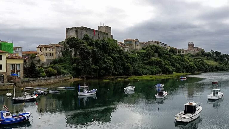
TownSan Vicente de la Barquera is a fishing town on the western coast of Cantabria, 58 km west of Santander, where two estuaries meet the sea below a castle and a Gothic church. It lies just off the A-8 motorway and the N-634, and makes a base for the Merón and Oyambre beaches and the Oyambre Natural Park. It suits people who want a working harbour town with a short old quarter, seafood and big beaches nearby; skip it if you want nightlife or a quiet beach in August.
Quick facts
- Names: San Vicente de la Barquera; locals are called barquereños or evencianos.
- Where: western coast of Cantabria, between Val de San Vicente (towards Asturias) and Valdáliga and Comillas to the east.
- Coordinates: 43.3832, -4.4003.
- Municipality: 41.5 km² and 3,995 inhabitants (INE 2025), spread over nine villages (Wikipedia).
- Protected status: the old town (Puebla Vieja) was declared of Cultural Interest in 1987 (Spain.info).
- Natural park: most of the municipality lies inside the Oyambre Natural Park, protected since 1988.
- Tourist office: Avenida de los Soportales 20, tel. +34 942 710 797 (Spain.info).
Access and parking
By car: the A-8 (Autovía del Cantábrico) and the N-634 both cross the municipality, and the CA-131 runs east along the coast to Comillas (Wikipedia).
By bus: the town has a bus station with routes across northern Spain; the companies named are ALSA, La Cantábrica and Palomera. We could not confirm timetables.
By train: the nearest station is at La Acebosa, inside the municipality, on the FEVE narrow-gauge line between Santander and Oviedo. It is outside the town, so plan on a taxi or a walk to the centre.
By air: Santander airport is about 60 km away; Bilbao and Asturias airports are both about 160 km.
Parking: we could not confirm official car parks or charges. In summer, arrive early: the beach spain.info lists closest to town, El Rosal, has a high occupancy rating.
What to see
The town grew around the castle on its rock. Alfonso VIII of Castile gave San Vicente its town charter on 3 April 1210, the last of the four “Villas de la Costa” after Castro Urdiales, Santander and Laredo, and sea trade and fishing rights made it rich in the Middle Ages (Wikipedia).
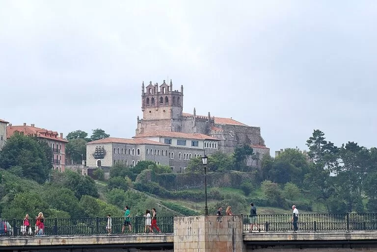
- Santa María de los Ángeles church: a Gothic church begun in the 13th century and built over more than a century, with three naves, a tower and two Romanesque doors. Inside, the tomb of the Inquisitor Antonio del Corro is the main sight (Spain.info).
- The castle (Castillo del Rey): it closes the town wall on a rocky rise. The present walls date from the 13th century onwards; it was restored in the 1990s and is used as a museum and exhibition space (Wikipedia). We could not confirm current opening hours.
- Puebla Vieja: remains of the wall and gates, the ruins of the Corro house, the Concepción hospital and the Preboste tower.
- The bridges: the Maza bridge, with 28 arches, was built on the orders of the Catholic Monarchs in the 16th century; the Parral bridge dates from the 18th century (Spain.info).
Beaches
Spain.info lists Fuentes, Primera de San Vicente, El Rosal, El Tostadero, Merón and Gerra as the town’s beaches. The figures below are from its beach pages.
- El Rosal: 180 m of golden sand on the bay, the closest beach to town, reached over the estuary bridge. Three toilets (one adapted), a ramp to the sand, showers, sun lounger and water craft rental (Spain.info).
- Merón: 2,500 m of white sand east of town, rated strong waves and windy, with toilets, showers, sunshade and lounger rental, sports and children’s play areas (Spain.info). Wikipedia describes it as over 3 km and split into El Puntal, El Rosal, Merón, Bederna and Peñas Negras.
- La Fuente: a 150 m cove of pebbles and sand near Santillán, rated strong waves, low occupancy (Spain.info).
- Oyambre: 1,800 m of sand just east, inside the natural park; see our Playa de Oyambre guide.
Oyambre Natural Park
The park covers 5,738 hectares across Comillas, San Vicente de la Barquera, Udías, Valdáliga and Val de San Vicente. Spain.info describes cliffs of 10 to 50 metres, open beaches such as Merón and Oyambre, the San Vicente and La Rabia estuaries, marshes and dunes, with peregrine falcons on the cliffs and migratory birds in the marshes. The interpretation centre is in the Punta de la Silla lighthouse, Carretera del Faro, tel. +34 942 712 019 (Spain.info).
Food and festivals
The local dish is sorropotún, a hotpot of tuna and potatoes (Spain.info). The best-known festival is La Folía, a Festival of National Tourist Interest, usually on the second Sunday after Easter. The Certamen de la Canción Marinera, a choral contest, falls on the first or second weekend of July, and on 8–9 September the town hands out sorropotún on the beach for La Barquera and El Mozucu (Wikipedia). Check dates locally each year.
Accessibility and safety
El Rosal has an adapted toilet and a ramp down to the sand. The old town and the castle sit on a hill with steep streets. Merón and La Fuente are rated strong waves: swim only where lifeguards are posted and respect the flags. We could not confirm lifeguard dates for 2026.
Best time to visit
June and September give long days with fewer people than July and August, when the beaches by town are busy. Spain.info gives a typical maximum of 20 °C. Spring brings La Folía; clear winter days give the best view of the snow on the Picos de Europa.
Nearby alternatives
- Playa de Oyambre, 5.8 km: the big beach of the natural park.
- Comillas, 8.7 km: Gaudí’s El Capricho and the Sobrellano Palace.
- HolaCamp La Franca, 14.2 km: a campsite just over the Asturian border.
- Altamira, 22.5 km: the cave art museum.
- Santillana del Mar, 23.8 km: the medieval village.
- Llanes, 28.9 km: the nearest large town in eastern Asturias.
Distances are in a straight line from the town centre. For the whole stretch, see our San Vicente de la Barquera to Suances guide.
FAQ
How do I get to San Vicente de la Barquera?
By car on the A-8 or N-634, 58 km west of Santander. Buses (ALSA, La Cantábrica, Palomera) stop at the town bus station, and the FEVE Santander–Oviedo line stops at La Acebosa, outside the town.
What is the best beach in San Vicente de la Barquera?
Merón is the big one: 2,500 m of sand with full services but strong waves. El Rosal is the closest to town, small and on the calmer bay.
What is there to see in San Vicente de la Barquera?
The Gothic church of Santa María de los Ángeles, the castle, the old town walls, the 28-arch Maza bridge and the estuary with the Picos de Europa behind.
Is San Vicente de la Barquera on the Camino de Santiago?
The town is part of the Ruta Lebaniega, the route that links the coastal Camino de Santiago with the French Way via Liébana.
What food is San Vicente de la Barquera known for?
Fish and seafood, and above all sorropotún, a tuna and potato stew.
Sources and freshness
Checked 9 November 2026 · 12 sources Show
Checked 9 November 2026. Official: Spain.info on San Vicente de la Barquera, the church of Santa María, the Oyambre Natural Park, the tourist office and the beaches of El Rosal, Merón, La Fuente and Oyambre. Background (history, transport, festivals): Wikipedia on San Vicente de la Barquera, its castle and the Oyambre park. Coordinates and distances: OpenStreetMap. The town’s own website and the Cantabria tourist board could not be reached from our research tools. Not confirmed: castle opening hours, bus and train times, parking charges and 2026 lifeguard dates.
How this page is made. CostaMap is written with an AI editorial system run by Ebizapple. This page is based on the sources listed above. Last updated 9 November 2026. Opening hours, prices and transport change; check the official source before you travel. How we work · Partner links and ads