
Expect an understated stretch of east‑Mallorca coastline and quiet inland villages rather than a single showpiece town. This is a place where long sandy beaches sit beside low-lying headlands and agricultural lanes; the resort clusters are linear along the shore and the historic centre lies inland. That arrangement shapes travel logistics, noise levels and what’s actually worth doing here.
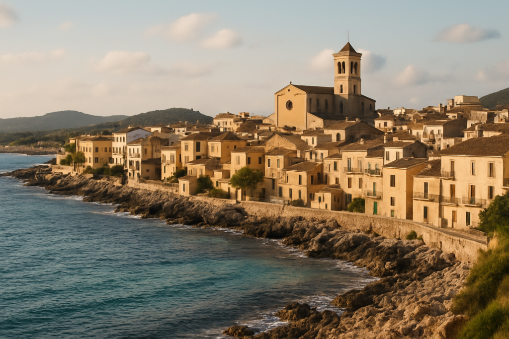
Sant Llorenç des Cardassar at a glance
- Small municipality on Mallorca’s east coast with beaches such as Sa Coma, the northern part of s’Illot and the southern part of Cala Millor.
- Punta de n’Amer is a coastal headland with a 17th‑century castle that separates Cala Millor and Sa Coma.
- The town centre is inland; Son Carrió is a village inside the municipality.
- Road links: Ma‑4023 and Ma‑4030 run along/into the coastal area; the Ma‑15 bypasses the town and continues north to Artà.
- Located about 55 km (34 mi) east of Palma de Mallorca.
- On the outskirts of the municipality the ITV2 series Love Island is filmed.
- The municipality suffered deadly flash floods on the night of 9 October 2018; the event shaped local flood‑risk planning afterwards.
Things to do in Sant Llorenç des Cardassar
The main draw is the coastal strip: beaches, promenades and the low headland at Punta de n’Amer with its small castle. Inland, the town and villages are calmer and worth visiting if you want to escape the busy seafront. Below is a quick comparison of the top sights to decide what fits your plans.
| Attraction | What it is | Price/entry | Best for |
|---|---|---|---|
| Punta de n’Amer Castle | 17th‑century coastal fortification on the headland | – | walks, coastal views, history interest |
| Punta de n’Amer headland | promontory that separates Cala Millor and Sa Coma beaches | – | short hikes, beach access, photography |
| Sa Coma / Cala Millor / s’Illot coastline | continuous seaside resort strip with long sandy beaches | – | sunbathing, family beach days, promenades |
| Sant Llorenç town centre & Son Carrió | inland municipal centre and village | – | local life, quieter evenings away from the seafront |
Punta de n’Amer and its castle
The headland is the geographical pivot of the coastal area here: it literally separates two of the main beaches. There is a 17th‑century castle on the headland — a modest military building by the coast — and the promontory is the obvious place for short walks and views back along the shoreline. If you want a break from the strip, this is the nearest natural escape.
The resort strip: Sa Coma, Cala Millor and s’Illot
The populated coastline combines several resort names into one continuous beach experience. Sa Coma occupies one side of the headland while Cala Millor and s’Illot take up the neighbouring stretches; the headland divides the two main beaches. Walking the promenade lets you move between them without a car.
Inland: the town centre and Son Carrió
The municipal centre sits away from the sea; Son Carrió is one of the villages contained in the municipality. Expect a different, quieter pace here compared with the resort fringe — more local streets and fewer tourist amenities. The town’s inland position also explains the tight network of roads that skirt and join the coast.
Best beaches in Sant Llorenç des Cardassar
The coastline is the main attraction: long, sandy beaches and a promenade that follows them. The headland at Punta de n’Amer creates two distinct beach faces.
| Beach | Character | Facilities / Notes |
|---|---|---|
| Sa Coma | Sandy beach on one side of Punta de n’Amer | Part of the municipality’s coastal area |
| Cala Millor (southern part) | Long sandy beach on the other side of the headland | Coastal resort area; southern section lies in this municipality |
| s’Illot (northern part) | Small coastal sector within the municipality | Northern part of s’Illot belongs to this area |
Sant Llorenç des Cardassar with kids
Families who prioritise accessible, long sandy beaches and promenades will find the coastal strip suitable. The headland provides short safe walks and interesting sights without strenuous hiking. The inland town and villages offer quieter accommodation options if you prefer evenings away from resort activity. Note that large TV productions film on the outskirts, which can affect local traffic and occasional noise levels.
How to get to the area and get around
The closest major hub is Palma de Mallorca: the municipality lies roughly 55 km (34 mi) east of the island’s capital. Road connections are the practical backbone of local travel: the Ma‑15 functions as a bypass around the town and continues north through Artà, while the Ma‑4023 and Ma‑4030 link the coastal settlements and neighbouring Son Servera. If you plan to explore neighbouring municipalities — Manacor, Petra, Artà and Son Servera all adjoin this area — a car or local bus that uses the main roads makes travel straightforward. The inland town centre and outlying villages are not on the immediate seafront, so check where you’re staying in relation to the coast.
Where to stay in the resort
Accommodation clusters follow two patterns: the seaside resorts along the coast and quieter inland villages.
- Seafront (Sa Coma, Cala Millor, s’Illot): best for beach access, promenades and the usual resort conveniences.
- Inland town centre and Son Carrió: better for a quieter stay and a more local feel; expect to travel a short distance to reach the beach.
Best time to visit
There’s no single microclimate claim in the record, but the place is typical of Mallorca’s Mediterranean pattern: beach activity dominates the warmer months and the headland offers shoulder‑season walks. Note the serious flash floods on 9 October 2018 — if you’re travelling in autumn, be aware that heavy rains can occasionally cause rapid changes in local conditions.
History of the town
The headland’s defensive structure dates to the 17th century, when coastal fortifications were common around the Balearics. The municipality was historically part of neighbouring Manacor until it became a separate municipality in 1892. Those facts explain why the town centre sits inland and why the coastline evolved later as a line of resort development rather than a single old harbour town.
Practical info
- Roads: Ma‑15 is a main bypass that passes north through Artà; Ma‑4023 runs parallel to the coast between Son Servera and Porto Cristo; Ma‑4030 links the town with Son Servera to the east.
- Geography: the populated seafront includes Sa Coma, the northern part of s’Illot and the southern part of Cala Millor; Punta de n’Amer is the separating headland.
- Safety history: the municipality experienced deadly flash floods on 9 October 2018 — the event is part of the recent local context for emergency planning and flood awareness.
- Culture and visibility: the ITV2 series Love Island films on the outskirts of the municipality, which brings occasional media attention and activity to nearby areas.
- Notable people: Margarita Fullana, Olympic bronze medallist (2000), was born here.
Worth it for: straightforward beach days, promenade walks and short headland hikes with a historical fortification to explore. Less so if: you expect a compact, historic harbour town or a nightlife hub — the main centre is inland and the coastal strip is organized as resort bays rather than an old town core.
How we assess this guide
We compiled this guide from verified municipal, geographic and historical sources. Road numbers, coastal divisions and historical dates are drawn from authoritative records; we flag significant events such as the October 2018 floods and note media production activity in the area. We cross‑checked municipal boundaries and place names against official references. This is an editorial synthesis rather than original on‑the‑ground reporting.
Frequently asked questions
How far is the area from Palma de Mallorca?
The municipality lies about 55 km (34 mi) east of Palma de Mallorca.
Which beach should I pick for a family day?
Choose Sa Coma or the stretches of Cala Millor — the coastal strip provides long sandy beaches and promenades suited to family visits; Punta de n’Amer offers short walks away from the sand.
Is there a historic site to visit?
Yes — the 17th‑century castle on Punta de n’Amer is the principal historical structure on the headland.
Are there quieter places to stay away from the seafront?
Yes. The town centre is inland and villages such as Son Carrió offer a quieter, more local stay compared with the seafront resorts.
What roads serve the resort strip?
The main routes are the Ma‑4023 (running parallel to the coast between Son Servera and Porto Cristo), the Ma‑4030 (connecting the town with Son Servera to the east) and the Ma‑15 which bypasses the town and heads north to Artà.
Does a TV show film here?
Yes. The ITV2 series Love Island is filmed on the outskirts of the municipality.
Are there any serious weather-related incidents in recent history?
On the night of 9 October 2018, the municipality suffered flash floods in which 13 people died. The event is a significant part of recent local history and local emergency planning.
Was the municipality always independent?
No. It was part of the municipality of Manacor until 1892, when it became a separate municipality.
Who is a famous person from here?
Margarita Fullana, who won an Olympic bronze medal in 2000, was born in the municipality.
Which neighbouring towns are easiest to reach?
The municipality adjoins Manacor, Petra, Artà and Son Servera — these are the nearest neighbouring municipalities by road.
How many days should I plan for a visit?
That depends on your priorities: short stays work if you want beach time and a headland walk; longer stays suit visitors who also want to explore neighbouring municipalities and quieter inland villages.
Is it a good destination without a car?
Public transport and local services can connect the seafront and town, but the area’s road network and the dispersed layout of coast vs. inland centre mean a car gives more flexibility for exploring neighbouring towns and reaching quieter villages.
Is parking available near the beaches?
Specific parking details aren’t listed here; the coastal resorts and promenades are typically set up for tourist access, and the road network (Ma‑4023, Ma‑4030, Ma‑15) provides the main vehicular approaches.
What can I do on a rainy day?
The record here focuses on outdoor sights; inland village life and neighbouring towns can offer quieter indoor options, but check local opening notices ahead of time for museums or scheduled events in nearby municipalities.
When do the seasonal crowds peak?
This guide does not include explicit seasonal crowd data; the coastline is principally a beach destination, so the warm months are when visitor numbers typically concentrate.
Plan the wider trip
Sant Llorenc Des Cardassar on the map
This place is part of our Balearic Islands Guide: Mallorca, Menorca, Ibiza & Formentera — see every town, beach and cove we have mapped on that coast.
How this page is maintained. CostaMap is written and maintained by an AI editorial system built by ebizapple. Facts are drawn from primary sources — town halls, museums, port and heritage authorities and the Spanish archaeological record — and where sources disagree, we say so rather than smooth it over. Photographs marked as ours are taken on location. This page was last reviewed on 13 August 2026. Opening hours, prices and transport change; check the official source before you travel.