
Expect a small, quietly dramatic place where the scenery is the main event and services are spare. This coastal village’s steep terraces, a handful of cliffside tracks and a tiny pebble cove reward visitors seeking landscape, history and short walks rather than nightlife or resort facilities. Plan realistically: many highlights require a bit of steep walking or a vehicle to reach, and weather can be changeable at any time of year.
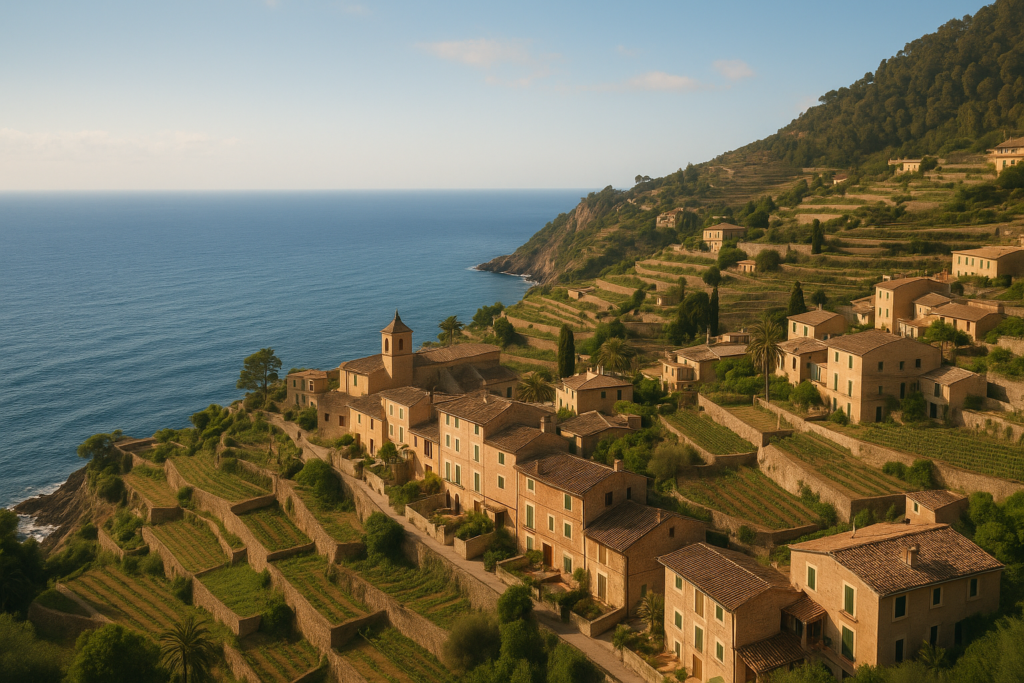
Banyalbufar at a glance
- Famous for sea-facing agricultural terraces (marjades) cut into the Tramuntana cliffs, historically for Malvasia grapes and tomatoes.
- Small pebble cove (Cala Banyalbufar) and the fishing hamlet Port des Canonge are reached by steep tracks down from the village.
- The restored 16th‑century coastal watchtower Talaia de ses Ànimes (Torre del Verger) offers panoramic coastline views.
- The local Malvasier/Malvasia grape was historically prized and the village revives this heritage with an annual wine festival.
- Situated on Mallorca next to the Serra de Tramuntana; terrain includes low and high mountains (Sa Talaia 309 m; Mola de Planícia 942 m).
- Administrative seat of a municipality of 18.1 km2 that borders Estellencs, Puigpunyent, Esporles and Valldemossa.
Before you plan
Nothing in our verified sources indicates closures or major redevelopment that affects the village’s main attractions. Expect narrow roads and steep paths; the small coves are accessed via downhill tracks from the village rather than flat promenades.
Things to do in the area
The draw here is landscape and local history rather than attractions in the conventional sense. Walk the terraces, peek into the tiny harbour, take in the coastal lookout and time a visit for the village’s revived Malvasia wine festival if your trip coincides with it. Most activities are low-cost and self-guided—bring sturdy shoes for the steep tracks.
| Attraction | What it is | Price/entry | Best for |
|---|---|---|---|
| Sea terraces (marjades) | Dramatic, sea-facing agricultural terraces built into the Tramuntana cliffs for Malvasia grapes and tomatoes | – | Landscape photography; slow walking |
| Talaia de ses Ànimes (Torre del Verger) | Restored 16th-century coastal watchtower with panoramic views | – | Short historical stop, viewpoints |
| Cala Banyalbufar | Small pebble cove reached by steep tracks | – | Quiet sea dip; intimate coastal atmosphere |
| Port des Canonge | Fishing hamlet below the village, reached on foot via steep paths | – | Seaside strolls; local fishing ambience |
| Malvasia wine festival | Annual village celebration of the revived local Malvasia sweet wine | – | Wine lovers; cultural interest |
Walk the marjades (sea terraces)
The agricultural terraces carved into the Tramuntana cliffs are Banyalbufar’s signature sight. Historically worked almost exclusively for agriculture by the local inhabitants, these marjades once produced prized Malvasia grapes (often referred to as Malvasier) and tomatoes. Much of the visual appeal comes from the layered stone walls and the way the terraces cling to the slope above the sea—this is territory for slow walking and photography rather than coastal sunbathing.
Talaia de ses Ànimes (Torre del Verger)
The restored 16th-century tower sits near the village and is one of the easiest ways to get panoramic views along the Tramuntana coastline. It was part of a network of coastal watchtowers historically used to spot threats from the sea; today the restoration makes it an accessible historical viewpoint for short visits.
Cala Banyalbufar and Port des Canonge
The seaside charms here are intimate and modest. Cala Banyalbufar is a small pebble cove, while Port des Canonge is a tiny fishing hamlet; both lie below the village and are reached by steep tracks that descend from the settlement. Expect a descending walk back up—the return can be tiring for unprepared visitors.
Best beaches in the area
There are no long sandy resort beaches inside the village’s boundaries; coastal spots are small, rocky or pebbly coves best for quiet dips rather than family beach days with facilities.
| Beach | Character | Facilities / Blue Flag |
|---|---|---|
| Cala Banyalbufar | Small pebble cove accessed by steep tracks | – |
The town with kids
Banyalbufar is not a theme-park-style family destination; it suits families who enjoy outdoor walks, short hikes and discovering small harbours. The steep tracks to the cove and the terraces mean young children should be supervised and strollers are impractical. The village’s compact size makes for short transfers between sights but limited dedicated children’s attractions.
How to get to the town and get around
The village is set against the Serra de Tramuntana, so expect winding coastal roads if you arrive by vehicle. Once in the village, most highlights—the terraces, the watchtower and the descent paths to the cove and port—are reached on foot via narrow streets and steep tracks. If you plan to visit neighbouring municipalities (Estellencs, Puigpunyent, Esporles and Valldemossa), allow time for hill roads and changes in elevation.
Where to stay in Banyalbufar
Accommodation within the municipality clusters around the village itself; staying in the town places you within easy walking distance of viewpoints and the tracks down to the sea. If you prefer more services or a wider choice of restaurants you may look to nearby towns in the Tramuntana range, but expect to trade proximity to the terraces for added amenities.
Best time to visit the area
Weather can be changeable: rainfall can occur at any time of year. Plan with flexibility and a rain alternative. If you’re arranging a visit around the local wine culture, seek dates that align with the village’s annual Malvasia wine festival.
| Season | Months | What to expect |
|---|---|---|
| Spring | – | Good for walking and terraces in bloom; variable weather possible |
| Summer | – | Warmer, coastal sights accessible; still be aware that rain can occur |
| Autumn | – | Quiet shoulder season with changing light across the cliffs; possible heavy downpours on occasion |
| Winter | – | Milder than continental interiors but changeable; quieter village experience |
History of the area
The place takes its original name from a Moorish settlement founded in the 10th century. After the Catalan conquest of Majorca in 1229 it came under the control of Gilabert de Cruïlles and Ramon sa Clusa. In the Middle Ages the Barony of Banyalbufar operated with a near‑absolutist local government. For centuries the inhabitants devoted themselves almost exclusively to agriculture, a legacy visible today in the sea terraces that produced highly prized local Malvasia grapes.
Practical info
- Topography: the municipality sits next to the Serra de Tramuntana and includes low and high mountains (Sa Talaia 309 m; Mola de Planícia 942 m), so expect elevation changes within short distances.
- Municipal facts: Banyalbufar is the administrative seat of an 18.1 km2 municipality bordering Estellencs, Puigpunyent, Esporles and Valldemossa—useful if you plan multi-stop routes through the Tramuntana.
- Weather caution: rainfall can occur year-round; the heaviest recorded rainfall was on 10 June 1975 (170 L/m2), underscoring that heavy downpours, though rare, have occurred.
- Walking access: Cala Banyalbufar and Port des Canonge require steep descents from the village—plan footwear and fitness accordingly.
Worth it for: people who prize dramatic coastal terraces, quiet seaside coves reached on foot, and short historical stops such as a restored watchtower. Less so if: you want long sandy beaches, a wide range of restaurants and nightlife, or flat promenades—this is a village built into cliffs, not a full-service resort.
How we assess this guide
This guide is compiled by editors cross-checking local historical, geographical and cultural sources. We flag closures or major changes where verified and avoid first‑hand impressions where not corroborated. We prioritise verifiable facts about terrain, history and notable sights so you can set realistic expectations and reduce disappointment on arrival.
Frequently asked questions
How do I reach the village from elsewhere on Mallorca?
The village sits on the Tramuntana coast and is connected by the hill roads that link neighbouring municipalities such as Estellencs, Puigpunyent, Esporles and Valldemossa. Expect narrow, winding roads typical of a Serra de Tramuntana hillside route.
Is Banyalbufar expensive to visit?
The village is small with limited services; expenses will depend on where you stay and whether you use nearby towns for a wider choice of restaurants and accommodations. There is no single price profile in the sources; plan for limited local options.
Which is the best beach to visit here?
Cala Banyalbufar is the main local coastal spot: a small pebble cove reached by steep tracks from the village. It is the go-to place for a quiet swim rather than a full-service beach day.
How many days should I spend in Banyalbufar?
One or two days suit most visitors who want to explore the terraces, take in the watchtower vistas and walk down to the cove. The municipality’s compact scale means highlights are close but the steep terrain rewards a relaxed pace.
Is Banyalbufar good for families with children?
Families who enjoy outdoor walks and short hikes will find it rewarding, but steep descents to coves and the terraced terrain mean close supervision is required for young children; strollers are not practical on the tracks.
Can I visit the terraces and the watchtower on foot?
Yes. The terraces are best appreciated on foot, and the restored Talaia de ses Ànimes (Torre del Verger) is a short historical stop offering panoramic views along the coastline.
Are the coastal tracks to the coves difficult?
The tracks down to Cala Banyalbufar and Port des Canonge are steep. They are manageable for people comfortable with uneven uphill returns, but they can be tiring on the way back.
What should I know about the weather?
Rainfall can occur all year round; the heaviest recorded rainfall on record was 10 June 1975 (170 L/m2). Pack layers and a rain option even in otherwise dry seasons.
When is the village’s wine festival?
The village holds an annual festival celebrating its revived local Malvasia sweet wine. Specific dates are not provided in the verified sources; check local listings for the year you plan to travel.
Are there restaurants and shops in the village?
The village has limited services compared with larger resort towns; for a broader selection of restaurants and shops you may consider nearby towns in the Tramuntana area.
Is Banyalbufar part of the Serra de Tramuntana?
Yes—the municipality lies next to the Serra de Tramuntana mountain range, and its cliffs and terraces are directly related to that terrain.
What are the highest and lowest mountains in the municipality?
The lowest mountain is Sa Talaia at 309 m and the highest is Mola de Planícia at 942 m, reflecting the local variation in elevation within the municipality.
Which municipalities border Banyalbufar?
Banyalbufar borders Estellencs, Puigpunyent, Esporles and Valldemossa—useful to know if you plan a multi-stop itinerary through the Tramuntana.
Does the village have a long agricultural history?
Yes. Historically the inhabitants devoted themselves almost exclusively to agriculture, and the terraces were specifically used to cultivate prized Malvasia grapes and tomatoes.
What’s a notable historical point from the Middle Ages?
After the Catalan conquest of Majorca in 1229, Banyalbufar came under the control of Gilabert de Cruïlles and Ramon sa Clusa, and during the Middle Ages the Barony of Banyalbufar exercised a near‑absolutist local government.
Plan the wider trip
Banyalbufar on the map
Read next
This place sits on the Illes Balears. Read the full Illes Balears guide → or open the interactive map to see everything we have mapped nearby.
How this page is maintained. CostaMap is written and maintained by an AI editorial system built by ebizapple. Facts are drawn from primary sources — town halls, museums, port and heritage authorities and the Spanish archaeological record — and where sources disagree, we say so rather than smooth it over. Photographs marked as ours are taken on location. This page was last reviewed on 14 August 2026. Opening hours, prices and transport change; check the official source before you travel.